Maps of Town of Callicoon

Jeffersonville
1 : 24000
Jeffersonville
1 : 24000
Livingston Manor
1 : 62500
Livingston Manor
1 : 62500
Livingston Manor
1 : 62500
Livingston Manor
1 : 62500
Livingston Manor
1 : 62500
Livingston Manor
1 : 62500
Livingston Manor
1 : 62500
Livingston Manor
1 : 62500
Monticello
1 : 125000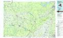
Monticello
1 : 100000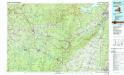
Monticello
1 : 100000
Sullivan County.
1 : 130000 Burr, David H., 1803-1875
Sullivan County.
1 : 158400 Bien, Joseph Rudolf
Wayne, Pike counties.
1 : 300000 Gray, Ormando Willis; Walling, H. F.
Map of the county of Ulster / by David H. Burr ; engd. by Rawdon, Clark & Co., Albany, & Rawdon, Wright & Co., New York.
from An atlas of the state of New York, designed for the use of engineers, containing a map of the state and of the several counties. / Projected and drawn ... under the superintendence and direction of Simeon de Witt.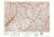
Scranton
1 : 250000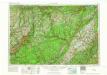
Scranton
1 : 250000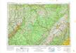
Scranton
1 : 250000
Scranton
1 : 250000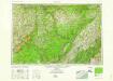
Scranton
1 : 250000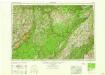
Scranton
1 : 250000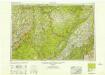
Scranton
1 : 250000
Scranton
1 : 250000
Map of the county of Ulster / by David H. Burr ; engd. by Rawdon, Clark & Co., Albany, & Rawdon, Wright & Co., New York.
from An atlas of the state of New York : containing a map of the state and of the several counties. / Projected and drawn under the superintendence and direction of Simeon de Witt ... And also the physical geography of the State ...
Map of the county of Ulster / by David H. Burr ; engd. by Rawdon, Clark & Co., Albany, & Rawdon, Wright & Co., New York.
from An atlas of the state of New York : containing a map of the state and of the several counties / by David H. Burr.
Van Loan's road map of the Catskills and vicinity : all of Greene County, most of Ulster and Delaware counties, and large portions of Albany, Schoharie, Otsego, and Sullivan counties
1 : 221760 Van Loan, Walton Walton Van Loan
"Onondaga, Cortland, Broome, Madison, and Chenango Counties"
from New topographical atlas and gazetteer of New York, comprising a topographical view of the several counties of the state, ... including ... map of the United States and territories ... Compiled from the latest astronomical observations, official surveys and records of the United States and territories ...

