Maps of Firthcliffe

Cornwall-on-Hudson
1 : 24000
Cornwall
1 : 24000
Cornwall
1 : 24000
Cornwall
1 : 24000
Cornwall
1 : 24000
Cornwall
1 : 24000
Cornwall
1 : 24000
Cornwall
1 : 24000
Portion of Orange County. ; Portion of Dutchess & Putnam County.
from Atlas of the Hudson River Valley from New York city to Troy, including a section of about 8 miles in width. Published by Watson & co. Compiled from official records and careful surveys, under the supervision of F. W. Beers.
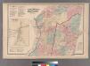
Plan of Cornwall Orange County. Spread E-W
from Atlas of the Hudson River Valley from New York city to Troy, including a section of about 8 miles in width. Published by Watson & co. Compiled from official records and careful surveys, under the supervision of F. W. Beers.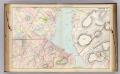
14 Orange, Dutchess, Putnam counties.
1 : 14400 Watson & Co. (New York, N.Y.)
Portion of Orange County. ; Portion of Putnam County.
from Atlas of the Hudson River Valley from New York city to Troy, including a section of about 8 miles in width. Published by Watson & co. Compiled from official records and careful surveys, under the supervision of F. W. Beers.
Schunemunk
1 : 62500
Schunemunk
1 : 62500
Schunemunk
1 : 62500
Schunemunk
1 : 48000
Schunemunk
1 : 62500
Schunemunk
1 : 62500
Schunemunk
1 : 62500
Schunemunk
1 : 62500
Schunemunk
1 : 62500
Schunemunk
1 : 62500
Schunemunk
1 : 62500
Schunemunk
1 : 62500
Schunemunk
1 : 62500
Schunemunk
1 : 62500
Schunemunk
1 : 62500
Schunemunk
1 : 62500
New Windsor [Township]; New Windsor [Village]
from County atlas of Orange, New York / from actual surveys by and under the direction of F.W. Beers.