Maps of Albany County

Clarksville
1 : 24000
Clarksville
1 : 24000
Clarksville
1 : 24000
Clarksville
1 : 24000
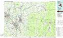
Albany
1 : 62500
Albany
1 : 62500
Albany
1 : 62500
Albany
1 : 62500
Albany
1 : 62500
Albany
1 : 62500
Albany
1 : 62500
Albany
1 : 62500
Albany
1 : 62500
Albany
1 : 62500
Albany
1 : 62500
Albany
1 : 62500
Albany
1 : 62500
Albany
1 : 62500
Albany
1 : 62500
Albany
1 : 62500
Albany
1 : 62500
New Scotland. [Township]; New Salem [Village]; Clarksville Business Directory.; New Salem Business Directory.; Clarksville [Village]
from New topographical atlas of the counties of Albany and Schenectady, New York : from actual surveys / by S.N. & D.G. Beers and assistants.
Coeymans [Village]; Indian Fields Business Directory.
from New topographical atlas of the counties of Albany and Schenectady, New York : from actual surveys / by S.N. & D.G. Beers and assistants.
Bethlehem [Township]
from New topographical atlas of the counties of Albany and Schenectady, New York : from actual surveys / by S.N. & D.G. Beers and assistants.
Westerlo [Township]
from New topographical atlas of the counties of Albany and Schenectady, New York : from actual surveys / by S.N. & D.G. Beers and assistants.
Albany and vicinity, New York / Henry Gannett, chief topographer ; H.M. Wilson, geographer in charge ; triangulation by N.Y. State Survey and by U.S. Coast and Geodetic Survey ; topography by Frank Sutton and J.H. Jennings
1 : 62500 Annotatie geografische gegevens: Opname: 1891-1892 Henry Gannett 1846-1914; Wilson, H.M.; Sutton, Frank; Jennings, J.H.; N.Y. State Survey; US Coast and Geodetic Survey [Washington, D.C. : U.S. Geological Survey]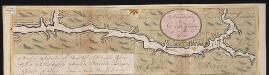
Nieuwe afteekeningh van de Noord Rivier met alle desselfs ancker plaetsen dieptens banken en klippen, geleegen in Nieuw Nederlandt [south part]
United States Gerard van Keulen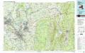
Albany
1 : 100000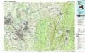
Albany
1 : 100000