Maps of Montgomery County

Amsterdam
1 : 24000
Amsterdam
1 : 24000
Amsterdam
1 : 24000
Amsterdam
1 : 24000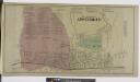
The Village of Amsterdam [Village]; Amsterdam Business Directory.
from Atlas of Montgomery and Fulton counties, New York. From actual surveys / by and under the direction of B. Nichols ; assisted by H.B. Stranahan ... [et al.]
Amsterdam Montgomery Co. [Township]; Hagman's Mills Business Directory. ; Rock City Business Directory. ; Hagmans Mills [Village]; Rock City [Village]
from Atlas of Montgomery and Fulton counties, New York. From actual surveys / by and under the direction of B. Nichols ; assisted by H.B. Stranahan ... [et al.]
Amsterdam
1 : 62500
Amsterdam
1 : 62500
Amsterdam
1 : 62500
Amsterdam
1 : 62500
Amsterdam
1 : 62500
Amsterdam
1 : 62500
Amsterdam
1 : 62500
Amsterdam
1 : 62500
Amsterdam
1 : 62500
Amsterdam
1 : 62500
Amsterdam
1 : 62500
Amsterdam
1 : 62500
Amsterdam
1 : 62500
Amsterdam
1 : 62500
Princetown [Towship]
from New topographical atlas of the counties of Albany and Schenectady, New York : from actual surveys / by S.N. & D.G. Beers and assistants.
Albany, Schenectady counties.
1 : 151000 Burr, David H., 1803-1875
Map of Schenectady County
from New topographical atlas of the counties of Albany and Schenectady, New York : from actual surveys / by S.N. & D.G. Beers and assistants.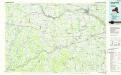
Amsterdam
1 : 100000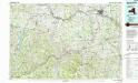
Amsterdam
1 : 100000
Outline Map of Fulton Co. New York.
from Atlas of Montgomery and Fulton counties, New York. From actual surveys / by and under the direction of B. Nichols ; assisted by H.B. Stranahan ... [et al.]
[Schenectady County].
from New York Atlas.
Map of Saratoga County
from New topographical atlas of Saratoga Co., New York, from actual surveys by S. N. & D. G. Beers and assistants.
Map of the county of Saratoga / by David H. Burr ; engd. by Rawdon, Clark & Co., Albany, & Rawdon, Wright & Co., N. York.
from An atlas of the state of New York : containing a map of the state and of the several counties / by David H. Burr.

