Maps of Pendleton County

Whitmer
1 : 24000
Whitmer
1 : 24000
Horton
1 : 62500
Horton
1 : 62500
Horton
1 : 48000
Horton
1 : 48000
Beverly
1 : 125000
Beverly
1 : 125000
Beverly
1 : 125000
Beverly
1 : 125000
Beverly
1 : 125000
Beverly
1 : 125000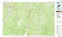
Elkins
1 : 100000
Randolph, Pendleton counties.
1 : 251000 White, M. Wood
Charlottesville
1 : 250000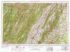
Charlottesville
1 : 250000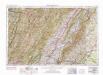
Charlottesville
1 : 250000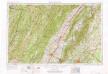
Charlottesville
1 : 250000
Charlottesville
1 : 250000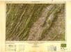
Charlottesville
1 : 250000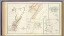
Virginia, Averell routes.
1 : 760320 United States. War Department
Hanging Rock; Monocacy.
Hotchkiss, Jed.
Milford, Brock's Gap, Moorefield, New Creek, etc.
Hotchkiss, Jed.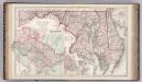
Maryland, Delaware, Washington D.C.
1 : 633600 Gray, Ormando Willis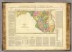
Maryland.
1 : 850000 Buchon, J. A. C.; Carey, H. C.; Lea, I.
Karte des Kriegs-Theaters in Virginien
1 : 890000 Virginie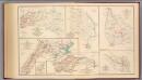
2d Corps A.N. Va., camps, pickets, routes.
Hotchkiss, Jed.
Maryland.
1 : 1385000 Finley, Anthony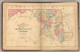
Martenet's Map of Maryland, Atlas Edition.
1 : 950400 Martenet, Simon J.

