Maps of Newton

Newton East
1 : 24000
Newton East
1 : 24000
Newton East
1 : 24000
Franklin Furnace
1 : 62500
Franklin Furnace
1 : 62500
Franklin Furnace
1 : 62500
Franklin Furnace
1 : 62500
Franklin
1 : 62500
Franklin
1 : 62500
Franklin
1 : 62500
1 Kittatinny Valley, Mtn.
1 : 63360 Vermeule, C. C. (Cornelius Clarkson), 1858-1950
3 Central Highlands.
1 : 63360 Vermeule, C. C. (Cornelius Clarkson), 1858-1950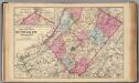
Sussex Co., N.J.
1 : 126720 Beers, F. W. (Frederick W.)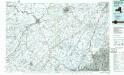
Middletown
1 : 100000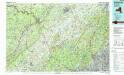
Middletown
1 : 100000
Orange, Rockland counties.
1 : 151000 Burr, David H., 1803-1875
Outline and Index Map of Atlas of New York City.
from Atlas of the borough of Manhattan, city of New York.
Septentrionale du New Jersey, et Positions des Armees Americaine et Britannique en 1776.
1 : 300000 Marshall, John
Northern Part of New Jersey, shewing the the American and British Armies after crossing the North River in 1776.
1 : 290000 Marshall, John
Map of the counties of Orange and Rockland / by David H. Burr ; engd. by Rawdon, Clark & Co., Albany, & Rawdon, Wright & Co., N. York.
from An atlas of the state of New York, designed for the use of engineers, containing a map of the state and of the several counties. / Projected and drawn ... under the superintendence and direction of Simeon de Witt.
Sunset Park, Bush Terminal. (cont.)
From District 7
A plan of the northern part of New Jersey : shewing the positions of the American and British armies after crossing the North River in 1776 / drawn by S. Lewis from surveys by order of Gen. Washington ; engrav'd by Fs. Shallus.
from Revolutionary War, 1775-1783
Thirty miles round the city of New York
from Whole
Map of the counties of Orange and Rockland / by David H. Burr ; engd. by Rawdon, Clark & Co., Albany, & Rawdon, Wright & Co., N. York.
from An atlas of the state of New York : containing a map of the state and of the several counties / by David H. Burr.
40 miles around New York
1 : 158400 H.H. Lloyd & Co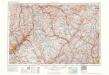
Scranton
1 : 250000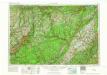
Scranton
1 : 250000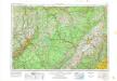
Scranton
1 : 250000
Scranton
1 : 250000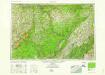
Scranton
1 : 250000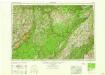
Scranton
1 : 250000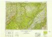
Scranton
1 : 250000

