Maps of Colts Neck Township

Marlboro
1 : 24000
Marlboro
1 : 24000
Marlboro
1 : 24000
Marlboro
1 : 24000
Marlboro
1 : 24000
Marlboro
1 : 24000
Marlboro
1 : 24000
Sandy Hook
1 : 62500
Sandy Hook
1 : 62500
Sandy Hook
1 : 62500
Sandy Hook
1 : 62500
Sandy Hook
1 : 62500
Sandy Hook
1 : 62500
Sandy Hook
1 : 62500
Sandy Hook
1 : 62500
Sandy Hook
1 : 62500
Marlboro Business Notices. ; Marlboro [Township]
from Atlas of Monmouth co., New Jersey. From recent and actual surveys and records, under the superintendence of F.W. Beers.
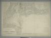
9 Monmouth shore.
1 : 63360 Vermeule, C. C. (Cornelius Clarkson), 1858-1950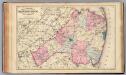
Monmouth Co., N.J.
1 : 126720 Beers, F. W. (Frederick W.)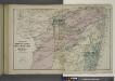
Portions of Middletown, Shrewsbury and Ocean Townships. [Townships]
from Atlas of Monmouth co., New Jersey. From recent and actual surveys and records, under the superintendence of F.W. Beers.
Freehold [Township]; Freehold Business Notices.
from Atlas of Monmouth co., New Jersey. From recent and actual surveys and records, under the superintendence of F.W. Beers.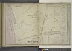
Portion of Long Branch [Village]
from Atlas of Monmouth co., New Jersey. From recent and actual surveys and records, under the superintendence of F.W. Beers.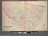
Monmouth County, Double Page Plate No. 30 [Map of Middle Township]
From Wolverton's atlas of Monmouth County, New Jersey : compiled from actual surveys, state and county official records and private plans.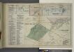
Long Beach Business Notices. ; Leedsville [Village]; Tinton Falls [Village]; Tinton Falls Business Notices. ; Shrewsbury [Village]; Monmouth Park and Oceanport [Villages]; Oceanport and Vicinity Monmouth Park Business Notices.
from Atlas of Monmouth co., New Jersey. From recent and actual surveys and records, under the superintendence of F.W. Beers.
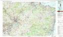
Navesink
1 : 125000
Navesink
1 : 125000
Navesink
1 : 125000
Hammods Atlas of New York City and the metropolitan district
Trenton
1 : 100000