Maps of Newark

Maps of Newark

$title$

Elizabeth

1 : 24000
$title$

Elizabeth

1 : 24000
$title$

Elizabeth

1 : 24000
$title$

Elizabeth

1 : 24000
$title$

Elizabeth

1 : 24000
$title$

Elizabeth

1 : 24000
$title$

Elizabeth

1 : 24000
$title$

Elizabeth

1 : 24000
$title$

20B - N.Y. City (Aerial Set).

from Sectional aerial maps of the City of New York / [photographed and assembled under the direction of the chief engineer, July 1st, 1924].
$title$

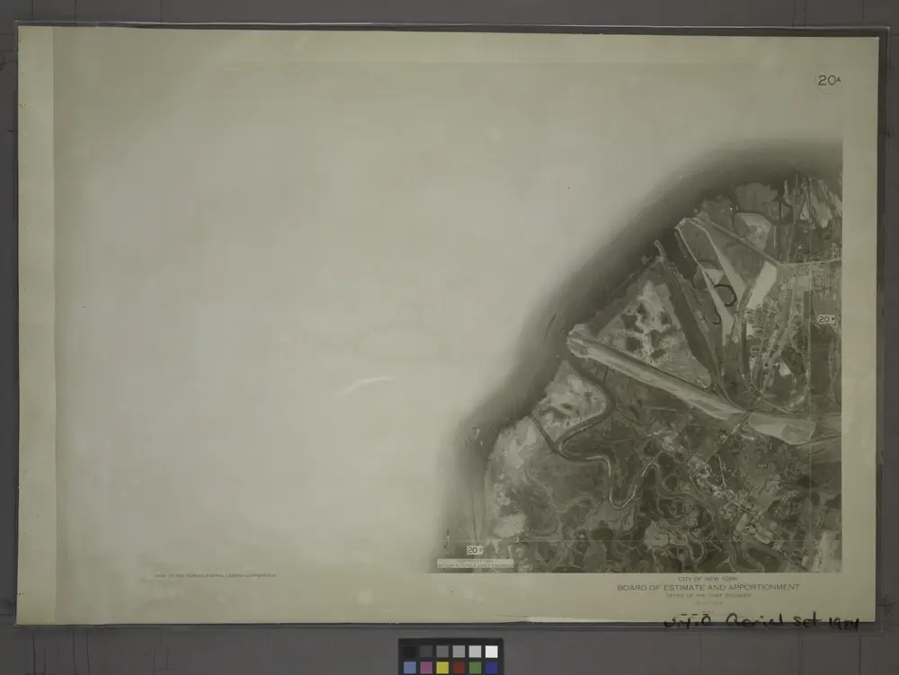
20A - N.Y. City (Aerial Set).

from Sectional aerial maps of the City of New York / [photographed and assembled under the direction of the chief engineer, July 1st, 1924].
$title$

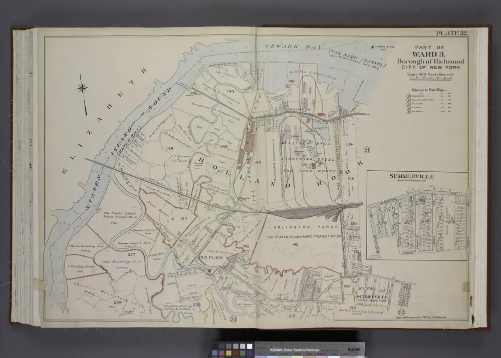
Part of Ward 3. [Map bound by State Line, Richmond (Shore Road) Terrace, Holland Ave, John St, Washington Ave, Irving PL, South Ave, Old Place Creek; Summerville - Washington Ave, South Ave, Irving PL, Garfield Ave, Dechen Ave]

from Atlas of the borough of Richmond, city of New York.
$title$

Section 1.

from Atlas of Staten Island, Richmond County, New York, from official records and surveys; compiled and drawn by F. W. Beers.
$title$

Village of Port Richmond.

from Atlas of Staten Island, Richmond County, New York, from official records and surveys; compiled and drawn by F. W. Beers.
$title$

Part of Ward 3. [Map bound by State Line, Richmond Terrace (Shore RD), Arlington Ave, Baltimore and Ohio Railroad, Western Ave, Washington Ave, Old Place Creek]

from Atlas of the city of New York, borough of Richmond, Staten Island. From actual surveys and original plans, by George W. and Walter S. Bromley.
$title$

Jersey City, V. 1, Double Page Plate No. 36 [Map bounded by Newark Bay, E. 24th St., W. 24th St., Avenue E, W. 7th St.] / compiled under the direction of and published by G.M. Hopkins Co.

From V. 1
$title$

Borough of Richmond, Topographical Survey.

from Borough of Richmond, Topographical Survey.
$title$

Sheet No. 8. [Includes New York and New Jersey Boundary Line, Elm Park and Port Richmond,]

from Borough of Richmond, Topographical Survey.
$title$

Borough of Richmond, Topographical Survey.

from Borough of Richmond, Topographical Survey.
$title$

Part of Ward 3. [Map bound by Winant St (Monroe), Richmond Terrace, Pierhead & Bulkhead Line, Nicholas Ave, Castleton Ave (Hatfield), Grove PL (Woodland PL), Charles Ave, Richmond Ave, Prospect St, Morningstar Road, David PL]

from Atlas of the city of New York, borough of Richmond, Staten Island. From actual surveys and original plans, by George W. and Walter S. Bromley.
$title$

Part of Ward 3. [Map bound by Van Pelt Ave, Washington (Old Place Road) Ave, John St, Martineau St, Richmond (Shore Road) Terrace, Pier & Bulkhead line]

from Atlas of the borough of Richmond, city of New York.
$title$

Sheet No. 20. [Includes Lamberts Lane, South Avenue and Hughes Avenue in Bloomfield.]; Borough of Richmond, Topographical Survey.

from Borough of Richmond, Topographical Survey. Staten Island. Topographical Bureau.,
$title$

Sheet Nos. 5 & 12. [Sheet No. 5. Includes New York and New Jersey Boundary Line, and,(Fresh Kills Island of Meadow). - Sheet No. 12. Includes Buckwheat Island and Marks Creek.]; Borough of Richmond, Topographical Survey.

from Borough of Richmond, Topographical Survey. Staten Island. Topographical Bureau.,
$title$

Sheet No. 13. [Includes Old Place, (Elizabeth Grove Road) Elizabeth Grove Avenue, (Arlington), Western Avenue.]; Borough of Richmond, Topographical Survey.

from Borough of Richmond, Topographical Survey. Staten Island. Topographical Bureau.,
$title$

Part of Ward 3. [Map bound by Union Ave, Staten Island Rapid Transit R.R., De Hart Ave (Central Ave), Richmond Terrace, Pierhead and Bulkhead Line, Winant St (Monroe Ave), Simonson Ave, Van Name Ave, Van Pelt Ave, Maple Ave]

from Atlas of the city of New York, borough of Richmond, Staten Island. From actual surveys and original plans, by George W. and Walter S. Bromley.
$title$

Sheet No. 21. [Includes (Graniteville) from South Avenue to Watchogue Road, and from Lisk Avenue to Kirshon Avenue.]; Borough of Richmond, Topographical Survey.

from Borough of Richmond, Topographical Survey. Staten Island. Topographical Bureau.,
$title$

Part of Ward 3. [Map bound by Nicholas Ave, Richmond Terrace, Pierhead and Bulkhead Line, Richmond Ave, Charles Ave, Grove PL, Castleton Ave (Hatfield)]

from Atlas of the city of New York, borough of Richmond, Staten Island. From actual surveys and original plans, by George W. and Walter S. Bromley.
$title$

Newark, V. 1, Double Page Plate No. 1 [Map bounded by Centre St., Passaic River, Market St., Broad St.] / by J.M. Lathrop and L.J.G. Ogden ; assisted by E. Robinson and G.M. Monroe.

From V. 1, 1911.
$title$

Part of Ward 3. [Map bound by Northfield Ave (Franklin), Richmond Terrace, Pierhead and Bulkhead Line, De Hart Ave (Central), Staten Island Rapid Transit R.R., Union Ave, Brabant St (Beech), Gridley Ave (Columbus), Harbor Road, Lockman Ave, Andros Ave, Mersereau Ave, Grandview Ave, South Ave; Shooters Island - Standard Ship Building Co.]; Atlas of the city of New York, borough of Richmond, Staten Island. From actual surveys and original plans, by George W. and Walter S. Bromley.

from Atlas of the city of New York, borough of Richmond, Staten Island. From actual surveys and original plans, by George W. and Walter S. Bromley. Bromley, George Washington,
$title$

Staten Island, Plate No. 30 [Map bounded by Richmond, Bennett, Cottage Pl., Pond]

From Atlas 159, 1885.
$title$

Part of Ward 3. [Map bound by Richmond Ave, Albion PL, Washington PL, Simonson PL, Catharine St, Jewett Ave, Post Ave, Courtland St (Madison Ave), Catharine St, Palmers Run, Barrett Ave, Decker Ave, Riley PL, John St]

from Atlas of the city of New York, borough of Richmond, Staten Island. From actual surveys and original plans, by George W. and Walter S. Bromley.
© MapTiler © OpenStreetMap contributors
How does it work?
These instructions will show you how to find historical maps online.
Getting started
Type the place name in the search box to find the exact location. You can further adjust the search by zooming in and out.
Zoom
Zoom in and out with the buttons or use your mouse or touchpad natively.
Exact Area tool
Click here and draw a rectangle over the map to precisely define the search area.
Set filters
Narrow your search with advanced settings, such as Years (from/to), Fulltext, Publisher, etc.
Results
See the results of your search on the right side. You can scroll down to find more maps of this location.
?

Download OldMapsOnline Mobile