Maps of White Lake

White Lake
1 : 62500
Singletary Lake
1 : 24000
Singletary Lake
1 : 24000
Rowan
1 : 24000
White Lake
1 : 24000
Tomahawk
1 : 24000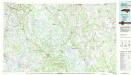
Elizabethtown
1 : 100000
Brandywine.
1 : 42240 Beers, D. G.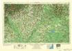
Florence
1 : 250000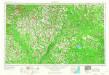
Florence
1 : 250000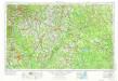
Florence
1 : 250000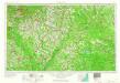
Florence
1 : 250000
Map Of South Carolina (northeast portion)
1 : 380160 Wilson, John
North-Carolina.
Scott, Joseph
Campaign maps Savannah-Washington, D.C.
United States. War Department
Savannah-Goldsborough campaign maps.
United States. War Department
Part of the Military Department of The South, embracing portions of Georgia and South Carolina. [Eastern Part]
Part of the Military Department of The South, embracing portions of Georgia and South Carolina. [Eastern Part]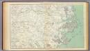
Gen. map III.
1 : 633600 United States. War Department
North Carolina With Part Of Virginia & South Carolina.
1 : 506880 Colton, J. H.
Prang's War Map. North Carolina Coast Line
Prang's War Map. North Carolina Coastline L. Prang & Co.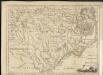
A new and accurate map of North Carolina in North America
1 : 1147000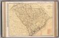
South Carolina.
1 : 760000 Rand McNally and Company
Prang's Naval Expedition Maps: North Carolina coast line
Prang's Naval Expedition Maps: North Carolina coast line L. Prang & Co.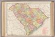
South Carolina.
1 : 760000 Rand McNally and Company
South Carolina.
1 : 2012000 Colton, G. Woolworth
Carte des costes de la Floride Françoise, suivant les premieres découvertes
Bellin, Jacques Nicolas
South Carolina.
Rand McNally and Company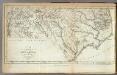
North Carolina.
1 : 1525000 Morse, Jedidiah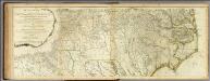
Map Of North And South Carolina With Their Indian Frontiers. (Northern Section)
1 : 530000 Jefferys, Thomas

