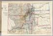
Maps of Las Animas County

Thatcher
1 : 24000
Thatcher
1 : 24000
Thatcher
1 : 24000
Apishapa
1 : 125000
Apishapa
1 : 125000
Apishapa
1 : 125000
Apishapa
1 : 125000
Apishapa
1 : 125000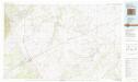
Walsenburg
1 : 100000
62D. Part of South Eastern Colorado.
1 : 253440 Wheeler, G.M.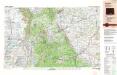
Trinidad
1 : 250000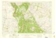
Trinidad
1 : 250000
Trinidad
1 : 250000
Trinidad
1 : 250000
Trinidad
1 : 250000
Trinidad
1 : 250000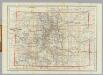
Colorado.
1 : 1267200 Adams, George H. & Son
Map of the State of Colorado.
1 : 665280 Nell, Louis
Thayer's New Map Of The State of Colorado.
1 : 887040 Thayer, H. L.
Rand, McNally & Co.'s new geological map of Colorado.
1 : 760320 Rand McNally and Company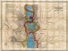
Map Of Colorado Territory, Shewing The System Of Parks.
1 : 760320 Monk, Jacob
From Santa Fe Crossing to Coo-che-to-pa Pass.
1 : 760320 Gunnison, J.W.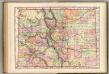
Colorado.
1 : 1000000 Rand McNally and Company
Colorado.
1 : 1850000 Mitchell, Samuel Augustus
Colorado, Utah, Montana, Minnesota.
Arbuckle Bros.
Colorado.
1 : 1850000 Mitchell, Samuel Augustus
Colorado.
1 : 1850000 Mitchell, Samuel Augustus Jr.
Colorado.
1 : 1800000 Mitchell, Samuel Augustus
State of Colorado.
1 : 950400 U.S. General Land Office
Colorado.
1 : 2100000 Rand McNally and Company
Colorado.
1 : 1330560 Cram Atlas Company
Thayer's Map Of Colorado.
1 : 1520640 Thayer, H. L.