Maps of New Cumberland

East Liverpool South
1 : 24000
East Liverpool South
1 : 24000
East Liverpool South
1 : 24000
East Liverpool South
1 : 24000
Wellsville
1 : 62500
Wellsville
1 : 62500
Hancock, Brooke, Ohio, Marshall counties.
1 : 297000 White, M. Wood
Upper Ohio River and Valley part IV, 47 to 64 miles below Pittsburgh ... (with) New Cumberland, W.V., Newburgh, Sloans Sta., O., McCoys Station, O.
1 : 31680 Hayes, Eli L.
Upper Ohio River and Valley part III, 32 to 46 miles below Pittsburgh (with) Smiths Ferry, Glasgow, Industry.
1 : 31680 Hayes, Eli L.
Lloyd's Military Campaign Charts: Virginia Pan-Handle
Lloyd's Military Campaign Charts, showing the principal places of interest, compiled from official data by Gen. E.L. Viele and C. Haskins. Published under the auspices of the American Geographical and Statistical Society. Virginia Pan-Handle.
East Liverpool
1 : 100000
East Liverpool
1 : 100000
Pittsburgh.
1 : 380000 Rand McNally and Company
Canton
1 : 250000
Canton
1 : 250000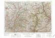
Canton
1 : 250000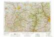
Canton
1 : 250000
Canton
1 : 250000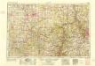
Canton
1 : 250000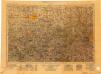
Canton
1 : 250000
Composite: Ohio River (pl. 1-4)
1 : 316800 Tardieu, P.F.
Pennsylvania, Western Section.
1 : 539000 Rand McNally and Company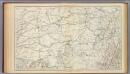
Gen. map V.
1 : 633600 United States. War Department
The state of Pennsylvania / reduced with permission from Reading Howells map, by Samuel Lewis; Smither, sculp.; Carey's American atlas.
from Carey's American atlas. Carey, Mathew; Lewis, Samuel; Barker, W. (William),
Pennsylvania.
1 : 530000 Rand McNally and Company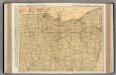
Ohio. (Northern Section)
1 : 586000 Rand McNally and Company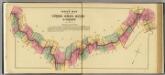
Index map to Atlas of the Upper Ohio River & Valley.
1 : 506880 Hayes, Eli L.
Pennsylvania.
1 : 1800000 Tanner, Henry S.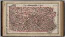
Pennsylvania.
1 : 8000000 Colton, G.W.

