Maps of Dolj
Lambert-Cholesky sheet 2639 (Maglavit)
1 : 20000 Romanian military topographic map sheet under Lambert-Cholensky projection Direcția Topografică Militară geo-spatial.org Direcția Topografică Militară
Carte des Sieges der K. Truppen unter Com.do des FZ. Gr: Clerfait über die bei Calefat unter Com.do
1 Karte : Kupferdruck ; 12 x 17 cm [Trattner]
Carte des Scharmützels der K.K. Truppen unter Com.do des Obristleut Bey ohnweit Calefat in der Wala
1 Karte : Kupferdruck ; 12 x 17 cm [Trattner]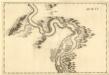
Orsawa - Widdin
Mollova mapová sbírka Marsili, Luigi Ferdinando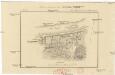
Plan sraženija pod Kalafatom
1 : 20000
Zajecar
1 : 200000 Zaječar (Srbsko) Kartografska radionica
Harta Cailor de Comunicatie din Judetul Doljiu
Rumänien Judeţul Dolj Verkehrsweg
Bulgarisch-rumänische Grenze
1 : 600000 Bulgarien, Rumänien, Grenze
Generalkarte von Zentraleuropa

Generalkarte von Zentraleuropa

XX, uit: General-Karte des oesterreichischen Kaiserstaates mit einem grossen Theile der angrenzenden Länder / durch Josef Scheda ... bearb. und hrsg
1 : 576000 Annotatie geografische gegevens: Maatstokken: oesterreichische Meilen, geografische oder deutsche Meilen, preussische Meilen, türkische Berri, französische Lieues, russische Werste; Maatstok per blad: wiener Klafter, öster. Meilen; Blad XIX: statistische en taalkundige informatie; Blad XIX: legenda [Wien : K.K. Militärisch-Geografisches Institut]
Strassen- und Eisenbahnkarte des oesterreichischen Kaiserthumes
1 : 864000 Blatt 16 Schaller, G. K.K. Militärisch-Geografisches Institut, Karten-Evidenthaltungs-Abteilung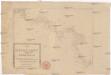
Die Shiffahrt auf der Donau von der Spitze Syrmiens bis in das Schwarze Meer
Bělehrad (Srbsko)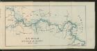
Dunav od Beograda do Radujevca
1 : 750000 Belgrad, Radujevac
[Jižní Rumunsko]
Rumunsko
Bulgaria
Mollova mapová sbírka Hoffmann, Johannes Hoffmann, Johann
Theatrum belli inter imperat. Carol VI. et sult. Achmet IV. in partibus regnorum Serviae et Bosniae
Bulharsko Oettinger, Johann Friedrich Hommanianis Heredibus
Carte de la Roumanie et pays limitrophes. Bukarest
1 : 500000 France. Service géographique de l'armée [Paris] : Service géographique de l'armée
Des Koenigreichs Bulgarien Westliche Hälfte
1 : 1200000 Bulgarien (West)

Sheet XV: Karte Des Oesterreichischen Kaiserstaates.
1 : 576000 Scheda, Josef
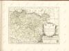
Temeschwarer Bannat. Nach denen neuesten Anzeigen
Temescher Banat, Osmanisches Reich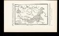
La Serbie de Karageorges et de 1833-78
Serbien Geschichte
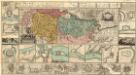
Nagyszeben (Hermannstadt), Brassó (Kronstadt), Bukarest, Craiova, Vidin, Rusčuk
1 : 750000 Brašov (Rumunsko : oblast) Korb, L. K. u. k. Militärgeographisches Institut
Hermannstadt, Kronstadt, Bukarest, Craiova, Vidin, Rusčuk
1 : 750000 Brašov (Rumunsko : oblast) K. k. militär-geographisches Institut
Übersichtskarte von Mittel - Europa

XV, uit: General-Karte des oesterreichischen Kaiserstaates mit einem grossen Theile der angrenzenden Länder / durch Josef Scheda ... bearb. und hrsg
1 : 576000 Annotatie geografische gegevens: Maatstokken: oesterreichische Meilen, geografische oder deutsche Meilen, preussische Meilen, türkische Berri, französische Lieues, russische Werste; Maatstok per blad: wiener Klafter, öster. Meilen; Blad XIX: statistische en taalkundige informatie; Blad XIX: legenda [Wien : K.K. Militärisch-Geografisches Institut]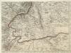
Augustissimo Romanor. Imperatori Iosepho I. Hungaria Regi Invictissimo Mappam Hanc Regni Hungariae
1 : 540000 Mollova mapová sbírka Müller, Johann Christoph