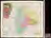
Maps of Gorj

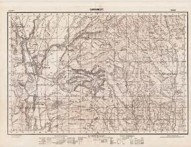
Lambert-Cholesky sheet 2949 (Cărbuneşti)
1 : 20000 Romanian military topographic map sheet under Lambert-Cholensky projection Direcția Topografică Militară geo-spatial.org Direcția Topografică Militară
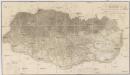
Harta Cailor de Comunicatie din Judetul Gorjiu
Rumänien Gorj Verkehrsweg
Kleine Walachei
1 : 600000 Kleine Walachei
Generalkarte von Zentraleuropa

Carte de la Roumanie et pays limitrophes. Bukarest
1 : 500000 France. Service géographique de l'armée [Paris] : Service géographique de l'armée
Sheet XV: Karte Des Oesterreichischen Kaiserstaates.
1 : 576000 Scheda, Josef
Nagyszeben (Hermannstadt), Brassó (Kronstadt), Bukarest, Craiova, Vidin, Rusčuk
1 : 750000 Brašov (Rumunsko : oblast) Korb, L. K. u. k. Militärgeographisches Institut
Hermannstadt, Kronstadt, Bukarest, Craiova, Vidin, Rusčuk
1 : 750000 Brašov (Rumunsko : oblast) K. k. militär-geographisches Institut
Übersichtskarte von Mittel - Europa

XV, uit: General-Karte des oesterreichischen Kaiserstaates mit einem grossen Theile der angrenzenden Länder / durch Josef Scheda ... bearb. und hrsg
1 : 576000 Annotatie geografische gegevens: Maatstokken: oesterreichische Meilen, geografische oder deutsche Meilen, preussische Meilen, türkische Berri, französische Lieues, russische Werste; Maatstok per blad: wiener Klafter, öster. Meilen; Blad XIX: statistische en taalkundige informatie; Blad XIX: legenda [Wien : K.K. Militärisch-Geografisches Institut]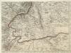
Augustissimo Romanor. Imperatori Iosepho I. Hungaria Regi Invictissimo Mappam Hanc Regni Hungariae
1 : 540000 Mollova mapová sbírka Müller, Johann Christoph
Strassen-Karte der banatischen Militair-Grenze
1 : 440000 Banát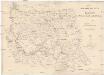
STRASSEN-KARTE der Banatischen MILITAR-GRENZE
1 : 440000 Banát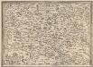
Transilvania [Karte], in: Theatrum orbis terrarum, S. 366.
1 Karte aus Atlas Ortelius, Abraham Vrients, Jan Baptista
Ungarn. Comit. Krassó, Zaránd. Walachei. Illyrien. Siebenbürgen. Comit: Hunyad, Kükülö, Unter- und Ober Weißenburger. Stühle: Dreystuhler, Repser, Schäßburg, Groß Schenker, Medjascher, Leschkirchner, Hermannstädter, Reißmärker, Mühlenbacher & Brooder Stuhl. Districte: Fogaras & Kronstadt
Ungarn Verkehrsweg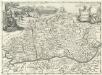
Valachia.
1 : 1400000 Mollova mapová sbírka Bruggen, Johann van der Brugge, Johannes van der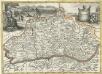
Valachia
1 : 1400000 Mollova mapová sbírka Pfeffel, Johann Andreas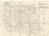
Strassen-Karte der Banatischen Militair-Grenze
1 : 432000 Banát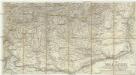
Die Walachei
1 : 800000 Valašsko (Rumunsko)
Blatt VIII, uit: Geologische Übersichts-Karte der Österreichisch-Ungarischen Monarchie / nach den Aufnahmen der K.K. Geologischen Reichsanstalt bearb. von Franz Ritter von Hauer ; gezeichn. von Eduard Jahn
1 : 576000 Annotatie geografische gegevens: Gebaseerd op veldwerk in de jaren 1850 tot 1865 Hauer, Franz Ritter von; Jahn, Eduard; Kaiserlich-Königliche Geologische Reichsanstalt, Wenen Wien : Beck
Carte der Besitznehmung der Wallachey von den K.K. Truppen unter Com.do des F.M. P. v. Sachsen Cobur
1 Karte : Kupferdruck ; 12 x 17 cm [Trattner]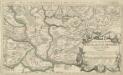
Le Royaume de Hongrie Diuise'en Haute, et Basse, Hongrie auec l'Esclavonie, Subdiuisees en leurs Comtez
1 : 1300000 Mollova mapová sbírka Coronelli, Vincenzo Maria Nolin, Jean Baptiste
Topographische Karte der Grossen und Kleinen Wallachey
1 : 580000 Rumunsko
H.7. Orsova, uit: [Übersichtskarte von Europa 1:750.000]
1 : 750000 Wien : K.u.K. Militärgeographisches Institut
Strassen- und Eisenbahnkarte des oesterreichischen Kaiserthumes
1 : 864000 Blatt 12 Schaller, G. K.K. Militärisch-Geografisches Institut, Karten-Evidenthaltungs-Abteilung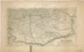
Die Walachei
Generalcharte der Walachey
1 : 740000 Rumunsko Fried, Franz Kunst und Industrie Comptoir
Principatus Transilvaniæ
1 Karte : Kupferdruck ; 47 x 55 cm Homann Johann Baptist Homann