Maps of Carpathian Mountains

Danubius a fonte usque ad ostia
1 : 11100000 1 Kt. in 2 Teilen auf 1 Bl. : Kupferdruck ; 34 x 6 cm, je Teil 17 x 6 cm Weigel, Johann Christoph [Johann Christoph Weigel]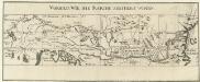
Die Donau, der Fürst aller Europaeischen Flüsse
Mollova mapová sbírka Hoffmann, Johannes Hoffmann, Johann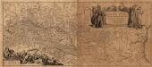
Danvbivs Fluvius Europae Maximus, A Fontibvs Ad Ostia
1 : 2100000 Mollova mapová sbírka Danckertsz, Cornelis Danckerts, Cornelis I.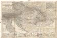
Das Österreichisch-Ungarische Reich
1 : 1850000 Rakousko-Uhersko Berghaus, Hermann Eulenstein, F. Justus Perthes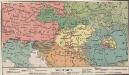
Völkerkarte
Österreich-Ungarn Ethnische Gruppe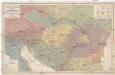
Völker und Sprachen Karte von Österreich und den Unter-Donau-Ländern
1 : 3000000 Rakousko-Uhersko Kiepert, Heinrich Dietrich Reimer
Völker und Sprachen Karte von Österreich und den Unter-Donau-Ländern
1 : 3000000 Evropa střední Kiepert, Heinrich D. Reimer
Völker und Sprachen Karte von Österreich und den Unter-Donau-Ländern
Rakousko-Uhersko Kiepert, Heinrich Riegel, Christoph Dietrich Reimer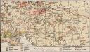
Bodenschätze u. Industrie
Österreich-Ungarn Industrie, Mineralischer Rohstoff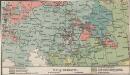
Religionskarte
Österreich-Ungarn Denomination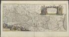
DANVBIVS, | FLUVIUS EUROPÆ MAXIMUS, | A FONTIBVS AD OSTIA. | Cum omnibus Fluminibus, ab utroque latere, | in illum defluentibus.
[Amsterdam : Joan Blaeu]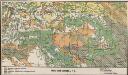
Bodenbenutzung
Österreich-Ungarn Bodennutzung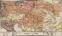
Bevölkerungsdichte
Österreich-Ungarn Bevölkerungsdichte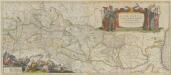
Danubius, Fluvius Europae Maximus, A Fontibus Ad Ostia. Cum omnibus Fluminibus, ab utroque latere, in illum defluentibus. [Karte], in: Theatrum orbis terrarum, sive, Atlas novus, Bd. 1, S. 310.
1 Karte aus Atlas Blaeu, Joan Blaeu, Willem Janszoon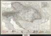
Der österreichische Kaiserstaat
Berghaus, Hermann; Stülpnagel, Friedrich von; Petermann, August; Habenicht, Hermann Perthes
Danubius, Fluvius Europae Maximus, A Fontibus Ad Ostia, Cum omnibus Fluminibus, ab utroque latere, in allum defluentibus. [Karte], in: Le théâtre du monde, ou, Nouvel atlas contenant les chartes et descriptions de tous les païs de la terre, Bd. 1, S. 222.
1 Karte aus Atlas Blaeu, Willem Janszoon und Blaeu, Joan Blaeu, Willem Janszoon
Danubius, Fluvius Europae Maximus. A Fontibus Ad Ostia, Cum omnibus Fluminis, ab utroque latere, in illum fluentibus. [Karte], in: Gerardi Mercatoris et I. Hondii Newer Atlas, oder, Grosses Weltbuch, Bd. 1, S. 233.
1 Karte aus Atlas Mercator, Gerhard und Hondius, Jodocus Jansson, Jan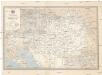
Übersichtskarte der k. k. österreichischen Staatsbahnen und der im Staatsbetriebe befindlichen Privatbahnen
1 : 1449000 Dalmácie jižní (Chorvatsko)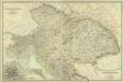
Composite: Austro-Hungarian Monarchy.
1 : 1642000 Johnston, W. & A.K.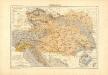
Atlas für Industrie- und Handelsgeographie: Für commercielle und technische Lehranstalten, für Kaufleute und Industrielle
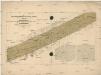
Karte der totalen Sonnenfinsterniss am 8. July 1842
Evropa střední Littrow, Carl Ludwig Lehmann, Jacob Heinrich Wilhelm Verlag der lithographischen Anstalt des Ludwig Mohn
POSTKARTE Saemtlicher K. K. teutsch und hungarischer Erblaender
Evropa střední Hartl, Sebastian bei Sebastian Hartl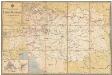
Übersichts-Karte der k. k. österr. Staatsbahnen
1 : 1550000 Evropa jihovýchodní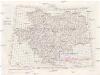
[Jugoslávie 1:200 000]
1 : 25000 Jugoslávie K. u. k Militärgeographisches Institut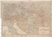
Karta Avstro-Vengrii
1 : 520000 Rakousko-Uhersko Il'jin, A.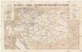
Die Oesterr. u. Ungar. Eisenbahnen der Gegenwart u. der Zukunft
1 : 1850000 Evropa střední Artaria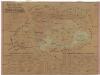
Uibersichts-Karte der Österreichischen Monarchie
1 : 2600000 Evropa jihovýchodní Fleischans, Carl Medau, Karel Vilém C.W. Medau
Volkerkarte v. Oesterreich-Ungarn.
1 : 4000000 Andree, Richard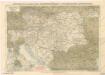
Eisenbahnkarte der österreichisch-ungarischen Monarchie

Rakousko-Uhersko, mapa národopisná
1 : 2750000 Banát Machát, František J. Otto