Maps of Denmark

Regni Daniae in quo sunt ducatus Holsatia et Slesvicum, insulæ Danicæ provinciæ Iutia Scania Blekingia nova tabula
1 Karte : Kupferdruck ; 47 x 55 cm Homann Johann Baptist Homann
Regni Daniae in quo sunt ducatus Holsatia et Slesvicum, insulæ Danicæ provinciæ Iutia Scania Blekingia nova tabula
1 Karte : Kupferdruck ; 47 x 56 cm Homann; Hübner Johann Baptist Homann
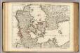
Regni Daniae in quo sunt ducatus Holsatia et Slesvicum insulæ Danicæ provinciæ Iutia Scania Blekingia nova tabula
1 Karte : Kupferdruck ; 47 x 56 cm Homann; Hübner Johann Baptist Homann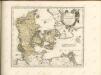

Daniae regnum cum ducatu Holsatiae et Slesvici nec non insulae Danicae et Iutia cum parte Scaniae
1 : 941000 Dánsko Lotter, Tobias Conrad studio Tobiae Conradi Lotteri

[Neuer Atlas der ganzen Erde nach den neuesten Bestimmungen ... : XIII.] Der Daenische Staat und die Gebiete der freien Städte Hamburg und Lübeck
Entworfen und gezeichnet von Dr. F.W. Streit H. Leutemann sc. Leipzig : J.C. Hinrichs'sche Buchhandlung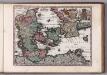
Daniae Reg. cum Ducatu Holsatiae et Slesvici
1 : 500000 Weyerman, Jacob Campo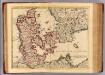
Danemarc.
1 : 970000 L'Isle, Guillaume de, 1675-1726
Dänemark, Schleswig, Holstein u. Lauenburg, nebst den Dänischen Colonien
Hand-Atlas über alle Theile der Erde und über das Weltgebäude Stieler, Adolf Justus Perthes
[Dänemark und die Dänischen Kolonien]
Handatlas über alle Theile der Erde und über das Weltgebäude Stieler, Adolf Justus Perthes
Charte des Königreichs Daenemark, nach Murdochischer Projection und nach den trigonometrischen Charten der König
1 : 919000
Daenemark, Island.
1 : 875000 Weiland, C. F. (Carl Ferdinand), d. 1847
Danemark, Schleswig, Holstein u. Lauenburg, Nebst Den Danischen Colonie'n.
1 : 1500000 Petermann, A.
Danemarc.
1 : 965000 L'Isle, Guillaume de, 1675-1726
Homannův atlas světa
1 : 930000
Danemark, Schleswig, Holstein, Lauenburg.
1 : 1500000 Flemming, Carl
Carte du royaume de Danemarc
1 : 1000000 Dánsko Delisle, Guillaume Iean Covens et Corneille Mortier

Daenemark, Island, die Far-Oer und die Herzogthümer Schleswig, Holstein & Lauenburg
1 : 860000 Dánsko Gräf, Carl Haubold, Georg Geographisches Institut
Daenemark, Island, die Far-Oer und die Herzogthümer Schleswig, Holstein & Lauenburg
1 : 800000 Dánsko Gräf, C. Haubold, G. Geographisches Institut
Karte von dem Koenigreiche Daenemark
1 : 1000000 Dánsko Reilly, Franz Johann Josef von Franz Ioh. Ios. von Reilly
Dania regnvm
Dánsko
[DANIA REGNUM in quo sunt ducatus HOLSATIA et SLESVICUM INSULAE DANICAE et PROVINCIAE IUTIA, SCANIA, BLEKINGIA ET HALLANDIA]
1 : 1050000 Dánsko Wit, Frederick de F. de Wit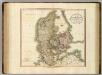
Denmark.
1 : 1100000 Cary, John, ca. 1754-1835
Denmark, Holstein, Mecklenburg, Island.
1 : 2000000 Meyer, Joseph, 1796-1856
Carte du royaume de Danemarck
1 : 1190000 Dánsko Delisle, Guillaume Buache, Philippe Ph. Buache
Denmark.
1 : 840000 Arrowsmith, John


