Maps of Aargau

Le canton de Zurich
1 Karte : Kupferdruck ; 14 x 18 cm s.n.

Zurichgow et Basiliensis provincia [Karte], in: Novus Atlas, das ist, Weltbeschreibung, Bd. 1, S. 257.
1 Karte aus Atlas Blaeu, Joan Blaeu, Willem Janszoon
Zurichgow et Basiliensis provincia
1 : 300000 1 Karte A. van den Broeck fecit apud G. Valk et P. Schenk, Amstelodami
[Zurichgow, et Basiliensis provincia] [Karte], in: Gerardi Mercatoris et I. Hondii Newer Atlas, oder, Grosses Weltbuch, Bd. 1, S. 259.
1 Karte aus Atlas Mercator, Gerhard und Hondius, Jodocus Jansson, Jan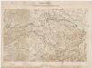
Eisenbahnnetz der Nordostbahn; Übersichtskarte
1 : 250000 Mit Legende. Eidgenössisches Stabsbüro
Zvrichgow et Basiliensis provincia
1 : 310000 Mollova mapová sbírka Broeck, Abraham van den Janssonius Van Waesberge, Johannes II
[Zürich, Basel] [Karte], in: Gerardi Mercatoris Atlas, sive, Cosmographicae meditationes de fabrica mundi et fabricati figura, S. 264.
1 Karte aus Atlas Mercator, Gerhard Montanus, Petrus
Zurichgow et Basiliensis provincia [Karte], in: Le théâtre du monde, ou, Nouvel atlas contenant les chartes et descriptions de tous les païs de la terre, Bd. 1, S. 288.
1 Karte aus Atlas Blaeu, Willem Janszoon und Blaeu, Joan Blaeu, Willem Janszoon
Zurichgow et Basiliensis provincia [Karte], in: Theatrum orbis terrarum, sive, Atlas novus, Bd. 1, S. 294.
1 Karte aus Atlas Blaeu, Joan Blaeu, Willem Janszoon
ZVRICHGOW | et | Basiliensis provincia
[Amsterdam : Joan Blaeu]
Zürich 155, uit: Special-Karte von Mittel-Europa / nach amtlichen Quellen bearbeitet von W. Liebenow
1 : 300000 titelvariant: W. Liebenow's Mittel-Europa; Annotatie: Titel boven de bladen: W. Liebenow's Mittel-Europa Johannes Wilhelm Liebenow 1822-1897 Frankfurt a. M. : Ludwig Ravenstein
Zürich Gebiet
1 : 250000 1 Karte J.H. Streulinus inv. ; J.G. Seiller sculpsit
Zürich 155, uit: [W. Liebenow's Special-Karte von Mittel-Europa]
1 : 300000 titelvariant: W. Liebenow's Mittel-Europa; Annotatie: Titel boven de bladen: W. Liebenow's Mittel-Europa Johannes Wilhelm Liebenow 1822-1897 Hannover : Hermann Oppermann
Schulwandkarte zur Geschichte der Schweiz
1 : 180000 Nordblatt Oechsli, Wilhelm ; Baldamus, Alfred Kartograph. Verlagsanstalt von Georg Lang
Zvrichgow et Basiliensis provincia
1 Karte : Kupferdruck ; 37 x 48 cm Janssonius; Broeck apud Johannem Janssonium
Zvrichgow et Basiliensis provincia
1 Karte : Kupferdruck ; 37 x 48 cm Valck; Schenk; Broeck apud G. Valk et P. Schenk
Zvrichgow et Basiliensis provincia
1 Karte : Kupferdruck ; 37 x 48 cm Blaeu Willem Janszoon Blaeu
Zvrichgow et Basiliensis provincia
1 Karte : Kupferdruck ; 36 x 48 cm Mercator; Blaeu s.n.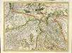
[Zurichgow, et Basiliensis provincia]
1 Karte : Kupferdruck ; 34 x 46 cm Mercator; Hondius Henricus Hondius
[Zurichgow, et Basiliensis provincia]
1 Karte : Kupferdruck ; 34 x 45 cm Mercator s.n.
Nova et accurata Agri Tigurini cum confiniis tabula geographica
1 : 190000 1 Karte ex cel. Scheuchzeri et Gygeri observationibus ; constructa a J. Heinrich Freytag
Neue und exacte geograph. Tabell von der Statt Zürich Gebiett
1 : 600000 1 Karte cura Ioh. Hofmeisteri ; Tobias Lobeck deli. et sculp.
Delineatio aller Quartieren der Statt und Landschaft Zürich
1 : 200000 1 Karte von Joh. Heinr. Freytag
[Keller's Reisekarte der Schweiz]
1 : 500000 1 Karte auf 6 Bl. gezeichnet v. H. Keller ; gest. v. J.J. Scheurmann [Keller], Zürich
Reisekarte der Schweiz
1 : 500000 1 Atlas (1, 6 Bl.) gezeichnet von H. Keller und gestochen von J. Scheurmann = Carte routière de la Suisse / dessinée par H. Keller et gravée par J. Scheurmann bey Fuessli und Comp., Zürich
Nova descriptio ditionis Tigurinae regionumque finitimarum
1 : 95000 1 Karte Joh. Conradus Gygerus, P. delineavit ; Joh. Georgius Gygerus, F. in aes incidi ; curavit per Johannem Meyerum Ao. 1685
<<Der>> Canton Zürich
1 : 335000 1 Karte gezeichnet und verlegt von H. Keller
Karte des Zürcher Gebiets
1 : 96000 Originaltitel: Nova descriptio ditionis Tigurinae, Regionumque finitimarum, Neüe beschreibung der Landschafft Zürich. Im Kupferdruck veröffentlichte verkleinerte und inhaltlich vereinfachte, auf sechs Blätter aufgeteilte Kopie der Grossen Landtafel des Zürcher Gebiets (Gyger-Karte) von 1667. Enthält Nebenkarte der Freiherrschaft Sax-Forstegg sowie bildliche Darstellung der einzelnen Vogteischlösser, der Wappen der Inneren Vogteien, ferner der Stadt Zürich sowie der damaligen männlichen und weiblichen Bekleidung. Herausgeber: Gyger, Hans Georg (1627-1687), Maler und Amtmann des Klosteramts Küsnacht, von Zürich Zeichnung: Gyger, Hans Conrad, andere Schreibweisen: Geiger, Geyger, (1599-1674), Kartograf, Ingenieur und Amtmann des Amts Kappelerhof, von Zürich Stich: Meyer, Johannes (1655-1712), Kupferstecher, von Zürich


