Maps of Cahors
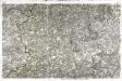
[Cahors]
1 Blatt : 56 x 89 cm s.n.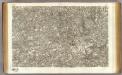
36 Cahors.
1 : 86400 Cassini family; Cassini, Cesar-Francois, 1714-1784
Quercy : Cadurcium
1 : 365000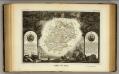
Dept. Du Lot.
1 : 555000 Levasseur, Victor.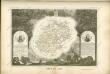

Quercy, olim Cadurcium
1 : 370000 Schenk, Pieter apud Gerardum Valk et Petrum Schenk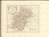

Cadurcium Vernaculé Querci. [Karte], in: Theatrum orbis terrarum, sive, Atlas novus, Bd. 2, S. 134.
1 Karte aus Atlas Blaeu, Joan Blaeu, Willem Janszoon

Coste de Gascogne
Gaskoňsko (Francie) Duval, Pierre Picard, Jacques N. Langois
Quercy Cadurcium [Karte], in: Novus atlas absolutissimus, Bd. 4, S. 179.
1 Karte aus Atlas Janssonius Offizin
Cadurcium Vernaculé Querci. [Karte], in: Le théâtre du monde, ou, Nouvel atlas contenant les chartes et descriptions de tous les païs de la terre, Bd. 2, S. 146.
1 Karte aus Atlas Blaeu, Willem Janszoon und Blaeu, Joan Blaeu, Willem Janszoon
Quercy, olim Cadurcium. [Karte], in: Novus atlas absolutissimus, Bd. 4, S. 182.
1 Karte aus Atlas Janssonius Offizin
Quercy. Cadurcium
Quercy. Cadurcium. [By J. Jansen] [Amsterdam?]
Partie orientale du gouvernement général de la Guienne
1 Karte : Kupferdruck ; 47 x 50 cm Robert de Vaugondy G. et D. Robert de Vaugondy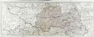
Les généralitéz de Montauban et de Toulouse, 1
2 Blätter : Dezauche
Gouvernement general de Languedoc qui comprend deux generalitéz sçavoir la generalité de Toulouse et celle de Montpellier, 1
1 Blatt : 78 x 49 cm Jaillot
Gouvernement general de Languedoc qui comprend deux generalitéz sçavoir la generalité de Toulouse et celle de Montpellier, 1
1 Blatt : 80 x 49 cm Jaillot
Le comte de Perigort
1 Karte : Kupferdruck ; 35 x 48 cm Janssonius apud Ioannem Ianssonium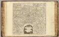
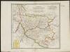
Guienne Orientale.
1 : 416000 Robert de Vaugondy, Gilles, 1688-1766
33) XI.N.O. ''Perigueux'', uit: Carte géologique de France
1 : 500000 Annotatie: Voor aanwezige bladen zie bladoverzicht [S.l : s.n.]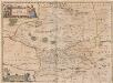
Le Comte de Perigort. [Karte], in: Novus atlas absolutissimus, Bd. 4, S. 185.
1 Karte aus Atlas Janssonius Offizin
Partie septentrionale du gouvernement général de la Guienne
1 Karte : Kupferdruck ; 46 x 57 cm Robert de Vaugondy; Delahaye G. et D. Robert de Vaugondy
Partie occidentale du Languedoc
1 Karte : Kupferdruck ; 11 x 15 cm Sebastian Cramoisy
PETROCORIVM COMITATVS | Vulgo | LA COMTEE [!] DE | PERIGORT
[Amsterdam : Joan Blaeu]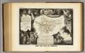
Dept. De Tarn et Garonne.
1 : 571000 Levasseur, Victor.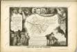


![[Cahors]](http://biblio.unibe.ch/web-apps/maps/zoomify.php?pic=Ryh_2304_25.jpg&col=ryh)

