Maps of Belgium
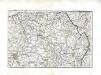
[Nordostfrankreich]
1 Karte : Kupferdruck ; 37 x 56 cm Chanlaire chez l'auteur P. G. Chanlaire rue Geoffroy-Langevin no. 7
Théatre de la guerre actuelle, en Allemagne, en Pologne et en Turquie. n9
1 : 900000 Chanlaire, Pierre Grégoire 1758-1817 Paris : chez l'auteur P. G. Chanlaire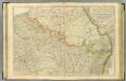
N. France.
1 : 680000 Faden, William, 1750?-1836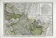
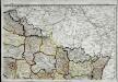
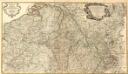
Deuxieme feuille contenant la Flandre francoise, Picardie, Artois, Isle de France, Champagne, Lorraine et Alsace
1 Blatt : 39 x 57 cm Bourgoin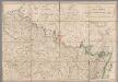
A map of the northern part of France to facilitate the knowledge of the operations carried out by the allied armies against the French Conventional troops
1 : 640000 London : William Faden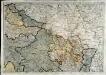
Neueste Generalkarte von Frankreich, 2
1 Blatt : 55 x 78 cm F.A. Schrämbl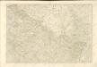
Carte de la république de France, no. 2
1 Blatt : 41 x 58 cm s.n.
Skizze zur Orientirung ϋber den Feldzug 1807

France Flle. N.E.
1 : 1000000 Vivien St Martin, L.
Allgemeine Uebersicht des Kriegsschauplazes am Rhein, der Mosel, Maas, Marne, Seine, Schelde [et].c.c
1 Karte : Kupferdruck ; 48 x 58 cm Güssefeld bey d. Homann. Erben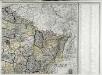
Carte de la France, 2
1 Blatt : 60 x 82 cm de Belleyme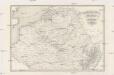
Kriegsschauplatz der Niederlande eines Theils von Holland und am Rhein
Nizozemsko Lehnhardt
Nordost Frankreich, Belgien und Luxemburg Deutsche Rheinländer
Frontieres de France et des Pais Bas
1 : 585000 Mollova mapová sbírka Fer, Nicolas de Fer, Nicolas de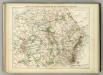
Carte Physique et Militaire de la Frontiere du Nord-Est.
1 : 1000000 Jouvet et Cie.
Flemmings Spezialkarte für den deutsch-französischen Krieg
1 : 600000 Evropa západní Carl Flemming
Zu den Feldzügen 1708 in den Niederlanden und am Rhein
Lille (Francie) Coxe, William K.k. Generalstabes
Les Provinces Apellées Pais Bas Connues Sous Les Noms De Flandre Et De Hollande
1 : 600000 Mollova mapová sbírka Fer, Nicolas de Loon, Herman van Fer, Nicolas de
Belgii sive Germaniae accuratissima tabula
Mollova mapová sbírka Hondius, Henricus Janssonius, Johannes I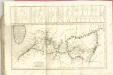

Netherlands, Germany W. of Rhine.
1 : 1620000 Darton, William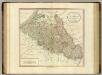
Netherlands, part of Germany.
1 : 880000 Cary, John, ca. 1754-1835
[104][107] Belgii Regii accuratissima tabula pluribus locis, uit: Atlas sive Descriptio terrarum orbis
Annotatie: Gedigitaliseerde versie. Amsterdam. Heiloo : Picturae (vervaardiger), 2015. tiff-bestand. Gedigitaliseerd: 07-01-2015; Origineel: Universiteitsbibliotheek Vrije Universiteit (XL.05127.-) ; Netherlands; Titelpagina ontbreekt Wit, Frederik de Amsterdam : Frederick de Wit

Belgii Regii accuratissima Tabula. [Karte], in: Novus atlas absolutissimus, Bd. 3, S. 25.
1 Karte aus Atlas Janssonius Offizin
Belgii regii tabula
1 : 822000 Belgie Visscher, Nicolaes Jansz. per Nicolaum Visscher
Germania inferioris sive Belgii pars meridionalis exhibens X. provincias catholic. cum confiniis Galliae Germ. Hollandiae
Belgie Pinas, Carl Graf Vasquez Lotter, Tobias Conrad Tob. Conr. Lotter

![[Nordostfrankreich]](http://biblio.unibe.ch/web-apps/maps/zoomify.php?pic=Ryh_2608_21.jpg&col=ryh)

