Maps of Douai

Plan tres exact des environs de Douay, Lens, Ecluse, et Arleux
1 Karte : Kupferdruck ; 38 x 50 cm Rotterdam by Pieter Rotterdam boekverkoper op de Vygendam
Doway a strong city in the earldom of Flanders in the Low countries : subject fo the french : plan of the city of Doway / J. Basire sculp
Basire, J.
DVACVM; Vulgo | DOUAY
[Amsterdam : Joan Blaeu]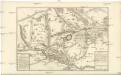
Carte Tres particuliere des Environs de Douay ou L'on voit les Lignes de Circonvalation, Comme aussy l'Innondation faite par la Scarpe
1 : 93000 Douai (Francie) Fricx, Eugene Henry Harrewyn, Jacques chez Eugene Henry Fricx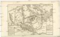
Carte Tres particuliere des Environs de Douay ou L'on voit les Lignes de Circonvalation, Comme aussy l'Innondation faite par la Scarpe
1 : 93000 Douai (Francie) Fricx, Eugene Henry Harrewyn, Jacques chez Eugene Henry Fricx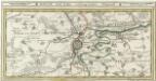
Douay Mitt Nahe anliegender Gegend.
1 : 130000 Mollova mapová sbírka Bodenehr, Gabriel Bodenehr, Gabriel
Map showing progress in Arras area
1 : 40000 First World War map showing progress in Arras area. War Office
France Sheet 36c. 3rd ed. 'For Indian Contingent'
1 : 40000 First World War map of France Sheet 36c. 3rd ed. 'For Indian Contingent'. Place names in English and Hindi. War Office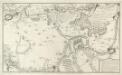
Plan des Retranchemens et du Camp de Denain, ou est marqué :
1 : 60000 Mollova mapová sbírka Fer, Nicolas de Fer, Nicolas de
Carte Particuliere des Environs de Lille Tournay, Valenciennes, Bouchain, Douay, Arras, Bethune
1 : 116600 Mollova mapová sbírka Fricx, Eugène Henry Covens, Johannes I
Carte particuliere des environs de Lille, Tournay, Valenciennes, Bouchain, Douay, Arras, Bethune
1 : 116600 Mollova mapová sbírka Fricx, Eugène Henry Harrewyn, Jacques Fricx, Eugené Henry
Archiepiscopatvs Cameracensis
1 Karte : Kupferdruck ; 37 x 48 cm Blaeu apud Guiljelmum Blaeuw
L'archevesche de Cambray
1 Karte : Kupferdruck ; 35 x 48 cm Tavernier; Hondius imprimé ches Henrÿ Hondius, ches Melchior Tavernier aupres du palais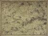
Carte particuliere des environs de Lille, Tournay, Valenciennes, Bouchain, Douay, Arras, Bethune
1 Karte : Kupferdruck ; 40 x 55 cm Fricx; Harrewijn chez Eugene Henry Fricx ruë de la Madelene
Carte particuliere des environs de Lille, Tournay, Valenciennes, Bouchain, Douay, Arras, Bethune
1 : 110000 Arras (Francie) Fricx, Eugene Henry Harrewyn, Jacques chez Eugene Henry Friex
GALLOFLANDRIA, | in qua CASTELLANIÆ | LILANA, DVACENA, & ORCHIESIA, cum dependentibus; | necnon TORNACVM, & TORNACESIVM
Auctore Martino Doué Gallo-Flandro. Guiljelmus Blaeu excudit.
Flandriae Comitatus Pars Australis
1 : 133000 Mollova mapová sbírka Visscher, Nicolaes Schenk, Peter II
Flandriae comitatus pars Australis, in Castellaniam insulanam, Balliviatum duacensem, territorium Tornacensem, et in suasquasque ditiones subjacentes
1 : 140000 accuratissima divisa per Nicolaum Visscher Amst. Bat. Amst. Bat. : per Nicolaum Visscher
Le Diocese De Tournay ou font Exactement Marquées Les Lignes Levé & Gravé Par Ordre Expres Du Roy [...] [Karte], in: Atlas nouveau, contenant toutes les parties du monde [...], Bd. 2, S. 52.
1 Karte aus Atlas Sanson, Nicolas Jaillot, Alexis Hubert und Mortier, Pieter
Arcihiepiscopatus Cameracensis ; Archevesche de Cambray
1 : 59000
Gallo Flandria, in qua Castellaniae Lilana, Duacena, & Archiesia, cum dependentibus; neenon Tornacum,& Tornacesium. [Karte], in: Novus Atlas, das ist, Weltbeschreibung, Bd. 1, S. 368.
1 Karte aus Atlas Blaeu, Joan Blaeu, Willem Janszoon
La Flandre gallicane conquise par le roy
1 Karte : Kupferdruck ; 42 x 38 cm Duval chez l'auteur proche le palais sur le quay de l'Orloge proche la ruë de Harlay
La chatellenie de Lille et le bailliage de Tournay
1 Karte : Kupferdruck ; 57 x 48 cm Le Rouge G. Le Rouge rue des grands Augustins vis avis le panier Fleury
Galloflandria, in qua Castellaniae Lilana, Duacena, & Orchiesia, cum dependentibus; neenon Tornacum,& Tornacesium. [Karte], in: Theatrum orbis terrarum, sive, Atlas novus, Bd. 1, S. 381.
1 Karte aus Atlas Blaeu, Joan Blaeu, Willem Janszoon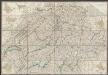
Gallo Flandria, in qua Castellaniae Lilana, Duacena, & Orchiesia, cum dependentibus; necnon Tornacum, & Tornacesium. [Karte], in: Le théâtre du monde, ou, Nouvel atlas contenant les chartes et descriptions de tous les païs de la terre, Bd. 1, S. 397.
1 Karte aus Atlas Blaeu, Willem Janszoon und Blaeu, Joan Blaeu, Willem Janszoon
ARCHIEPISCOPATVS | CAMERACENSIS. | Archevesché de | CAMBRAY
AMSTERDAMI | Apud Guiljelmum Blaeuw
Archiepiscopatus Cameracensis. Archevesché de Cambray. [Karte], in: Theatrum orbis terrarum, sive, Atlas novus, Bd. 2, S. 41.
1 Karte aus Atlas Blaeu, Joan Blaeu, Willem Janszoon
Arcihiepiscopatus Cameracensis. Archevesche de Cambray. [Karte], in: Novus atlas absolutissimus, Bd. 3, S. 150.
1 Karte aus Atlas Janssonius Offizin
L'Archevesche de Cambray [Karte], in: Gerardi Mercatoris et I. Hondii Newer Atlas, oder, Grosses Weltbuch, Bd. 2, S. 26.
1 Karte aus Atlas Mercator, Gerhard und Hondius, Jodocus Jansson, Jan


