Maps of Dunkirk

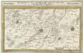
Carte du département du Nord ou les provinces de Flandre du Hainaut et du Cambresis, 1
1 Blatt : 47 x 58 cm s.n.
Fiandra Parte Occidentale
1 : 300000 Mollova mapová sbírka Coronelli, Vincenzo Maria Padoani, Domenico
Fiandra Parte Occidentale
1 : 300000 Mollova mapová sbírka Coronelli, Vincenzo Maria Padoani, Domenico
Calais 81, uit: Special-Karte von Mittel-Europa / nach amtlichen Quellen bearbeitet von W. Liebenow
1 : 300000 titelvariant: W. Liebenow's Mittel-Europa; Annotatie: Titel boven de bladen: W. Liebenow's Mittel-Europa Johannes Wilhelm Liebenow 1822-1897 Frankfurt a. M. : Ludwig Ravenstein
Calais 81, uit: [W. Liebenow's Special-Karte von Mittel-Europa]
1 : 300000 titelvariant: W. Liebenow's Mittel-Europa; Annotatie: Titel boven de bladen: W. Liebenow's Mittel-Europa Johannes Wilhelm Liebenow 1822-1897 Hannover : Hermann Oppermann
Tabula Comitatvs Artesiae
1 : 200000 Mollova mapová sbírka Wit, Frederik de Wit, Frederick
Flandriae Pars Occidentalis [...] [Karte], in: Novus atlas absolutissimus, Bd. 3, S. 115.
1 Karte aus Atlas Janssonius Offizin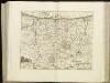
[108][111] Pars Flandriae occiden[talis] ..., uit: Atlas sive Descriptio terrarum orbis
Annotatie: Gedigitaliseerde versie. Amsterdam. Heiloo : Picturae (vervaardiger), 2015. tiff-bestand. Gedigitaliseerd: 07-01-2015; Origineel: Universiteitsbibliotheek Vrije Universiteit (XL.05127.-) ; Netherlands; Titelpagina ontbreekt Wit, Frederik de Amsterdam : Frederick de Wit
IPRENSIS | Episcopatus
Ioh. Blaeu excud.
Kriegsgeologische Uebersichtskarte für den Stellungsbau : Zusammendruck für die 4. Armee
1 : 20000 Relief shown by spot heights and hachures. War Geological overview map of the fortifications. "Stand der Erkundung: 1. September 1918." " ... am 12.9.18." "Lfd. Nr. 3297." Germany. Heer. Stoverm IV. Geologengruppe.; Germany. Heer. Vermessungs-Abteilung 24. Germany : Gruppen-Kartenstelle II, Verm. Abtlg. 24
Map of water supply: Hazebrouck
1 : 100000 Series of maps on water supplies. 2nd Army area water supply. Secret. Hazebrouck War Office
DITIO CASLETANA IN COMITATU FLANDRIÆ Vulgó Cassel Ambacht
Vedastus du Plouich invenit et fecit Amstelodami | Sumtibus Henrici Hondy
XI [Annonce de l'ouvrage], uit: Carte chorographique des Pays-Bas Autrichiens / ... par le Comte de Ferraris ; gravée par L.A. Dupuis
1 : 86400 Annotatie: Lit.: Les militaires et la cartographie des Pays-Bas méridionaux et de la Principauté de Liège à la fin du XVIIe et au XVIII siècle / Claire Lemoine-Isabeau. - Bruxelles, 1984, p. 206-212; La cartographie au XVIIIe siècle et l'oeuvre du Comte de Ferraris (1726-1814) : colloque international, Spa, 8-11 sept. 1976. - Bruxelles, 1978; Met opdracht aan keizer Joseph II (bl.XVI); Met plattegrond van Brussel (bl. XXI), overzichtskaart (bl. XXII) en bladwijzer (bl. XXIII); Ontbreekt: bl. I-III en XXI; Voor aanwezige bladen zie overzichtsblad Ferraris, Johann Joseph; Dupuis, L. A. [S.l. : s.n.]
Flandriae Comitatus pars occidentalis
1 : 133000 Mollova mapová sbírka Visscher, Nicolaes Schenk, Peter II
Flandriae pars occidentalis
1 : 185000 Belgie Hondius, Henricus sumptibus Henrici Hondii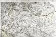
[Saint-Omer]
1 Blatt : 60 x 91 cm s.n.
Lille La Bassée
5 Saint-Omer.
1 : 86400 Cassini family; Cassini, Cesar-Francois, 1714-1784
NOVA ET EXACTA TABVLA GEOGRAPHICA SALÆ ET CASTELLANIÆ IPRENSIS. De Casselrie van Ipre. LA CHASTELENIE D'IPRE. ANNO M DC XXXXI
Vedastus du Plouich fec. Henricus Hondius excudebat
Boloniensis comitatvs
1 Karte : Kupferdruck ; 15 x 20 cm Lambert Andreae
Flandriae Comitatus Pars Australis
1 : 133000 Mollova mapová sbírka Visscher, Nicolaes Schenk, Peter II
Gallo Flandria, in qua Castellaniae Lilana, Duacena, & Archiesia, cum dependentibus; neenon Tornacum,& Tornacesium. [Karte], in: Novus Atlas, das ist, Weltbeschreibung, Bd. 1, S. 368.
1 Karte aus Atlas Blaeu, Joan Blaeu, Willem Janszoon
Carte particuliere des environs d'Arthois du Boulenois et d'une partie de la Picardie
1 : 110000 Artois (Francie) Fricx, Eugene Henry Harrewyn, Jacques chez Eugene Henry Friex
Carte Particuliere des Environs d'Artois du Boulenois et dune partie de la Picardie
1 : 116600 Mollova mapová sbírka Fricx, Eugène Henry Harrewyn, Jacques Fricx, Eugené Henry
Galloflandria
1 : 170000 Douai (Francie) Doué, Martin Blaeu, Willem Janszoon Guiljelmus Blaeu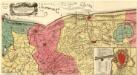
Perfecte Kaerte van t'Berger en Broucborger Ambacht, mitsgaders de Wateringen ende de Vier Dycken
Mollova mapová sbírka Visscher, Nicolaes Schenk, Peter II.
Perfecte Kaerte van t'Berger en Broucborger Ambacht, mitsgaders de Wateringen ende de Vier Dycken
1 : 90000 Mollova mapová sbírka Visscher, Claes Jansz. Visscher, Claes Janszoon
Carte particuliere des environs de Lille, Tournay, Valenciennes, Bouchain, Douay, Arras, Bethune
1 : 116600 Mollova mapová sbírka Fricx, Eugène Henry Harrewyn, Jacques Fricx, Eugené Henry
Carte particuliere des environs de Lille, Tournay, Valenciennes, Bouchain, Douay, Arras, Bethune
1 Karte : Kupferdruck ; 40 x 55 cm Fricx; Harrewijn chez Eugene Henry Fricx ruë de la Madelene