Maps of Vervins

Veromandvorvm comitatvs
1 Karte : Kupferdruck ; 14 x 18 cm Lambert Andreae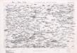
Map of water supply: St Quentin and part of Amiens
1 : 100000 Series of maps on water supplies. St Quentin and part of Amiens. War Office
Map of water supply: St Quentin
1 : 100000 Series of maps on water supplies. St Quentin. War Office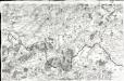
[Laon - Noyon]
1 Blatt : 60 x 91 cm s.n.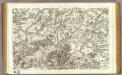
43 Laon, Noyon.
1 : 86400 Cassini family; Cassini, Cesar-Francois, 1714-1784
Descriptio Veromandvorvm
2 Karten auf 1 Blatt : Kupferdruck ; je 38 x 25 cm Janssonius; Surhon; Surhon; Petit Joannes Janssonius
Descriptio Veromandvorvm
2 Karten auf 1 Blatt : Kupferdruck ; je 38 x 25 cm Valck; Schenk; Surhon; Surhon; Petit apud G. Valk et P. Schenk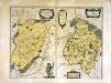
Descriptio Veromandvorvm
2 Karten auf 1 Blatt : Kupferdruck ; je 38 x 25 cm Blaeu; Blaeu; Surhon; Surhon; Petit apud Guiljelmum et Joannem Blaeuw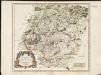
Evesché de Laon, ou sont les Duché, et Pairrie de Laon, Balliages de Laon, et Ribemont, Eslections de Laon, et de Guise etc.
1 : 211000
Veromandvorvm eorvm qve confinivm exactissima descriptio
1 Karte : Kupferdruck ; 34 x 21 cm Ortelius; Surhon; Surhon s.n.
Veromandvorvm eorvm qve confinivm exactissima descriptio
1 Karte : Kupferdruck ; 34 x 21 cm Ortelius; Surhon; Surhon s.n.
Vermandois
1 Karte : Kupferdruck ; 35 x 48 cm Tavernier; Hondius imprime chez Henry Hondius demeurant sur le Dam a l'enseigne du grand atlas, chez Melchior Tavernier demeurant sur l'isle du Palais a la sphere
Gouvernement de la Cappelle [Karte], in: Novus atlas absolutissimus, Bd. 4, S. 60.
1 Karte aus Atlas Janssonius Offizin
Gouvernement de la Cappelle [Karte], in: Theatrum orbis terrarum, sive, Atlas novus, Bd. 2, S. 35.
1 Karte aus Atlas Blaeu, Joan Blaeu, Willem Janszoon
Gouvernement de la Cappelle [Karte], in: Novus Atlas, das ist, Weltbeschreibung, Bd. 2, S. 33.
1 Karte aus Atlas Blaeu, Joan Blaeu, Willem Janszoon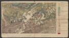
Descriptio Veromanduorum [...] Gallice Vermandois. [Karte], in: Le théâtre du monde, ou, Nouvel atlas contenant les chartes et descriptions de tous les païs de la terre, Bd. 2, S. 32.
1 Karte aus Atlas Blaeu, Willem Janszoon und Blaeu, Joan Blaeu, Willem Janszoon
Gouvernement de la Cappelle [Karte], in: Le théâtre du monde, ou, Nouvel atlas contenant les chartes et descriptions de tous les païs de la terre, Bd. 2, S. 33.
1 Karte aus Atlas Blaeu, Willem Janszoon und Blaeu, Joan Blaeu, Willem Janszoon
[left] DESCRIPTIO | VEROMANDVORVM | [-] | Gallice | VERMANDOIS; [right] GOVVERNEMENT | de la | CAPPELLE
[left] Auctore Ioanne Surhonio; [right] par P. petit Bourbon Amsterdami | Apud Guiljelmum | et Joannem Blaeuw
Descriptio Veromanduorum [Karte], in: Theatrum orbis terrarum, sive, Atlas novus, Bd. 2, S. 34.
1 Karte aus Atlas Blaeu, Joan Blaeu, Willem Janszoon

Descriptio Veromanduorum [...] Gallice Vermandois. [Karte], in: Novus Atlas, das ist, Weltbeschreibung, Bd. 2, S. 32.
1 Karte aus Atlas Blaeu, Joan Blaeu, Willem Janszoon
[Mézières - Sedan]
1 Blatt : 59 x 91 cm Chalmandrier; Le Roy s.n.
Carte particuliere des environs d'Avesnes Landrecy, la Capelle, Guise
1 Karte : Kupferdruck ; 40 x 54 cm Fricx chez Cóvens et Mortier
Carte particuliere des environs d'Avesnes Landrecy, la Capelle, Guise
1 : 116600 Mollova mapová sbírka Fricx, Eugène Henry Covens, Johannes I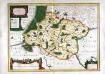
Description du gouvernement de la Cappelle
1 Karte : Kupferdruck ; 35 x 48 cm Petit; Hondius Henricus Hondius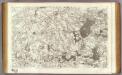
42 Cambrai.
1 : 86400 Cassini family; Cassini, Cesar-Francois, 1714-1784
Laon-West
1 : 50000 Pikardie (Francie) Vermessungs-Abteilung 26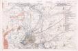
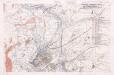
Defence of Hindenburg line no.2
1 : 20000 First World War map of defence of Hindenburg line. German artillery positions. From captured German maps dated 10-2-17. Sheet 62b SW. War Office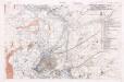
Defence of Hindenburg line no.5
1 : 20000 First World War map of defence of Hindenburg line. German artillery positions. From captured German maps dated 10-2-17. Sheet 62b SW. War Office