Maps of Bourges
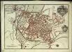
Plan de la ville et des fauxbourgs de Bourges capitale de la province de Berri
1 Plan : Kupferdruck ; 23 x 33 cm Fer Nicolas de Fer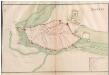
Bourges
A colored manuscript plan of the fortifications of the town of Bourges, France; drawn about 1650.
Govvernement de Bourges
1 Karte : Kupferdruck ; 11 x 15 cm Sebastian Cramoisy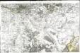
[Bourges]
1 Blatt : 60 x 91 cm Le Roy s.n.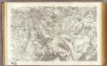
10 Bourges.
1 : 86400 Cassini family; Cassini, Cesar-Francois, 1714-1784
Bourges 151, uit: [W. Liebenow's Special-Karte von Mittel-Europa]
1 : 300000 titelvariant: W. Liebenow's Mittel-Europa; Annotatie: Titel boven de bladen: W. Liebenow's Mittel-Europa Johannes Wilhelm Liebenow 1822-1897 Hannover : Hermann Oppermann
Bourges 151, uit: Special-Karte von Mittel-Europa / nach amtlichen Quellen bearbeitet von W. Liebenow
1 : 300000 titelvariant: W. Liebenow's Mittel-Europa; Annotatie: Titel boven de bladen: W. Liebenow's Mittel-Europa Johannes Wilhelm Liebenow 1822-1897 Frankfurt a. M. : Ludwig Ravenstein
Diocese de l'archevesche de Bourges
1 : 211000
Département du Cher
1 Karte : Kupferdruck ; 56 x 40 cm Houdan; Dumez chez Dumez directeur de l'atlas national de France rue de la Harpe n.o 26
Département du Cher
1 : 265000 Cher (Francie) Houdan, François d' P. G. Chanlaire et Dumez
Département de l'Indre
1 Karte : Kupferdruck ; 34 x 41 cm Capitaine s.n.

Dept. De Cher.
1 : 563000 Levasseur, Victor.
Description du Blaisois anno 1630
1 Karte : Kupferdruck ; 36 x 48 cm Mercator; Hondius Henricus Hondius
Département du Cher
1 Karte : Kupferdruck ; 41 x 34 cm Capitaine s.n.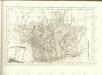

Carte Du Païs et Duchè de Nivernois [Karte], in: Novus atlas absolutissimus, Bd. 4, S. 200.
1 Karte aus Atlas Janssonius Offizin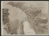
Carte Du Païs et Duchè de Nivernois [Karte], in: Gerardi Mercatoris et I. Hondii Newer Atlas, oder, Grosses Weltbuch, Bd. 2, S. 89.
1 Karte aus Atlas Mercator, Gerhard und Hondius, Jodocus Jansson, Jan
Nivernium Ducatus, Gallicè Duche De Nevers. [Karte], in: Novus Atlas, das ist, Weltbeschreibung, Bd. 2, S. 100.
1 Karte aus Atlas Blaeu, Joan Blaeu, Willem Janszoon
Description du Blaisois
1 Karte : Kupferdruck ; 35 x 47 cm Valck; Schenk typographia Gerardi Valk et Petri Schenk
Nivernium Ducatus, Gallicè Duche De Nevers. [Karte], in: Theatrum orbis terrarum, sive, Atlas novus, Bd. 2, S. 99.
1 Karte aus Atlas Blaeu, Joan Blaeu, Willem Janszoon
Nivernium Ducatus, Gallicè Duche De Nevers. [Karte], in: Le théâtre du monde, ou, Nouvel atlas contenant les chartes et descriptions de tous les païs de la terre, Bd. 2, S. 98.
1 Karte aus Atlas Blaeu, Willem Janszoon und Blaeu, Joan Blaeu, Willem Janszoon

Ambivareti in Aeduis, ubi postea Vadicasses, Evesché de Nevers
1 : 210000
La generalité de Paris, 3
1 Blatt : 68 x 52 cm chez l'auteur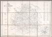
Carte du Département de l'Indre / Ad. Appé et E. Robin del.
1 : 200000 Appé, Ad.; Robin, E. Châteauroux : Nuret
Senones
1 Karte : Kupferdruck ; 39 x 50 cm Sanson; Robert de Vaugondy; Lebeuf chés le Sr. Robert geog. ord. du roy sur le quay de l'horloge du palais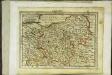
Biturigum ducatus
1 Karte : Kupferdruck ; 17 x 24 cm Mercator; Keere Cloppenburgh


