Maps of Pas-de-Calais

Artesia cum finitimis locis velut sedes ac theatrum belli
1 Karte : Kupferdruck ; 48 x 57 cm Lotter; L'Isle Tobias Konrad Lotter
Artesia cum finitimis locis velut sedes ac theatrum belli
1 Karte : Kupferdruck ; 47 x 56 cm Seutter; L'Isle Matthäus Seutter
Nouvelle carte d'Artois et des environs
1 Karte : Kupferdruck ; 47 x 59 cm L'Isle; Husson; Anse chez Pierre Husson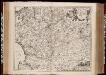
Geographica Artesiae Comitatus tabula / per Nicolaum Visscher edita
1 : 180000 Annotatie: Origineel is Blad 35 in atlas factice; Annotatie geografische gegevens: Met 2 schaalstokken; Legenda Nicolaes Jansz Visscher sr 1618-1679 [Amsterdam : Nicolaes Visscher]

Carte d'Artois et des environs
1 Karte : Kupferdruck ; 47 x 59 cm L'Isle chez Iean Cóvens et Corneille Mortier
Carte d'Artois, et des environs
1 Karte : Kupferdruck ; 48 x 60 cm L'Isle; Berey chez l'auteur sur le quai de l'Horloge a l'aigle d'or
Artois. Atrebatum Regionis Vera Descriptio. [Karte], in: Theatrum orbis terrarum, S. 183.
1 Karte aus Atlas Ortelius, Abraham Vrients, Jan Baptista
Artois. Atrebatum Regionis Vera Descriptio. [Karte], in: Theatrum orbis terrarum, S. 117.
1 Karte aus Atlas Ortelius, Abraham
Novissima Artesiæ comitatus tabula
1 Karte : Kupferdruck ; 48 x 55 cm Danckerts; Danckerts in lucem edita per Iustinum Danckerum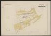
Artesia Comitatus. [Karte], in: Gerardi Mercatoris et I. Hondii Newer Atlas, oder, Grosses Weltbuch, Bd. 1, S. 431.
1 Karte aus Atlas Mercator, Gerhard und Hondius, Jodocus Jansson, Jan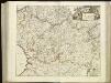
[110][113] Tabula Comitatus Artesiae, uit: Atlas sive Descriptio terrarum orbis
Annotatie: Gedigitaliseerde versie. Amsterdam. Heiloo : Picturae (vervaardiger), 2015. tiff-bestand. Gedigitaliseerd: 07-01-2015; Origineel: Universiteitsbibliotheek Vrije Universiteit (XL.05127.-) ; Netherlands; Titelpagina ontbreekt Wit, Frederik de Amsterdam : Frederick de Wit
Carte d'Artois et des environs
1 Karte : Kupferdruck ; 47 x 55 cm L'Isle Homännische Erben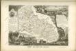

Tabula comitatvs Artesiæ
1 Karte : Kupferdruck ; 46 x 55 cm Wit ex officina I. Cóvens et C. Mortier
Tabula comitatvs Artesiæ
1 Karte : Kupferdruck ; 46 x 56 cm Wit bÿ Frederick de Wit inde Calverstraet bÿ den Dam inde witte paskaert
Artesia comitatvs
1 Karte : Kupferdruck ; 37 x 49 cm Blaeu apud Guiljelmum Blaeuw
Geographica Artesiae Comitatus Tabula [Karte], in: Novus atlas absolutissimus, Bd. 3, S. 141.
1 Karte aus Atlas Janssonius Offizin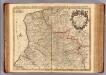
Artois, environs.
1 : 210000 L'Isle, Guillaume de, 1675-1726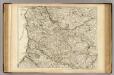
Artois, environs.
1 : 210000 L'Isle, Guillaume de, 1675-1726
Artesia, Comitatus. Artois. [Karte], in: Novus Atlas, das ist, Weltbeschreibung, Bd. 1, S. 351.
1 Karte aus Atlas Blaeu, Joan Blaeu, Willem Janszoon

ARTESIA, | COMITATVS. | ARTOIS.
Amsterdami | Apud Guiljelmu[m] Blaeuw.
Artesia, Comitatus Artois. [Karte], in: Novus atlas absolutissimus, Bd. 3, S. 138.
1 Karte aus Atlas Janssonius Offizin
Artesia, Comitatus. Artois. [Karte], in: Theatrum orbis terrarum, sive, Atlas novus, Bd. 1, S. 391.
1 Karte aus Atlas Blaeu, Joan Blaeu, Willem Janszoon
Artesia, Comitatus. Artois. [Karte], in: Le théâtre du monde, ou, Nouvel atlas contenant les chartes et descriptions de tous les païs de la terre, Bd. 1, S. 380.
1 Karte aus Atlas Blaeu, Willem Janszoon und Blaeu, Joan Blaeu, Willem Janszoon
ARTESIA, | COMITATVS. | ARTOIS.
Amsterdami | Apud Guiljelmu[m] Blaeuw.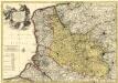
Le Comté d'Artois, et des Environs, ou l'on voit le Ressort du Conseil Provincial d'Artois avec les Frontieres de Picardie
1 : 250000 Mollova mapová sbírka Visscher, Nicolaes Schenk, Pieter Visscher, Nicolaus I.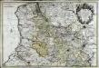
Carte d'Artois et des environs
1 Karte auf 2 Blättern : Kupferdruck ; 57 x 85 cm Mortier; Sanson; L'Isle chez Pierre Mortier


