Maps of Rhône-Alpes

Kriegstheater oder Grænzkarte zwischen Frankreich und Italien
1 Karte : Kupferdruck ; 48 x 58 cm Walch; Will zu haben bey Ioh. Walch im Willischen Kunstverlag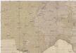
Kriegstheater oder Graenzkarte zwischen Frankreich und Italien
1 : 1025000 Francie jihovýchodní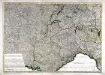
Kriegstheater oder Grænzkarte zwischen Frankreich und Italien
1 Karte : Kupferdruck ; 47 x 68 cm Müller; Artaria zufinden bey Artaria Compagnie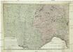
Kriegstheater oder Graenzkarte zwischen Frankreich und Italien
1 : 1025000 Francie jihovýchodní Müller, Franz Artaria
Das Festland Sardinien

Savoy.
from A new systeme of the mathematicks: containing I. Arithmetick, as well natural and decimal, as in species, or the principles of algebra. II. Practical geometry, together with the first six books of Euclid's Elements, as also the eleventh and twelfth, symbo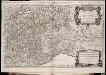
Les montagnes des Alpes ou sont remarqués les passages de France en Italie, le Duché de Milan, et les estats du duc de Savoye &c. / dressé sur les memoires les plus nouveaux par le Sr. Sanson ...
1 : 600000 Annotatie: Titel boven de kaart: Les montagnes des Alpes, ou sont remarqués les passages de France en Italie, le Duché de Milan, et les estats du duc de Savoye qui cõpreñent le Duché de Savoye et la Principauté de Piemont, &c; Avec privilège du Roy, pour 20 ans, 1676; Origineel is Blad 152 in atlas factice; Annotatie geografische gegevens: Met 6 schaalstokken A Paris : chez H. Iaillot
Geognostische Karte der Alpen in Savoyen und der Schweitz in einem Theile von Deutschland, Frankreich, Piemont und der Lombardei
1 : 1300000 1 Karte gez. von F. Schoedinger ; gest. von J. Scheurman [Orell, Füssli und Compagnie], [Zürich]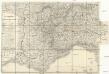
Strassen-Karte der westlichen Alpen
1 : 700000 Západní Alpy Oesterreichischen Generalquartiermeisterstabs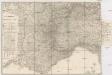
Strassen-Karte der westlichen Alpen
1 : 700000 Západní Alpy K. u. k. Militärgeographisches Institut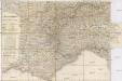
Strassen-Karte der westlichen Alpen
1 : 700000 Západní Alpy K. u. k. Militärgeographisches Institut
Geognostische Karte der Alpen in Savoyen und der Schweitz in einem Theile von Deutschland, Frankreich, Piemont und der Lombardei
1 : 1300000 1 Karte gez. von F. Schoedinger ; gest. von J. Scheurmann [Orell, Füssli und Compagnie?], [Zürich?]
Geognostische Karte der Alpen in Savoyen und der Schweitz in einem Theile von Deutschland, Frankreich, Piemont und der Lombardei
1 : 1300000 1 Karte gez. von F. Schoedinger ; gest. von J. Scheurman [Orell, Füssli und Compagnie], [Zürich]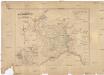
Das Festland Sardinien
1 : 1050000 Piemonte (Itálie) Joh. Prasch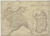
Charte des Koenigreichs Sardinien
1 : 1460000 Piemonte (Itálie) Mollo, Tranquillo bey Tranquillo Mollo
Charte des Koenigreichs Sardinien
1 : 1460000 Piemonte (Itálie) Mollo, Tranquillo bey Tranquillo Mollo
Les royau.mes de Bourgogne, et d'Arles
1 Karte : Kupferdruck ; 39 x 49 cm, Bildgrösse 40 x 56 cm Duval chez l'auteur en l'isle du Palais sur le quay de l'Orloge au coin de la rüe de Harlay
Carte de Suisse suivant sa nouvelle division en XVIII cantons formant la république helvétique
1 Karte in 2 Teilen auf 1 Bl. dressée par H. Mallet ; Emery sc. [chez F. Monty], [Genève]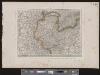
[Deutschland und der gröste Theil der umliegenden Staaten oder Mittel-Europa]
1 : 1100000 35 Karten [nach astronomischen Ortsbestimmungen und den besten Special-Karten, mit Rücksicht auf die neuesten Grenz-Bestimmungen entworfen, zufolge der Wiener Congress-Akte, des Pariser Friedens vom 21ten Nov. 1815, und der neuesten Austauschungen 1816 von H.H. Gotthold] ; [geschrieben und gestochen von H. Kliewer] ; sämtliche Gebürge im Atlas sind gezeichnet und gestochen von Paulus Schmidt, so wie auch die Sectionen 3,11,16,18,19,21,25,26,31 von demselben gestochen worden [Simon Schropp & Co.], [Berlin]
Helvetia
1 : 2500000 1 Karte [ed.: Giovanni Antonio Magini] [Petrus Keschedt], [In celeberrima Agrippinensium Colonia]
Carte de la Savoie ou supplément a la carte des frontières de la République française
1 Karte auf 2 Blättern : Kupferdruck ; 67 x 58 cm Delamarche; Dien; Goujon chez l'auteur rue du Foin St. Jacques
Switzerland
1 : 850000 1 Karte engraved by George Philip & Son Philip & Son, Liverpool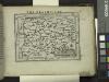
Delphinatus.
from Abraham Ortelius his epitome of the theater of the worlde / nowe latlye ... renewed and augmented ... by Micheal Coignet, mathematitian of Antwarpe.
Helvetiae descriptio
1 Karte Aegidio Tschudo auct. ; [Abraham Ortelius fecit] [en la emprenta de Roberto Bruneau?], [Anveres]
Théatre de la guerre en Italie ou le cours du Rhone
1 Karte : Kupferdruck ; 54 x 68 cm Poirson; Jean; Macquet; Tardieu chez Jean M.d d'estampes rue S. Jean de Beauvais n.o 4
Helvetia
1 : 2500000 1 Karte [ed.: Alphons Lasor a Varea] [Verlag nicht ermittelbar], [Patavii]
<<La>> Suisse avec les distances en lieues
1 : 2000000 1 Karte bey Hrch. Keller, Zürich
Karte der Militärkreise der Schweiz
Karte in französischer Sprache. Mit Erklärung der Farben und mit Übersichten der Truppenkontingente pro Kanton sowie des Generalstabs und der Divisionskommandanten.
Théatre de la guerre en Italie ou le cours du Rhone
1 Karte : Kupferdruck ; 54 x 68 cm Poirson; Jean; Macquet; Tardieu chez Jean M.d d'estampes rue S. Jean de Beauvais n.o 4
Status Mediolanensis, nec non ducatuum Mantuae, Modenae, Parmae ut et Genuensis reipublicae, suis cum finitimis dominiis accuratissima delineation
1 : 720000 Itálie severní Valk, Gerhard Gerald di Valck


