Maps of Grand Est

Kriegsschauplatz oder Graenzkarte zwischen Deutschland und Franckreich
1 Karte auf 2 Blättern : Kupferdruck ; 61 x 56 cm Walch zu haben bei Ioh. Walch im eignem Kunstverlag
Le Cours du Rhein
1 : 1100000 Mollova mapová sbírka Fer, Nicolas de Fer, Nicolas de
Theatrum Belli Serenissimae Domus Austriacae
1 : 410000 Mollova mapová sbírka Oettinger, Johann Friedrich Seutter, Matthäus
Theatrum Belli Serenissimae Domus Austriacae
1 : 410000 Mollova mapová sbírka Oettinger, Johann Friedrich Seutter, Matthäus
Theatrum Belli Serenissimae Domus Austriacae
1 : 410000 Mollova mapová sbírka Oettinger, Johann Friedrich Seutter, Matthäus
Theatrum Belli Serenissimae Domus Austriacae
1 : 410000 Mollova mapová sbírka Oettinger, Johann Friedrich Seutter, Matthäus
Theatrum Belli Serenissimae Domus Austriacae
1 : 410000 Mollova mapová sbírka Oettinger, Johann Friedrich Seutter, Matthäus
Theatrum Belli Serenissimae Domus Austriacae
1 : 410000 Mollova mapová sbírka Oettinger, Johann Friedrich Seutter, Matthäus
Carte des peuples riverains du Rhin au temps d’Auguste et de ses successeurs immédiats
Mitteleuropa Rhein-Gebiet ethnische Gruppe Germanen
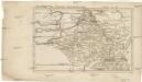
The Spanish Netherlands.
from A system of geography, or, A new & accurate description of the earth in all its empires, kingdoms and states : illustrated with history and topography, and maps of every country : fairly engraven on copper, according to the latest discoveries and corrections / by Herman Moll.
France

Unsere Westgrenze
1 : 1000000 Evropa západní Velhagen & Klasing
Belli ab obitu Caroli VI. Imperatoris usqve ad pacem Dresdae d. 25. Dec. MDCCXLV
1 : 1300000 Mollova mapová sbírka Kraus, Lorenz Jacob Homann, Johann Baptista - dědici
Bojište [sic] 1870
Belgie Bedřich Sandtner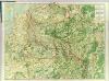
Map Western Front.
1 : 633600 C.S. Hammond & Company
Skizze zur Orientirung ϋber den Feldzug 1795
Belgica oder Nieder Teutschland
Belgie Baumgarten, Siegmund Jakob Johann Justinus Gebauer
D.O.M. Carte Generale Des Dixsept Provinces des Pays-Bas avec les Frontieres de France, d'Allemagne et Partie de l'Angleterre Nouvellement dreßée sur plusieur Momoires tirés sur les Lieux pendant les Guerres
1 : 750000 Mollova mapová sbírka Sengre, Henri Misson, François Maximilien
Descriptio Germaniae Inferioris. [Karte], in: Theatrum orbis terrarum, S. 162.
1 Karte aus Atlas Ortelius, Abraham Vrients, Jan Baptista
F. Handtke's Special-Karte vom Deutsch-Franz. Kriegsschauplatze
1 : 600000 Belgie Handtke, Friedrich C. Flemming
Europe Centrale (Partie Occidentale).
1 : 1750000 Jouvet et Cie.
[Recto], uit: Descriptio Germaniae Inferioris
1 : 1000000 Annotatie: Waarschijnlijk gegraveerd door F. Hogenberg; Uit: Theatrum Orbis Terrarm. - Antwerpen, 1570 Hogenberg, Franz [Antwerpen : Abraham Ortelius]
Descriptio Germaniae Inferioris. [Karte], in: Theatrum orbis terrarum, S. 42.
1 Karte aus Atlas Ortelius, Abraham
[Kaart], uit: Kaart der bevaarbare waterloopen van België, Nederland, N.-Frankrijk, W.-Duitschland, en den Rijn van Rotterdam tot Basel = Carte des voies navigables de la Belgique, la Hollande, N. de la France, Allemagne Est, et le Rhin de Rotterdam à Bâle = Wasserstrassen Karte von Belgien, Holland, N. Frankreich, W. Deutschland und der Rhein von Rotterdam bis Basel
1 : 800000 Antwerpen : Seghers
67-68. North-East France, Belgium, Luxemburg. The World Atlas.
1 : 1250000 USSR (Union of Soviet Socialist Republics).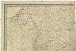
[Západní Evropa]
Belgie
[Západní Evropa]
Belgie
Frankreich. Upper right sheet
1 : 1200000 Geographisches Institut (Weimar, Germany)
Les Provinces Apellées Pais Bas Connues Sous Les Noms De Flandre Et De Hollande
1 : 600000 Mollova mapová sbírka Fer, Nicolas de Loon, Herman van Fer, Nicolas de


