Maps of Picardie
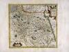
France, Picardie Champaigne
1 Karte : Kupferdruck ; 34 x 38 cm Mercator; Hondius Henricus Hondius
France, Picardie Champaigne
1 Karte : Kupferdruck ; 34 x 38 cm Hondius; Mercator Jodocus Hondius
France, Picardie Champaigne
1 Karte : Kupferdruck ; 34 x 37 cm Mercator s.n.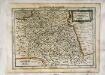
France, Picardie, Champaigne
1 Karte : Kupferdruck ; 18 x 24 cm Mercator Cloppenburgh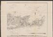
France Picardie Champaigne cum regionibus adiacentibus. [Karte], in: Gerardi Mercatoris Atlas, sive, Cosmographicae meditationes de fabrica mundi et fabricati figura, S. 232.
1 Karte aus Atlas Mercator, Gerhard Montanus, Petrus
Carte de France, 3
2 Blätter : Kupferdruck ; 54 x 45 cm Crepy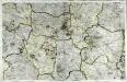
Carte de la France, no. 5
1 Blatt : 60 x 92 cm s.n.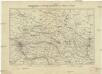
Special Karte des Kriegsschauplatzes von Metz bis Paris
1 : 1030000 Mety (Francie) Rachel, L. Verlag von Hermann Schönlein
Région Nord comprenant les XI departements du Nord de la France
1 Karte : Kupferdruck ; 53 x 46 cm Lotter; Lotter Lotter
Area bella gerentium in Gallia, et Belgio
1 Karte : Kupferdruck ; 46 x 58 cm Valck; Valck G. und L. Valck
1:500,000 Europe (Air) G.S.G.S. No. 4072, Paris
Sheet NE48-2 from the map series: 1:500,000 Europe (Air) G.S.G.S. No. 4072.
Carte des départemens de Paris, de la Seine et de l'Oise de la Marne de l'Aube, de la Haute Marne, et de la partie nord de celui d'Yonne
1 Karte : Kupferdruck ; 25 x 36 cm, Bildgrösse 31 x 41 cm Desnos; Starckman chés le S. Desnos ingénieur géog. rue St. Jacques au globe
Flemmings grosse Karte der Westfront-Nordhälfte : (Paris und Umgebung bis zur Nordsee) / red. von J.I. Kettler
1 : 320000 Kettler, J. I. Berlin : Flemming
Flemmings grosse Karte der Westfront - Nordhälfte
1 : 320000 Evropa západní Kettler, Julius Iwan Carl Flemming
Isle de France, Champagne, Lorraine [et]c
1 Karte : Kupferdruck ; 35 x 57 cm Sanson; Cordier chez l'autheur
Campaniæ præfectura divisum in electiones Rhemorum, Retelii, Catalauni, Augustibonæ, Longonæ, Chamontii, Meldarum, Senonarum
1 Karte : Kupferdruck ; 57 x 48 cm Valck; Valck edentibus Gerardo et Leonardo Valk
Gubernatio Insulæ Franciæ
1 Karte : Kupferdruck ; 46 x 59 cm Valck; Valck G. und L. Valck
[Paris
1 : 300000 Paříž-oblast (Francie) Kartogr. Abteilung der Stellvertretenden Generalstabes der Armee
Gouvernement General De Champagne. [...] [Karte], in: Atlas nouveau, contenant toutes les parties du monde [...], Bd. 1, S. 94.
1 Karte aus Atlas Sanson, Nicolas Jaillot, Alexis Hubert und Mortier, Pieter
Champaigne et Brie etc
1 Karte : Kupferdruck ; 39 x 49 cm Janssonius; Sanson Joannes Janssonius
Gouvernement de Champagne
1 Karte auf 4 Blättern : Kupferdruck ; 61 x 82 cm Mentelle; Tardieu Mentelle
Ile de France, Orleanois.
1 : 930000 Bonne, Rigobert, 1727-1794
Flle. 1. Mantes, uit: Carte topographique des environs de Versailles dite "Carte des chasses du Roi"
1 : 28800 titelvariant: Carte des chasses du Roi; Annotatie: Herdruk van originele koperplaten; Oorspr. uitg.: 1764-1807; Voor aanwezige bladen zie overzichtsblad; Annotatie geografische gegevens: Opname: 1764-1773 [Paris : IGN]
Champaigne et Brie
1 Karte : Kupferdruck ; 27 x 32 cm Merian Caspar Merian
Gouvernement general de Champagne
1 Karte auf 2 Blättern : Kupferdruck ; 76 x 53 cm Sanson; Jaillot chez Jean Cóvens et Corneille Mortier
Gouvernement general de Champagne
1 Karte auf 2 Blättern : Kupferdruck ; 76 x 53 cm Sanson; Jaillot chez H. Iaillot geographe ordinaire du roy proche les grands Augustins aux deux globes
Le Gouvernement General De L' Isle de France; ou la Generalité De Paris Divisée En Ses Eslections. [Karte], in: Atlas nouveau, contenant toutes les parties du monde [...], Bd. 1, S. 83.
1 Karte aus Atlas Sanson, Nicolas Jaillot, Alexis Hubert und Mortier, Pieter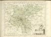
Composite 5: Carte de France.
1 : 86400 Cassini family; Cassini, Cesar-Francois, 1714-1784


