Maps of Cinca Medio

Carte du gouuernement de Monson
1 Karte : Kupferdruck ; 11 x 15 cm s.n.
Carte du gouuernement d'Algoire
1 Karte : Kupferdruck ; 11 x 15 cm s.n.
Plan of the country and camps of Almanar, the one under Charles III and the other of the Enemy under the D. of Anjou (July 27, 1710) / for Mr. Tindal's continuation of Mr. Rapin's History of England ; I. Basire sculp.
1 Mapa, b/n. Datat aproximadament al 1740. Tindal ; Rapin ; Basire, J.
Balaguer, een stad in Catalonia aen de Segre / P. Schenk exc. Amst.
1 Mapa, b/n. Setge de Balaguer el 23 agost de 1709 (territori entre Barbastre i Camarasa). Text en neerlandès i llatí. Datació aproximada. Schenk, Petrus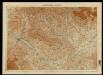
Zaragoza - Lerida
1 : 200000 1 Mapa. Carpeta:Zaragoza - Huesca. Datació aproximada.
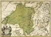
EPISCOPATUS | BALBASTRENSIS, | RIBAGORÇA COMIT. | et SOBRARBE, | Cum Adjacentibus
Auct. Joanne Baptista Labanna. AMSTELODAMI | Joannes Blaeu Excudit.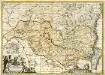
Episcopatus Balbastrensis et comitatus Ribagorcæ
1 Karte : Kupferdruck ; 36 x 51 cm Valck; Schenk apud Gerardum Valk et Petrum Schenk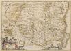
Episcopatus Balbastrensis et Comitatus Ribagorcae. [Karte], in: Novus atlas absolutissimus, Bd. 6, S. 64.
1 Karte aus Atlas Janssonius Offizin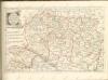
Episcopatus Oscensis descriptio
1 Karte : Kupferdruck ; 36 x 50 cm Valck; Schenk Gerard Valck und Pieter Schenk

45) XIV.N.O ''Bagneries de Luchon'', uit: Carte géologique de France
1 : 500000 Annotatie: Voor aanwezige bladen zie bladoverzicht [S.l : s.n.]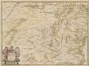
Episcopatus Oscensis Descriptio. [Karte], in: Novus atlas absolutissimus, Bd. 6, S. 58.
1 Karte aus Atlas Janssonius Offizin
EPISCOPATUS | OSCENSIS | Vulgo | HUESCA
Auct. I. Baptista Labanna [Amsterdam : Joan Blaeu]
Manuscrit: Corregimiento de Lerida
1 Mapa, col. + Text (55 fol.). Mapa ms. plegat dins: Descripsion del corregimiento de Lerida, 22 cm Darnius, comte de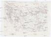
Contribution a la carte des Pyrénées espagnoles
1 : 200000 Pyreneje (Francie a Španělsko) Prudent, Ferdinand Institut cartographique
Carte du gouuernement de Lerida
1 Karte : Kupferdruck ; 11 x 15 cm s.n.
Carte du gouuernement d'Ager en Catalogne
1 Karte : Kupferdruck ; 11 x 15 cm s.n.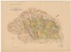
Canal d'Urgell / Facilitat per D. Joseph Bayer y Bosch ; A. Martin editor. Barcelona
1 : 200000 1 mapa. Datat entre 1910 i 1919 aproximadament.
Carte du gouuernement de Balaguier
1 Karte : Kupferdruck ; 11 x 15 cm s.n.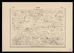
Mapa Geogràfic de Catalunya 1:100 000
1 : 100000 Prova d'impremta d'un full que no s'arribà a publicar. Datat entre 1920 i 1929 aproximadament. Servei Geogràfic de Catalunya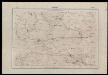
Mapa Geogràfic de Catalunya a escala 1:100 000
Minuta manuscrita a escala 50 000 d'un full que no s'arribà a publicar. Datat entre 1920 i 1929 aproximadament. Servei Geogràfic de Catalunya
Manuscrit: [El Segre i la xarxa de canals entre la confluència amb el Noguera Ribagorçana i Sudanell: plànol topogràfic de la zona compresa entre l'Alpicat, Lleida i el terme d'Artesa de Lleida]
1 : 10000 1 Mapa en fulls, manuscrit, col. & 4 fulls. Probablement, copiat cap a 1910 pel Servei Geogràfic de la Mancomunitat. - Sobre paper tela. - Full s.e.: De l'Alpicat a Rosselló; s.d.: de Benavent a Alcoletge; i.e.: de Sudanell a Albatàrrec; i.d.: Lleida.. - Datació aproximada.
Provincias de España: Lérida
1 : 500000 1 mapa, col. Provincias de España. - Dins cobertes. - Escut de la Diputació amb segell de tinta de la República española a sobre. Datat aproximadament al 1930. Chias Carbó, Benito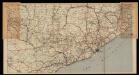
Mapa Michelin España en 13 hojas escala 1/400 000. full: Barcelona No 6
1 : 400000 Full d'una col·lecció. Datat entre 1920 i 1930. Michelin
Mapa de la provincia de Lérida
1 mapa. Fulletó de propaganda de l'editorial. Datat entre 1920 i 1929 aproximadament. Pompido, M.
Catalonia
1 : 1050000 Katalánsko (Španělsko) Blaeu, Willem Janszoon Guiljelmus Blaeu

ARRAGONIA | REGNVM
Auctore | Joanne Baptista Labanna. [Amsterdam : Joan Blaeu]
Regni Arragoniæ tÿpus novissimus, in episcopatus divisus
1 Karte : Kupferdruck ; 43 x 53 cm Wit ex officina I. Covens et C. Mortier
Le royaume d'Aragon
1 Karte : Kupferdruck ; 53 x 41 cm Nolin; Silva; Cantelli J. B. Nolin sur le quay de l'Horloge du Palais a l'enseigne de la place des Victoires
Il regno di Aragona
1 Karte : Kupferdruck ; 54 x 41 cm Cantelli; Rossi; Barbey Domenico de Rossi
Arragonia regnvm
1 Karte : Kupferdruck ; 40 x 50 cm Lavanha; Janssonius Joannes Janssonius
Royaume d'Arragon
1 Karte : Kupferdruck ; 40 x 36 cm Sanson s.n.
Novissima Arragoniæ regni tabula
1 Karte : Kupferdruck ; 43 x 53 cm Wit F. de Wit
Arragonia regnvm
1 Karte : Kupferdruck ; 40 x 50 cm Lavanha; Blaeu; Blaeu Joan und Cornelius Blaeu


