Maps of Galicia
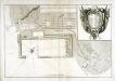
Mapa en plano del real arzenal del Ferrol
1 Plan : Kupferdruck ; 42 x 62 cm s.n.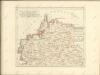
Mapa geográfico del reyno de Galicia, 1
2 Blätter : 41 x 85 cm s.n.
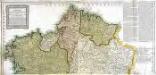
Charta geographica regnum Galæciam (hispanice Galicia) in suas provincias divisum repræsentans
1 Karte : Kupferdruck ; 44 x 52 cm Güssefeld; López per Homan. Hæredes in lucem edita
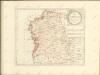
Gallæcia regnum
1 Karte : Kupferdruck ; 35 x 39 cm Mercator; Hondius Henricus Hondius
Gallicia
1 Karte : Kupferdruck ; 17 x 24 cm Mercator Cloppenburgh

Le royaume de Galice
1 Karte : Kupferdruck ; 43 x 47 cm Fer chez le Sr. de Fer dans l'isle du Palais sur le Quay de l'Orloge a la sphere royale

Gallæcia, regnvm
1 Karte : Kupferdruck ; 36 x 47 cm Ojea; Janssonius Joannes Janssonius
Gallæcia, regnvm
1 Karte : Kupferdruck ; 36 x 47 cm Ojea; Valck; Schenk apud Gerardum Valk et Petrum Schenk
Gallæcia, regnvm
1 Karte : Kupferdruck ; 37 x 49 cm Ojea; Blaeu apud Guilj. Blaeu
GALLÆCIA, | REGNVM
descripta a F. Fer. Ojea Ord. Præd. | et postmodum multis in locis | emendata et aucta Apud Guilj. Blaeu.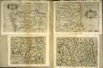
Galitia
1 Karte : Kupferdruck ; 15 x 23 cm Lambert Andreae
Gallaecia Regnum [Karte], in: Novus atlas absolutissimus, Bd. 6, S. 34.
1 Karte aus Atlas Janssonius Offizin
Gallaecia Regnum [Karte], in: Gerardi Mercatoris et I. Hondii Newer Atlas, oder, Grosses Weltbuch, Bd. 2, S. 189.
1 Karte aus Atlas Mercator, Gerhard und Hondius, Jodocus Jansson, Jan
Gallaecia, Regnum [...] [Karte], in: Le théâtre du monde, ou, Nouvel atlas contenant les chartes et descriptions de tous les païs de la terre, Bd. 2, S. 216.
1 Karte aus Atlas Blaeu, Willem Janszoon und Blaeu, Joan Blaeu, Willem Janszoon
Gallaecia, Regnum [Karte], in: Novus Atlas, das ist, Weltbeschreibung, Bd. 2, S. 225.
1 Karte aus Atlas Blaeu, Joan Blaeu, Willem Janszoon
Gallaecia, Regnum [Karte], in: Theatrum orbis terrarum, sive, Atlas novus, Bd. 2, S. 223.
1 Karte aus Atlas Blaeu, Joan Blaeu, Willem Janszoon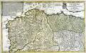
Le royaume de Galice divisé en plusieurs territoires, et les Asturies divisees en Asturie d'Oviedo et de Santillana
1 Karte auf 2 Blättern : Kupferdruck ; 43 x 71 cm Nolin; Rousseau; Silva; Julien chez le Sr. Julien a l'hotel de Soubise
Springfield, Sullivan Co.
1 : 47000 D.H. Hurd & Co.
[Carte d'Espagne et de Portugal en neuf feuilles, 1]
1 Blatt : 31 x 41 cm P.G. Chanlaire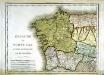
Espagne et Portugal, 1
1 Blatt : 31 x 42 cm Mentelle
Spain, Portugal 1.
1 : 1774080 Letts, Son & Co.
Regnorum Castellæ veteris Legionis et Gallæciæ principatuumque Biscaiæ et Asturiarum accuratissima descriptio, 1
1 Blatt : 48 x 41 cm Visscher
Spain. Espana I.
1 : 1800000 Society for the Diffusion of Useful Knowledge (Great Britain)

Portugal, Azoren, Capverdischen Inseln.
1 : 2350000 Radefeld, Carl Christian Franz, 1788-1874


