Maps of Almeida

Siege d'Almeida
1 Karte : Kupferdruck ; 23 x 23 cm Therbu; Cöntgen s.n.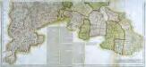
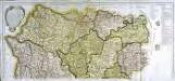
Mapa geografico de la provincia de Salamanca, 2
2 Blätter : 42 x 91 cm s.n.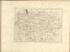
Mapa geografico de la provincia de Salamanca, 1
2 Blätter : 43 x 90 cm s.n.
Mapa geografica de la provincia de Salamanca, en que se distinguen sus partidos ... / por Tomas Lopez
1 : 200000 Annotatie: Met opdracht aan Joseph Alvarez de Toledo; Met toelichting op de kaart Lopez, Tomas Madrid : [Tomas Lopez]
Charta provinciam Salamanticam hispanice Salamanca, exhibens
1 Karte : Kupferdruck ; 44 x 53 cm Güssefeld; López in lucem edita per Homann. Hæredes
Mapa de la provincia, de Beira
1 Karte : Kupferdruck ; 33 x 30 cm López s.n.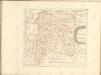

Mapa de la provincia de Tras-Los-Montes
1 Karte : Kupferdruck ; 32 x 27 cm López s.n.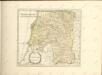

Mappa ou carta geographica dos reinos de Portugal e Algarve, 2
1 Blatt : 55 x 44 cm Dury
Mapa general del reyno de Portugal, 1
2 Blätter : 35 x 78 cm Tomás López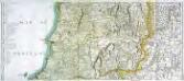
Mapa general del reyno de Portugal, 2
2 Blätter : 35 x 78 cm Tomás López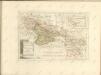


Estremadura con las nuevas divisiones
1 : 600000 formado por A. H. Dufour Paris : Bulla
Portugal septentrionale.
1 : 680000 Robert de Vaugondy, Gilles, 1688-1766
Partie septentrionale du royaume de Portugal
1 Karte : Kupferdruck ; 47 x 51 cm Robert de Vaugondy G. et D. Robert de Vaugondy
Il regno di Leone
1 Karte : Kupferdruck ; 55 x 41 cm Cantelli da Vignola; Rossi; Barbey dato in luce da Dom.co de Rossi erede di Gio. Giac.o de Rossi dalle sue stampe
[Carte d'Espagne et de Portugal en neuf feuilles, 4]
1 Blatt : 31 x 41 cm P.G. Chanlaire
Espagne et Portugal, 4
1 Blatt : 31 x 42 cm Mentelle
Carta de Portugal, aprovada para uso das escolas / Direccâo Geral dos Trabalhos Geodesicos e Topographicos
1 : 500000 Direcçâo Geral dos Trabalhos Geodesicos e Topographicos
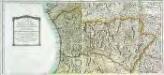
Regni Portugalliae provincias tres septentrionales Beiram, Transmontanam [et] Interamniam
1 Karte : Kupferdruck ; 53 x 44 cm Güssefeld; López Homann. haered
Parte septentrional do reyno de Portugal
1 Karte : Kupferdruck ; 40 x 52 cm Sanson em casa do autor
Portugal.
1 : 1300000 Hall, S. (Sidney)
Partie septentrionale du royaume de Portugal
1 Karte : Kupferdruck ; 47 x 52 cm Bellin; Santini; Remondini chez M. Remondini
Il Portogallo cioè le provincie di Entre Douro, e Minho, Traz-Os-Montes, e Beira
1 Karte : Kupferdruck ; 30 x 40 cm Zatta Antonio Zatta
Royaume de Portugal
1 : 7660000 Portugalsko Bonne, Rigobert André
Carta de Portugal
1 : 1500000 Portugalsko Instit. Geogr. e Cadastral


