Maps of Metropolitan France
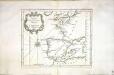
Carte des costes de France et d'Espagne
1 Karte : Kupferdruck ; 21 x 26 cm Bellin Arkstée et Merkus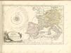

France.
from A new systeme of the mathematicks: containing I. Arithmetick, as well natural and decimal, as in species, or the principles of algebra. II. Practical geometry, together with the first six books of Euclid's Elements, as also the eleventh and twelfth, symbo
Western Europe.
1 : 7303000 Fisher, Richard Swainson
Western Europe.
1 : 6900000 Goodrich, S.G.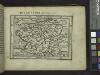
Gallia.
from Abraham Ortelius his epitome of the theater of the worlde / nowe latlye ... renewed and augmented ... by Micheal Coignet, mathematitian of Antwarpe.
Map of France, Spain, and Portugal; Switzerland in cantons [inset]; Island of Corsica [inset].
from Mitchell's new general atlas, containing maps of the various countries of the world, plans of cities, etc., embraced in fifty-three quarto maps., forming a series of eighty four maps and plans, together with valuable statistical tables.
Secunda Europe Tabula [Karte], in: [Clavdii Ptholomei Cosmographi ...], S. 248.
1 Karte aus Atlas Nicolaus Germanus [und Ptolemaeus, Claudius]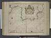
Paskaert van Spanjen, vertoonende de Kusten van Granade, Andaluzie, Algarve, Portugael, Galissen en Biscajen, met een gedeelte van Vranckrijck streckende van Heyssant tot de Straet van Gibralter.
from De zee-atlas ofte water-wereld : waer in vertoont werden alle de zee-kusten van het bekende des aerd-bodems : seer dienstigh voor alle heeren en kooplieden, als oock voor alle schippers en stuurlieden / by Pieter Goos.
France, Spain, and Portugal.
1 : 3650000 Johnson, A.J.
France, Spain, and Portugal.
1 : 3650000 Johnson, A.J.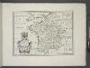
France, and parts adjoining.
from A new sett of maps both of antient and present geography : wherein not only the latitude and longitude of many places are corrected according to the latest observations, but also the most remarkable differences of antient and present geography may be quickly discern'd by a bare inspection or comparing of correspondent maps, which seems to be the most natural and easy method to lead young students (for whose use the work is principally intended) unto a competent knowledge of the geographical science : together with a geographical treatise particularly adapted to the use and design of these maps / by Edward Wells, M.A. and student of Christ-Church, Oxon.
[Jihozápadní Evropa]
1 : 5800000 Evropa jihozápadní
Tabula Europae II. [Karte], in: Geographia universalis vetus et nova complectens Claudii Ptolemaei Alexandrini enarrationis libros VIII, S. 225.
1 Karte aus Atlas Münster, Sebastian [und Ptolemaeus, Claudius]
Tabula Europae III. [Karte], in: Geographia universalis vetus et nova complectens Claudii Ptolemaei Alexandrini enarrationis libros VIII, S. 228.
1 Karte aus Atlas Münster, Sebastian [und Ptolemaeus, Claudius]
Tabula Europae III. [Karte], in: Claud. Ptolemaeus. Geographia lat. cum mappis [...], S. 260.
1 Karte aus Atlas Münster, Sebastian [und Ptolemaeus, Claudius]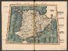
Tabula Secunda Europe [Hispania] [Karte], in: Claudii Ptolemei viri Alexandrini mathematice discipline philosophi doctissimi geographie opus [...], S. 154.
1 Karte aus Atlas Waldseemüller, Martin [und Ptolemaeus, Claudius] Übelin, Georg
Karten - Skizzen für die Schul - Praxis

Pas-Caart van Hispaengien vertoonende Custen van Granade, Andaluzie, Algarve Portugael, Galissen, en Biscajen [...] [Karte], in: De Nieuwe Groote Vermeerderde Zee-Atlas ofte Water-Werelt, S. 49.
1 Karte aus Atlas Doncker, Hendrick
Karte von Europa, 3
4 Blätter : 53 x 70 cm Verlag der Königlich-Preussischen Academie-Kunst- und Buchhandlung
Tabula Europae II. [Karte], in: Claud. Ptolemaeus. Geographia lat. cum mappis [...], S. 257.
1 Karte aus Atlas Münster, Sebastian [und Ptolemaeus, Claudius]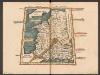
Tercia Europe Tabula [Gallia] [Karte], in: Claudii Ptolemei viri Alexandrini mathematice discipline philosophi doctissimi geographie opus [...], S. 157.
1 Karte aus Atlas Waldseemüller, Martin [und Ptolemaeus, Claudius] Übelin, Georg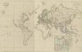
XI. Charte für die allgemeine Geschichte von der Selbstregierung Ludwig XIV. bis auf den österreichischen Erbfolgekrieg : d.i. von 1661 bis 1740 n. Christus
Entworfen von F.W. Benicken A. Falger gr. Weimar : im Verlage des L. Industrie-Comptoirs
Imperium Romanum
1 : 11100000 Evropa západní Bonne, Rigobert
Mapa de España y Portugal: dividido en sus actuales provincias y orlado con los de las posesiones ultramarinas españolas y los planos de las principales ciudades
1 : 800000 . Conté 3 mapes: Islas Canarias, Islas Antillas, Islas Filipinas; i 8 plantes de ciutats: S. Sebastián, Sevilla, La Habana, Madrid, Palma, Zaragoza, Valencia, Barcelona. - Fotografia: T-VI-1-17698 Martín de López, Pedro; Alabern, Ramon Gaspar y Roig
[Ethnographische Karte von Europa]
Zweiter Band, enthaltend in vier Abtheilungen die Vertheilung der Organismen: 5. Pflanzen-Geographie, 6. Thier-Geographie, 7. Anthropographie, 8. Ethnographie Humboldt, Alexander von Verlag von Justus Perthes
Orbis Romani pars occidentalis, auspiciis serenissimi principis Ludovici Philippi Aurelianorum ducis publici juris facta
1 : 4300000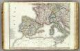
Europe 3.
1 : 3850000 Brue, Adrien Hubert, 1786-1832
Západní Evropa při konci XIV. věku


