Maps of Europe
Nova Europæ descriptio
1 Karte : Kupferdruck ; 36 x 48 cm Hondius; Hondius Jodocus Hondius excudit
Nova Europæ descriptio
1 Karte : Kupferdruck ; 35 x 48 cm Hondius Jodocus Hondius excudit
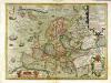
Evropa
1 Karte : Kupferdruck ; 38 x 46 cm Mercator; Mercator; Hondius Henricus Hondius
Evropa
1 Karte : Kupferdruck ; 38 x 46 cm Mercator; Mercator; Hondius Henricus Hondius?
Evropa
1 Karte : Kupferdruck ; 38 x 46 cm Mercator; Mercator; Hondius Jodocus Hondius
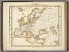
Europa
1 Karte : Kupferdruck ; 47 x 55 cm Walch Johann Walch
Europa
1 Karte : Kupferdruck ; 21 x 26 cm Reilly Franz J. J. von Reilly
Europa
E. von Sydow's Schul-Atlas in sechs und dreissig Karten Sydow, Emil von bei Justus Perthes
Europa
1 : 30000 Evropa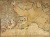
Nouvelle carte des decouvertes faites par des vaisseaux russiens aux côtes inconnues de l'Amerique septentrionale avec les pais adiacents
1 Karte auf 2 Blatt : Kupferdruck ; 44 x 62 cm Rey; Schenk chez Marc Michel Rey
Europa
1 Karte : Kupferdruck ; 47 x 55 cm Walch Johann Walch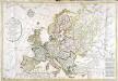
Carte générale de l'Europe
1 Karte : Kupferdruck ; 52 x 75 cm Hérisson; Basset; Basset chez Basset rue Jacques au coin de celle des Mathurins no. 670
Moscovia.
from A new systeme of the mathematicks: containing I. Arithmetick, as well natural and decimal, as in species, or the principles of algebra. II. Practical geometry, together with the first six books of Euclid's Elements, as also the eleventh and twelfth, symbo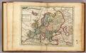
Europe.
1 : 29000000 Moll, Herman, d. 1732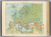
11-12. Europa fisica.
1 : 12000000 Touring club italiano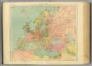
13-14. Europa politica.
1 : 12000000 Touring club italiano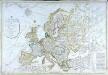
Carte générale de l'Europe
1 Karte : Kupferdruck ; 52 x 76 cm Hérisson; Basset; Basset chez Basset rue Jacques au coin de celle des Mathurins no. 670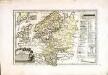
Das östliche und nördliche Europa
1 Karte : Kupferdruck ; 22 x 34 cm Reilly Franz J. J. von Reilly
Ubersicht von Europa; mit ethnograph.
1 : 19008000 Berghaus, Heinrich
[Übersicht von Europa mit ethnograph. Begränzung der einzelnen Staaten, und den Völker-Sitzen in der Mitte des 19ten Jahrhunderts]
Zweiter Band, enthaltend in vier Abtheilungen die Vertheilung der Organismen: 5. Pflanzen-Geographie, 6. Thier-Geographie, 7. Anthropographie, 8. Ethnographie Humboldt, Alexander von Verlag von Justus Perthes
Europa mit politischer Begränzung der einzelnen Staaten
Hand-Atlas über alle Theile der Erde nach dem neuesten Zustande und über das Weltgebäude Stieler, Adolf bei Justus Perthes
Europa mit politischer Begränzung der einzelnen Staaten
Hand-Atlas über alle Theile der Erde nach dem neuesten Zustande und über das Weltgebäude Stieler, Adolf bei Justus Perthes
Charte von Europa
1 Karte : Kupferdruck ; 43 x 54 cm Güssefeld bey den Homannis. Erben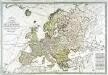
Carte générale de l'Europe
1 Karte auf 2 Blatt : Kupferdruck ; 51 x 75 cm Lotter; Lotter Lotter
Verbreitung Der Wichtigsten Kultur, - Baum - Und Strauchgewachse In Europa.
1 : 15000000 Berghaus, Heinrich
Versuch Einer Ubersicht Der Geographischen Verbreitung Der Gewitter.
Berghaus, Heinrich
Neue Charte über die Durchfarth gegen Nord-Ost zwischen Asien und America samt den nahegelegenen Inslen [sic] und Ländern
Asie východní Marianus, Joseph
Europa
Schul-Atlas über alle Theile der Erde nach dem neuesten Zustande, und über das Weltgebäude Stieler, Adolf bei Justus Perthes
Charte von Europa
1 Karte : Kupferdruck ; 38 x 47 cm Güssefeld zu finden bey C. Weigel u. Schneider