Maps of Edinburgh

Fifæ pars occidentalis
1 Karte : Kupferdruck ; 40 x 52 cm Blaeu Joan Blaeu
FIFÆ PARS | OCCIDENTALIS, | THE WEST PART OF FIFE.
[Amsterdam : Joan Blaeu]
Fife W.
1 : 75000 Martin, Alexander
Kinross - OS One-Inch map
1 : 63360 Topographic maps Ordnance Survey Ordnance Survey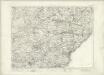
Kinross - OS One-Inch map
1 : 63360 Topographic maps Ordnance Survey Ordnance Survey
[Kinross] - OS One-Inch map
1 : 63360 Topographic maps Ordnance Survey Ordnance Survey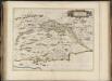
Fifae pars occidentalis, [vulgo], The West Part of Fife.
Blaeu, Joan, 1596-1673
Firth of Forth (68) - OS One-Inch map
1 : 63360 Topographic maps Ordnance Survey Ordnance Survey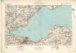
Firth of Forth (68) - OS One-Inch map
1 : 63360 Topographic maps Ordnance Survey Ordnance Survey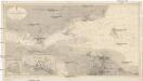
Nordsee
1 : 25000 Severní moře Reichs-Marine-Amt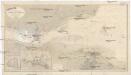
Nordsee
1 : 25000 Severní moře Reichs-Marine-Amt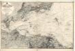
Firth of Forth: Fisherrow to Edgar
Great Britain. Hydrographic Office
A new description of the shyres Lothian and Linlitquo
1 : 171000
County of Kinross.
Bell, John, fl. 1792-1833
Environs of Edinburgh - Bartholomew's 'Survey Atlas of Scotland'
1 : 42240 Topographic maps John Bartholomew & Son, Ltd John Bartholomew & Son, Ltd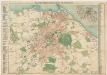
Bartholomew's pocket plan of Edinburgh
1 : 18500 John Bartholomew and Son J. Bartholomew & Son, Ltd.
Edinburgh environs.
1 : 85000 Society for the Diffusion of Useful Knowledge (Great Britain)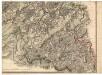
Edinburgh Shire.
Thomson, John, 1777- ca. 1840 Knox, James, fl. 1800-1856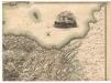
Edinburgh Shire.
Thomson, John, 1777- ca. 1840 Knox, James, fl. 1800-1856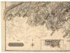
Edinburgh Shire.
Thomson, John, 1777- ca. 1840 Knox, James, fl. 1800-1856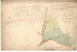
Plan of Baron Norton's Feu at Norton Place.
Ainslie, John, 1745-1828
Plan of Warriston policies and adjoining grounds in Edinburgh.
Johnston, William, 1802-1888 Johnston, Alexander Keith, 1804-1871
Plan of the Estates of Ravelston and Corstorphinhill.
Crawford, David, fl. 1802-1829
Johnston's plan of Edinburgh & Leith.
Lancefield, Alfred, fl. 1843-1855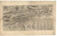
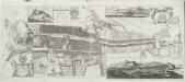
City and castle of Edinburgh.
Edgar, William, fl. 1717-1746
Plan of Edinburgh, Leith & suburbs, showing the division of the city into thirteen wards in terms of the Edinburgh Municipality Extension Act, 1856.
Johnston, William, 1802-1888 Johnston, Alexander Keith, 1804-1871
City of Edinburgh.
Ainslie, John, 1745-1828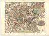
Plan of the City of Edinburgh, including all the latest and intended improvements.
Wood, John, ca. 1780-1847 Brown, Thomas, fl. 1785-1820
Kay's plan of Edinburgh.
Kay, James
Edenburck in Schottl.

Sketch of the City of Edinburgh and Leith.
Crawford, David, fl. 1802-1829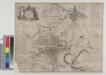
The Strangers Guide, being a Plan of Edinburgh & Leith exhibiting all the streets principal buildings & late improvements...
The Plan of Edinburgh, exactly done...
Gordon, James, 1615-1686 Wit, Frederik de.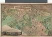
Plan of the Town of Leith and its environs.
Thomson, Charles, fl. 1820-1831
Johnston's plan of the City of Edinburgh.
Lancefield, Alfred, fl. 1843-1855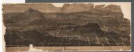
Edinburgh.
Sulman, J.
Old and New Town of Edinburgh and Leith with the proposed docks.
Ainslie, John, 1745-1828
This plan of the City of Edinburgh and its environs.
Kirkwood, Robert, fl. 1806-1828
Plan & section of the road from Granton Pier through the lands of His Grace The Duke of Buccleuch.
Stevenson, Robert & Son
Johnston's plan of Edinburgh & Leith.
Lancefield, Alfred, fl. 1843-1855
Plan of the City of Edinburgh, including all the latest and intended improvements.
Wood, John, ca. 1780-1847 Brown, Thomas, fl. 1785-1820
Plan of the lands of Newington and Bellville.
Leslie, John, ca. 1778-1830
A plan of the city and suburbs of Edinburgh.
Kincaid, Alexander, 1710-1777
Plan of the Regality of Canongate comprising the Liberties of Pleasance, North Leith, Coal-hill and Citidal thereof. Plan of North Leith within the Regality of Canongate.
Bell, William, fl. 1760-1813
Kirkwood's new plan of the City of Edinburgh.
Kirkwood, James, 1745/6-1827 & Sons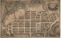
Plan & elevation of the New Town of Edinburgh.
Kirkwood, Robert, fl. 1806-1828
This plan of the City of Edinburgh and its environs.
Kirkwood, Robert, fl. 1806-1828
City of Edinburgh Housing and Town Planning, etc., Act 1909. Bellevue & McDonald Road Area.
Edinburgh Burgh Engineer
An Ancient Plan of the City of Edinburgh and its Environs... Intended as an accompaniment to Kirkwood's New Plan of Edinburgh.
Kirkwood, Robert, fl. 1806-1828
Plan of feued and unfeued grounds. Hope Parkend.
Gellatly, John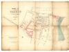
Feuing plan of the lands of Grange.
Raeburn, Robert
Bellevue town planning scheme. No. 3. Plan of Ground and Buildings as Existing.
Marwick, Thomas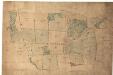
Sketch of Ravelston.
Anon.
Edimbourg.
Manesson-Mallet, Allain, 1630?-1706?
Plan of the estate of Ravelrig.
Johnston, William, 1802-1888 Johnston, Alexander Keith, 1804-1871
To the Noblemen and Gentlemen of the Highland and Agricultural Society of Scotland, this geometrical and geological landscape... from ... Leith to ... Edinburgh.
Moffat, William, fl. 1828-1837
The City of Edinburgh.
Stevenson, Robert & Son
To His Sacred Majesty George III... this Plan of the new streets and squares, intended for his ancient capital of North-Britain... is inscribed by... James Craig
Craig, James, d. 1795.
Plan of the lands of Braehead Mains.
Johnston, William, 1802-1888 Johnston, Alexander Keith, 1804-1871
Johnstons' plan of Edinburgh, Leith, Portobello and environs, constructed from the latest surveys with additions by the local surveyors of these towns.
Johnston, William, 1802-1888 Johnston, Alexander Keith, 1804-1871
Chronological map of Edinburgh showing expansion of the City from earliest days to the present.
Bartholomew, John G., 1860-1920


