Maps of Nottinghamshire

Maps of Nottinghamshire

$title$

An accurate map of Nottingham Shire

1 Karte : Kupferdruck ; 68 x 52 cm Bowen; Tinney; Bowles; Sayer; Bowles; Bowles printed for T. Bowles in St. Pauls Church Yard John Bowles and son in Cornhil John Tinney and Robert Sayer in Fleet street
$title$

Comitatvs Nottinghamiensis

1 Karte : Kupferdruck ; 37 x 48 cm Blaeu Joan Blaeu
$title$

$title$

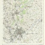
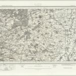
Nottingham - OS One-Inch Map

1 : 63360 Topographic maps Ordnance Survey Ordnance Survey
$title$

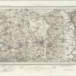
East Retford (Hills) - OS One-Inch Revised New Series

1 : 63360 Topographic maps Ordnance Survey Ordnance Survey
$title$

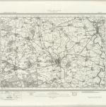
East Retford (Outline) - OS One-Inch Revised New Series

1 : 63360 Topographic maps Ordnance Survey Ordnance Survey
$title$

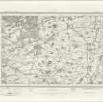
Ollerton (Outline) - OS One-Inch Revised New Series

1 : 63360 Topographic maps Ordnance Survey Ordnance Survey
$title$

Ollerton (Hills) - OS One-Inch Revised New Series

1 : 63360 Topographic maps Ordnance Survey Ordnance Survey
$title$

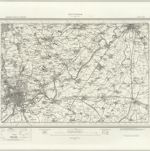
Nottingham (Outline) - OS One-Inch Revised New Series

1 : 63360 Topographic maps Ordnance Survey Ordnance Survey
$title$

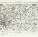
Nottingham (Hills) - OS One-Inch Revised New Series

1 : 63360 Topographic maps Ordnance Survey Ordnance Survey
$title$

The English Channel 1542-44

This is a chart of the English Channel possibly dating from 1542-4. It shows the south coast of England and the facing French shore, from Calais to Brittany. It is drawn in ink over a pale blue wash and is characterized by delicate renderings of vegetation and wind heads. One of the wind heads differs from the others in that it is a death head, blowing from the south. The presence of the death head on the French side of the channel may be a comment on the negative Anglo-French relationship at this time as hostilities resumed once more in 1542. The cartographer is not confirmed but the hand is French and similar to writing on another map (BL. Royal MS 20.E.IX) which is attributed to Jean Rotz, a Frenchman in the service of Henry VIII, suggesting that this too is his work. The chart is drawn to approximately 1:637500 and a scale bar measuring 16cm representing 25 lienes is included along the right hand margin. It shows the English coast from St Margaret’s to the Scilly Isles, although these have been added later as they are drawn over the top of the blue wash. The detail of the east part of the English coast line is relatively accurate but the west is less so. The French coast is shown from Calais to Ouissant, off Brittany. Special attention is paid to the nature of the coasts as cliffs and sandy beaches are indicated. The interior detail consists of trees and hills which seem to correspond to the real location of rages of hills. Lines have been inserted at Pourboul and Valongnes, close to Bayeux. Adjacent to Valonges an italic hand has inserted view point’. Rotz, Jean
$title$

Part of Nottinghamshire H. Stevens. 1820.''(002OSD000000004U00252000)

1 : 31680 .This plan covers an area of 82.625 square miles,in Nottinghamshire and Lincolnshire. The county boundary is indicated by a red pecked line following the course of the River Trent down the right of the sheet. Land use is indicated by colours instead of the conventional symbols: dark green for woodland, lighter green for meadows and light brown for arable land. Stevens, Henry
$title$

Melton Mowbray (Hills) - OS One-Inch Revised New Series

1 : 63360 Topographic maps Ordnance Survey Ordnance Survey
$title$

Melton Mowbray (Outline) - OS One-Inch Revised New Series

1 : 63360 Topographic maps Ordnance Survey Ordnance Survey
$title$

Newark-on-Trent

1 : 31680 This drawing covers part of Nottinghamshire, with the city of Newark-on-Trent, at top right, in the flat and fertile lowland of the Trent Valley. A canal connects the city to the Trent Navigation. The Fosse Way runs from bottom left to top right. This Roman road stretched from Exeter to Lincoln, via Bath, Cirencester, and Leicester. The pencil lines used to plot the survey are clearly visible on the map. Stevens, Henry
$title$

Part of Nottinghamshire H. Stevens. 1820.''(002OSD000000004U00251000)

1 : 31680 .This drawing covers part of Nottinghamshire, with the River Trent depicted down the right of the sheet. Land use is indicated by colours instead of the conventional symbols: dark green for woodland, lighter green for meadows and light brown for arable land. The date, given as 1820,in the title, refers to the,year of the survey, not the drawing. Stevens, Henry
$title$

Nottingham 12

1 : 31680 This drawing covers,the border territory,of Nottinghamshire and Leicestershire, the county boundary being indicated by a red dotted line at lower right. The city of Nottingham and the broad floodplain,that characterises this part of the Trent Valley,are depicted at the top of the sheet., The undulating countryside of the Nottinghamshire Wolds is represented by soft brushwork interlining ('hachuring') in the lower part of the sheet. Stevens, Henry
$title$

Melton Mowbray, Leicestershire

1 : 31680 This plan covers parts of Nottinghamshire, Leicestershire and Rutland, with the county borders indicated by a red dotted line. Down the left of the sheet is depicted the Fosse Way, the Roman road running from Exeter to Lincoln, via Bath, Cirencester, and Leicester. The Oakham Canal is shown following the course of the River Eye at middle right. Surveyed by Benjamin Bevan and opened in 1803, this entirely man-made waterway passed many Rutland villages on its circuitous route from Melton Mowbray to Oakham. Boyce
$title$

SK79 - OS 1:25,000 Provisional Series Map

1 : 25000 Topographic maps Ordnance Survey Ordnance Survey
$title$

SK78 - OS 1:25,000 Provisional Series Map

1 : 25000 Topographic maps Ordnance Survey Ordnance Survey
$title$

SK77 - OS 1:25,000 Provisional Series Map

1 : 25000 Topographic maps Ordnance Survey Ordnance Survey
$title$

SK69 - OS 1:25,000 Provisional Series Map

1 : 25000 Topographic maps Ordnance Survey Ordnance Survey
$title$

SK76 - OS 1:25,000 Provisional Series Map

1 : 25000 Topographic maps Ordnance Survey Ordnance Survey
$title$

SK68 - OS 1:25,000 Provisional Series Map

1 : 25000 Topographic maps Ordnance Survey Ordnance Survey
$title$

SK75 - OS 1:25,000 Provisional Series Map

1 : 25000 Topographic maps Ordnance Survey Ordnance Survey
$title$

SK67 - OS 1:25,000 Provisional Series Map

1 : 25000 Topographic maps Ordnance Survey Ordnance Survey
$title$

SK59 - OS 1:25,000 Provisional Series Map

1 : 25000 Topographic maps Ordnance Survey Ordnance Survey
$title$

SK74 - OS 1:25,000 Provisional Series Map

1 : 25000 Topographic maps Ordnance Survey Ordnance Survey
$title$

SK66 - OS 1:25,000 Provisional Series Map

1 : 25000 Topographic maps Ordnance Survey Ordnance Survey
$title$

SK58 - OS 1:25,000 Provisional Series Map

1 : 25000 Topographic maps Ordnance Survey Ordnance Survey
© MapTiler © OpenStreetMap contributors
How does it work?
These instructions will show you how to find historical maps online.
Getting started
Type the place name in the search box to find the exact location. You can further adjust the search by zooming in and out.
Zoom
Zoom in and out with the buttons or use your mouse or touchpad natively.
Exact Area tool
Click here and draw a rectangle over the map to precisely define the search area.
Set filters
Narrow your search with advanced settings, such as Years (from/to), Fulltext, Publisher, etc.
Results
See the results of your search on the right side. You can scroll down to find more maps of this location.
?

Download OldMapsOnline Mobile