Maps of Wales
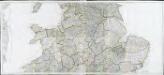
Partie meridionale de la Grande Bretagne, 1
6 Blätter : 47 x 107 cm T. Jeffereys
Road map of Great Britain
1 : 633600 Birmingham (Anglie) Ordnance Survey Office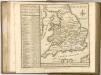

A new and accurate map of all the direct & principal cross roads in England and Wales
Anglie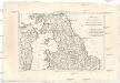
Royaume d'Angleterre
1 : 1950000 Anglie severní Bonne, Rigobert André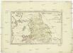
Postkarte von Nord England
Anglie severní Ponheimer, Kilian im von Reillyschen Landkarten und Kunstwerke Verschleiss Komptoir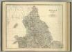
England and Wales (northern sheet).
1 : 887000 Johnston, Alexander Keith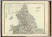
England and Wales (northern sheet).
1 : 887000 Johnston, Alexander Keith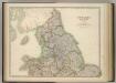
England and Wales (northern sheet).
1 : 887000 Johnston, W. & A.K.
Carte de la république de France, 7
1 Blatt : 36 x 59 cm s.n.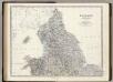
England, Wales N.
1 : 887000 Johnston, Alexander Keith, 1804-1871
Westmorlandia, Lancastria, Cestria, Caernarvan, Denbigh, Flint, Merionidh, Montogomery, Salopia Cum insulis Mania Et Anglesey. [Karte], in: Atlas, sive, Cosmographicae meditationes de fabrica mundi et fabricati figura, S. 113.
1 Karte aus Atlas Mercator, Gerhard
Westmorlandia, Lancastria, Cestria, Caernarvan, Denbigh, Flint, Merionidh, Montogomery, Salopia Cum insulis Mania Et Anglesey. [Karte], in: Gerardi Mercatoris Atlas, sive, Cosmographicae meditationes de fabrica mundi et fabricati figura, S. 115.
1 Karte aus Atlas Mercator, Gerhard Montanus, Petrus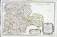
Anciens royaumes de Mercie, et East-Angles
1 Karte : Kupferdruck ; 35 x 56 cm Sanson; Fortin chez Fortin ing.r pour les globes rue de la Harpe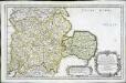
Anciens royaumes de Mercie, et East-Angles
1 Karte : Kupferdruck ; 34 x 56 cm Sanson chez l'auteur
Eboracvm, Lincolnia, Derbia, Staffordia, Notinghamia, Lecestria, Rvtlandia, et Norfolcia
1 Karte : Kupferdruck ; 34 x 40 cm Mercator; Hondius Henricus Hondius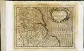
Eboracum, Lincolnia, Derbia, Staffordia, Notinghamia, Lecestria, Rutlandia, et Norfolcia
1 Karte : Kupferdruck ; 17 x 24 cm Mercator; Keere Cloppenburgh
Eboracvm, Lincolnia, Derbia, Staffordia, Notinghamia, Lecestria, Rvtlandia, et Norfolcia
1 Karte : Kupferdruck ; 34 x 40 cm Mercator; Hondius Jodocus Hondius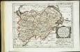
Des Königreichs England westlicher Theil, oder Hereford Shire, Worcester Sh, Warwick Shire
1 Karte : Kupferdruck ; 19 x 25 cm Reilly F. J. J. von Reilly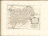


Watershed map England, Wales 3.
1 : 760320 Letts, Son & Co.
Eboracum, Lincolnia, Derbia, Staffordia, Notinghamia, Lecestria, Rutlandia, Et Norfolcia. [Karte], in: Atlas, sive, Cosmographicae meditationes de fabrica mundi et fabricati figura, S. 119.
1 Karte aus Atlas Mercator, Gerhard
Watershed map England, Wales 4.
1 : 760320 Letts, Son & Co.
Eboracum, Lincolnia, Derbia, Staffordia, Notinghamia, Lecestria, Rutlandia, Et Norfolcia. [Karte], in: Gerardi Mercatoris Atlas, sive, Cosmographicae meditationes de fabrica mundi et fabricati figura, S. 124.
1 Karte aus Atlas Mercator, Gerhard Montanus, Petrus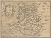
Cambriae Typus [Karte], in: Theatrum orbis terrarum, S. 86.
1 Karte aus Atlas Ortelius, Abraham Vrients, Jan Baptista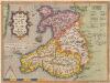
Cambriae Typus [...] [Karte], in: Theatrum orbis terrarum, S. 39.
1 Karte aus Atlas Ortelius, Abraham
Cambriae Typus [Karte], in: Gerardi Mercatoris Atlas, sive, Cosmographicae meditationes de fabrica mundi et fabricati figura, S. 118.
1 Karte aus Atlas Mercator, Gerhard Montanus, Petrus
Principatus Walliae Pars Borealis vulgo North Wales
1 : 390000 Amstelodami : apud Joannem Janssonium


