Maps of Dinaric Alps
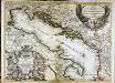
Le golfe de Venise
1 Karte : Kupferdruck ; 53 x 73 cm Sanson; Jaillot; Coronelli chez H. Jaillot
Le Golfe De Venise, Avec ses Principaux Caps. Promontoires, & Ports de Mer. [Karte], in: Atlas nouveau, contenant toutes les parties du monde [...], Bd. 2, S. 238.
1 Karte aus Atlas Sanson, Nicolas Jaillot, Alexis Hubert und Mortier, Pieter
[Das Adriatische Meer]
Hand-Atlas über alle Theile der Erde nach dem neuesten Zustande und über das Weltgebäude Stieler, Adolf bei Justus Perthes
Das Adriatische Meer
Stieler's Hand-Atlas Stieler, Adolf bei Justus Perthes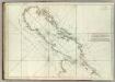
Carte De La Mer Mediterranee. VII.
Roux, Joseph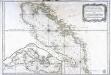
Carte hydrographique du golphe de Venise
1 Karte : Kupferdruck ; 58 x 85 cm Bellin s.n.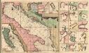
Pas-Caart-van de Weder zytsche Zee-kusten soo van Italia als Dalmatia en Griecken Inde Golff van Venetien
1 : 1400000 Mollova mapová sbírka Keulen, Gerard van Keulen, Gerard van
Adriatischer Dienst inclusive Corfu u. Prevesa
Jaderské moře-oblast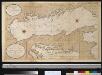
Nette afteekening van de Golf van Venetia vertoonende alle desselfs haavenen reede en baije in grood besteck
Italy Gerard van Keulen
Le golfe de Venise
1 Karte : Kupferdruck ; 51 x 58 cm Fer; Starckman chez l'auteur dans l'isle du Palais sur le quay de l'Orloge a la Sphere Royale
Carte de geographie des differents etats de la republique de Venise, l'abregé de son gouvernement politique et ecclesiastique, et les etats ou elle a porté la gloire de ses armes
1 : 4300000 Benátky-oblast (Itálie) Chatelain, Henri-Abraham Chatelain
Golfe de Venise
1 Karte : Kupferdruck ; 43 x 49 cm Aa Pieter van der Aa
Le Golfe de Venise
1 : 400000 Mollova mapová sbírka Sanson, Guillaume Jaillot, Alexis Hubert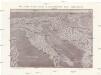
Plastická mapa Italie a přímořských zemí rakouských
Itálie Batěk, J. Emil Šolc
Italia Antiqva
1 : 8400000 Mollova mapová sbírka Clüver, Philipp Fuhrmann, Mathias
Karta o dubljinama Jadranskoga mora
Jaderské moře
Reiseskizze der 12. Termifahrt S.M.S. Najade
Jaderské moře Cori, Carl J. K. u. k. Kriegsmarine
Skelettkarte des Adriatischen-Meeres für Kursskizzen
Jaderské moře K. u. k. Kriegsmarine
Le Golfe de Venise :
1 : 180000 Mollova mapová sbírka Fer, Nicolas de Starckman, P. Danet, Guillaume
Charte von der Provintz Venedig und den oestereichischen Küstenlaendern Istrien und Dalmatien dann von dem Adriatischen Meere
1 : 1540000 Benátsko (Itálie) Liechtenstern, Joseph Marx von Hohlgartt, Ludwig Grafen von Kunst und Industrie Comptoirs
Partie Orientale De L'Italie qui comprend Les Royaumes De Naples Et De Sicile &c: [Karte] [südlicher Teil Siziliens] [Nebenkarte ], in: Atlas nouveau, contenant toutes les parties du monde [...], Bd. 2, S. 142.
1 Karte aus Atlas Sanson, Nicolas Jaillot, Alexis Hubert und Mortier, Pieter
Rajon dějstvīj russkago flota v vojnu s Francīej 1806-1807 gg. v Adrīatikě
Südeuropa Adria Seeschlacht
Militair Routen in Italien
1 : 1950000 Itálie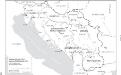
Jugoslawien nach dem Zweiten Weltkrieg (bis 1991) mit Republiken und Autonomen Provinzen
1 : 2500000 Jugoslawien Clewing, Konrad ; John, Holger W.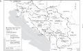
Staatenbildung im ehemaligen Jugoslawien, 1991 - 2008
1 : 2500000 Jugoslawien Auflösung, Staatenbildung Clewing, Konrad ; John, Holger W.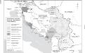
Besetzung und territoriale Aufteilung Jugoslawiens im Zweiten Weltkrieg
1 : 2500000 Jugoslawien Besetzung, Weltkrieg <1939-1945> Clewing, Konrad ; John, Holger W.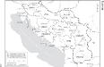
Die administrative Einteilung des Königreiches Jugoslawien nach Banschaften/banovine (ab 1929)
1 : 2500000 Jugoslawien Verwaltungsgliederung Clewing, Konrad ; John, Holger W.
Pannoniae, Et Illyrici Veteris Tabula. [Karte], in: Theatrum orbis terrarum, S. 383.
1 Karte aus Atlas Ortelius, Abraham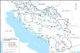
Das jugoslawische Eisenbahnnetz im Jahre 1918
1 : 2500000 Jugoslawien Eisenbahnnetz Kežić, Danijel ; John, Holger W.
Italy II.
1 : 1770000 Society for the Diffusion of Useful Knowledge (Great Britain)


