Maps of Turkey
Carte de la mer Mediterranée, 3
1 Blatt : 51 x 74 cm s.n.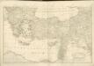

Carte reduite de la Mer Mediterranée, 3
1 Blatt : 59 x 51 cm ; s.n.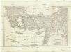
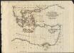
[Balkán a Malá Asie]
1 : 2850000 Balkánský poloostrov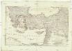
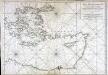
[Balkán a Malá Asie]
1 : 2850000 Balkánský poloostrov
Travels of St. Paul. Lower Egypt
1 : 8400000 Hughes, William
Colonia romana, Tabula geographica provinciarum et urbium.
1 : 5000000 L'Isle, Guillaume de, 1675-1726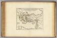
Colonia Romana, Tabula Geographica Provinciarum et Urbium.
1 : 5000000 L'Isle, Guillaume de, 1675-1726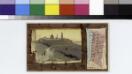
Palestine.
From [Series of advertising cards issued by Arbuckle Bros. Coffee Company, each consisting of a map of a country of the world with related illustrations.]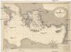
Mittelmeer
1 : 2500000 Středozemní moře (východní oblast) Reichs-Marine-Amt
Schul-Atlas für die alte Erdbeschreibung : zur allgemeinen Schul-encyclopädie gehörig
J. H. Campe Zusammensetzung und Zeichnung von [...] Dufour, unter Leitung von Heusinger ; gestochen von Frentzel. Braunschweig : Schulbuchhandlung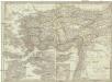
Asia minor, Syria, Cyprus, Creta & insulae maris Aegaei
1 : 3800000 Egejské moře Spruner, Karl von Poppey Justus Perthes
Klein-Asien & Syrien Nebst Den Westlichen Theilen Von Armenien, Kurdistan & Mesopotamien.
1 : 3700000 Petermann, A.
[Klein-Asien & Syrien, Nebst den Westlichen Theilen von Armenien, Kurdistan & Mesopotamien]
Handatlas über alle Theile der Erde und über das Weltgebäude Stieler, Adolf Justus Perthes
Letecká navigační mapa

Die asiatische Türkei...

Klein-Asien & Syrien nebst den westlichen Theilen von Armenien, Kurdistan & Mesopotamien
Hand-Atlas über alle Theile der Erde und über das Weltgebäude Stieler, Adolf Justus Perthes
Natoliae, Quae Olim Asia Minor, Nova Descriptio. [Karte], in: Theatrum orbis terrarum, S. 411.
1 Karte aus Atlas Ortelius, Abraham Vrients, Jan Baptista
Natoliae, Quae Olim Asia Minor, Nova Descriptio. [Karte], in: Theatrum orbis terrarum, S. 119.
1 Karte aus Atlas Ortelius, Abraham
Natoliae, Quae Olim Asia Minor, Nova Descriptio. [Karte], in: Theatrum orbis terrarum, S. 310.
1 Karte aus Atlas Ortelius, Abraham
88-89. Turchia, Siria, Palestina.
1 : 3000000 Touring club italiano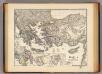
Graecia tempore migrationis doricae.
1 : 3800000 Menke, Th.
Egypte, Syrie Phoenicie et Asie Mineure.
1 : 5400000 Monin, C.V.
Asia Minor et Syria
Schul-Atlas der alten Welt bei Justus Perthes
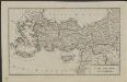
Turkey in Asia.
1 : 5300000 Hughes, William
Kleinasien und Syrien
Neuer Handatlas über alle Theile der Erde Kiepert, Heinrich Verlag von Dietrich Reimer
Natoliae Sive Asia Minor [Karte], in: Gerardi Mercatoris Atlas, sive, Cosmographicae meditationes de fabrica mundi et fabricati figura, S. 520.
1 Karte aus Atlas Mercator, Gerhard Montanus, Petrus
Turkey in Asia.
1 : 4100000 Hall, S. (Sidney)