Maps of United Kingdom

Paskaarte om achter Yrlant om te zeylen, van Hitlant tot aen Heÿssant
1 Karte : Kupferdruck ; 43 x 54 cm Doncker by Hendrick Doncker in de Nieuwbrughsteech in 't Stuurmans gereetschap
Pas-Caart vant Canaal 't Amsterdam. [Karte], in: De Nieuwe Groote Vermeerderde Zee-Atlas ofte Water-Werelt, S. 41.
1 Karte aus Atlas Doncker, Hendrick
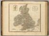
British Islands.
1 : 2300000 Lizars, Daniel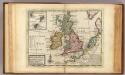
A general map of Great Britain and Ireland.
1 : 7500000 Moll, Herman, d. 1732
Grossbritanien und Irrland
Allgemeiner Atlas [Walch, Johannes] im Verlag bei Johannes Walch
Die Brittischen Inseln
Schul-Atlas über alle Theile der Erde nach dem neuesten Zustande, und über das Weltgebäude Stieler, Adolf Justus Perthes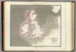
Tidal chart British Seas.
1 : 4900000 Russell, J. Scott (John Scott), 1808-1882
Neueste Karte von Grossbritannien und Jreland
Grosser Hand-Atlas über alle Theile der Erde in 170 Karten Meyer, J. Verlag des Bibliographischen Instituts
Tidal Chart of the British Seas
The physical atlas Johnston, Alexander Keith William Blackwood & Sons
Great Britain and Ireland.
1 : 4100000 Gray, Ormando Willis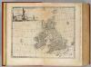
Great Britain & Ireland.
1 : 4250000 Bowen, Emanuel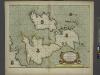
A new and correct chart of the sea coast of ENGLAND, SCOTLAND and IRELAND
from The sea-atlas : containing an hydrographical description of most of the sea-coasts of the known parts of the world.
45-46. Gran Bretagna.
1 : 3000000 Touring club italiano
Different Routes of Prince Edward in Great Britain
Maps are usually made by conquerors. This is an exception: it was made by the side that lost. The map was drawn by James Grant, a French officer of Scottish descent who fought alongside Bonnie Prince Charlie throughout his campaigns, including the Battle of Culloden, and accompanied him on his flight to France. The map bears the royal arms of the Stuart kings and records in detail the battles and sieges of the Jacobite campaign. Allegorical figures, such as Justice, dignify the conflict. The Prince’s escape route is watched over from the clouds by the gods of classical mythology: Venus, Zephyr, Apollo, Mercury and Neptune. In a rebuttal of the English propaganda that followed the defeat of the Jacobite Uprising, the map is pointedly Inscrib’d to all the Honest. Grant, James A.
Grossbritannien, Ireland.
1 : 3800000 Flemming, Carl
Iles Britanniques.
1 : 2500000 Lapie, M. (Pierre), 1779-1850
Pas-caart van 't Canaal
1 Karte : Kupferdruck ; 44 x 54 cm Doncker bij Hendrick Doncker boekverkooper en graadbooghmaecker inde Nieuwbrughsteegh in 't Stuurmans gereedtschap
Die Britischen Jnseln England, Schotland, Jreland
Stieler's Hand-Atlas Stieler, Adolf bei Justus Perthes
Les Isles Britanniques : ou sont le royaumes d'Angleterre tiré de Speed, celuy d'Ecosse tiré de Th. Pont et celuy d'Irlande tiré de Petit / le tout rectifié par diverses observations par G. de l'Isle
1 : 2650000 titelvariant: Magnae Britanniae tabula; Annotatie: Titel boven de kaart: Magnae Britanniae tabula : comprehendens Angliae, Scotiae, ac Hiberniae regna, ad usum serenissimi Burgundiae Ducis; Oorspr. verschenen in: Atlas nouveau ... / par Guillaume de l'Isle. - Amsterdam : Jean Covens & Corneille Mortier, 1730 Isle, Guillaume de l' Amsteldam : I. Covens & C. Mortier
Map of the British Isles.
1 : 3500000 Warner & Beers
British Isles.
1 : 4100000 Cornell, S. S. (Sarah S.)
Iles Britanniques, chemins de fer, canaux.
1 : 2700000 Garnier, F. A., 1803-1863
Iles Britanniques.
1 : 2900000 Garnier, F. A., 1803-1863
British Isles.
1 : 9300000 Fenner, Rest.
Gt. Britain, Ireland.
1 : 1800000 Robert Laurie & James Whittle
A compleat map of the British Isles.
1 : 2200000 Kitchin, Thomas
Anglia, Scotia et Hibernia. [Karte], in: Gerardi Mercatoris Atlas, sive, Cosmographicae meditationes de fabrica mundi et fabricati figura, S. 82.
1 Karte aus Atlas Mercator, Gerhard Montanus, Petrus
Grossbritannien, Irland.
1 : 2500000 Andree, Richard
Die Brittischen Inseln
Schul-Atlas über alle Theile der Erde nach dem neuesten Zustande, und über das Weltgebäude Stieler, Adolf bei Justus Perthes