Maps of Texas
A new discription of Carolina by the order of the Lords Proprietors.
1 : 1648000 Covers Atlantic coast from St. Augustine to James Town. Relief shown pictorially. Oriented with north to right. Includes inset [ca. 1:190,080]: "Charles Town, Ashley and Cooper rivers" Ogilby, John, 1600-1676.;Moxon, J. (James) [John Ogilby]
Texas. Kentucky. Tennessee.
1 : 3743000 Gray, Ormando Willis
Colton's U.S. section.
1 : 3168000 United States. War Department
Charte pour servir au voyage des cap.es Lewis et Clarke a l'ocean Pacifique 1804
Severní Amerika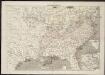
Frank Leslie's war maps
Leslie, Frank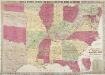
Phelps & Watson's Historical and Military Map of the Border and Southern States.
Phelps & Watson's Historical and Military Map of the Border and Southern States. This map, produced in New York in 1863 shows all the Confederate states, including a sizable amount of Texas, as well as the Border States of the Union. It is noteworthy that by this point in the war, Virginia has split into to, with the western half seceding from the rest of the state. West Virginia was admitted to the Union in 1863 and the map clearly shows the separation. The map also contains a list of the major battles from 1861 and 1862 in the bottom right hand corner.
Map of the Indian Territory, Northern Texas and New Mexico.
from Supplement to the New York observer.
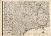
Southern Section of the United States including Florida.
1 : 3928320 Melish, John
Southern Section of the United States including Florida.
1 : 3928320 Melish, John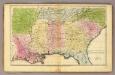
Southern States.
1 : 3600000 Huntington, Francis Junius, 1802-1878
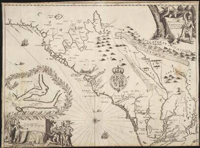
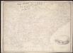
A New Mapp of Carolina
1 : 1040480 Map depicts the coasts of Virginia, North Carolina, and South Carolina, from Cape Charles south to Port Royall. Depth shown by soundings and bathymetric shading. Towns, barrier islands, and rivers are shown. Inset map depicts "A Large Draught of Ashly and Coopers River," including Charleston, S.C., with sailing instructions and soundings. Map is printed with North oriented to the right. Thornton, John, fl. 1652-1701.;Fisher, William, fl. 1669-1691.
Southern States. (with) South Part of Florida.
1 : 3450000 Smiley, Thomas T.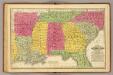
Southern States.
1 : 3700000 Mitchell, Samuel Augustus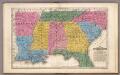
Map of the Southern States.
1 : 3700000 Mitchell, Samuel Augustus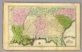
Southern States.
1 : 3500000 Olney, J. (Jesse), 1798-1872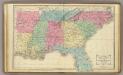
Southern U.S.
1 : 3500000 Cornell, S. S. (Sarah S.)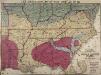
Lloyd's New Military Map of the Border and Southern States
Lloyd's New Military Map of the Border and Southern States. Lloyd’s New Military Map of the Border and Southern States from 1865 provides a clear example of the territory held by the Confederate and Union Armies at the end of the Civil War. The red parts indicated Confederate territory, now very much reduced compared to the other maps, the yellow parts show areas gained by the Union Army since early January 1862 and the blue part shows the route taken by General Sherman’s troops during their march through the South. The green indicates the Union. This map highlights how divided the Border States were with portions of Missouri and Kentucky coloured to indicate Union occupation. Although these both remained in the Union, internal civil struggles threatened to divide the states and Lincoln campaigned hard to ensure these states remained together. By comparison, Virginia witnesses an internal secession in 1863 and West Virginia can clearly be seen here on this map as part of the Union. This map is one of the best maps in the collection that detail how far the Union Army went into occupying the Confederate states and reuniting the country.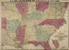
Lloyd's New Military Map of the Border and Southern States
Lloyd's New Military Map of the Border and Southern States. This map was published by H.H. Lloyd & Co. in 1862. The map shows mid America from the lower border of the Union to the eastern edge of Texas, thus showing all eleven Confederate states. Railway lines and fortifications are also labelled on the map.
The Field of Battle.
The Field of Battle and Prominent US Generals. The Field of Battle and Prominent Union Generals is one of the most picturesque maps in the collection, detailing the main theatres of conflict in the Confederacy, with each state broken up by counties, and surrounded by virtually all of the main Union Army generals that would have been well known to viewers in 1864 when this map was published in New York by Ensign & Bridgman. The generals are mostly all arranged close to the areas where they were conducting operations at the time of the map’s production, for example Generals Grant and Sherman are close to Georgia and South Carolina. Union Navy generals are also pictured, such as General David Farragut who can be seen close to the Georgia coastline. Ensign & Bridgman
Lloyd's new military map of the border & southern states

[Die Vereinigten Staaten von Amerika in 6 Blättern, Blatt 5]
Adolf Stieler's Handatlas über alle Theile der Erde und über das Weltgebäude Stieler, Adolf Justus Perthes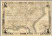
Map Of The Southern States
1 : 3612000 Harper's Weekly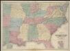
Map of the seat of war
War chart of the Southern States showing the towns, rivers, rail-roads and common roads
B.B. Russell & Co.
Perrine's new topographical war map of the southern states, taken from the latest government surveys and official reports
1 : 2000000 Perrine, Charles O. Perrine, Charles O.
Vereinigte Staaten Von Nord-Amerika In 6 Blattern, Bl. 5.
1 : 3700000 Petermann, A.
Shell Sectional Map No. 10 - Southwestern States.
1 : 3104640 Shell Oil Company
[Die Vereinigten Staaten von Nord-Amerika, Blatt 5]
Handatlas über alle Theile der Erde und über das Weltgebäude Stieler, Adolf Justus Perthes
War Chart of the Southern States.
War Chart of the Southern States. Published in 1862 by B.B. Russell in Boston, War Chart of the Southern States details the cities, towns, rivers, railroads and marked roads in the Confederacy (with the exception of Texas). The portrait at the bottom right of the map is of the Battle of Hampton Roads, which took place over two days in March 1862 off the Virginian coastline. The naval battle was famous for the fight between the USS Monitor, seen in the foreground of the image, and the CSS Merrimac (sometimes referred to as the CSS Virginia due to the fact that it was built from composite parts of Confederate ships). As can be seen in the image, these ships were ‘ironclads’, built with iron and steel armoured plates. Originally a British naval design, the Civil War witnessed the first clash of these ships at the Battle of Hampton Roads, resulting in worldwide attention on this aspect of naval warfare in America. Arguably the battle between the Monitor and Merrimac was the most famous naval event of the conflict and there are numerous contemporary cultural references to the engagement in items produced during the war. The battle itself was inconclusive, although the Union suffered more casualties than their Confederate counterparts. B.B. Russell