Maps of Hochtaunuskreis
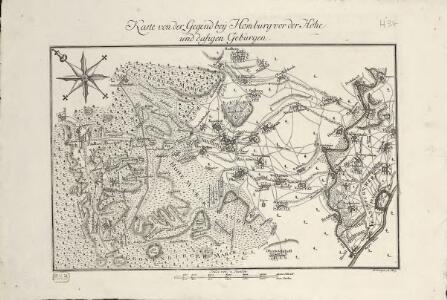
Karte von der Gegend bey Homburg vor der Höhe und dasigen Gebürgen
1 : 90000 Coentgen, Heinrich Hugo
Die Umgebung von Homburg = The environs of Homburg
1 : 75000 gez[eichnet] von Fritz Schick Bad Homburg : Louis Schick
Franckfurt mit der Gegend auf 2 Stund.
1 : 150000 Mollova mapová sbírka Bodenehr, Gabriel Bodenehr, Gabriel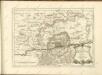
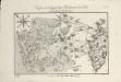
Plan de la Bataille de Bergen gagneé par Mr. Le Duc de Broglio Suv Le Prince Ferdinand Le 13. Avril 1759
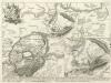
Battaille de Bergen près de Francofort gagneé par S. E. le duc de Brogliè sur S. A. le Pr. Ferdinand le 13 Avril 1759
1 : 60000 Mollova mapová sbírka Back, Jakob Conrad
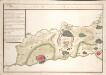
Abbildung der Keys[e]rl. Freyen Reichs-, Wahl- und Handelstatt Franckfurt am Mayn mit ihrem Gebiet und Gräntzen
1 : 65000 Homann, Johann Baptist
Meßtischblatt 3371 (35) : Frankfurt a.M. West (Steinbach), 1934
1 : 250000 Frankfurt a.M. West (Steinbach). - Hrsg. 1906, bericht. 1931, einz. Nachtr. 1934. - 1:25000. - [Berlin]: Reichsamt für Landesaufnahme, 1934. - 1 Kt.
Meßtischblatt 3371 : Höchst, 1906
1 : 250000 Höchst. - Aufn. 1904. - 1:25000. - [Berlin]: Kgl. Preuss. Landesaufnahme, 1906. - 1 Kt.
Meßtischblatt 43 : Rödelheim, 1876
1 : 250000 Rödelheim. - Aufn. 1867. - 1:25000. - [Berlin]: Kgl. Min. f. Handel, 1876. - 1 Kt.
Meßtischblatt 3326 : Homburg v. d. Höhe, 1907
1 : 250000 Homburg v. d. Höhe. - Aufn. 1904/05. - 1:25000. - [Berlin]: Kgl. Preuss. Landesaufnahme, 1907. - 1 Kt.
Meßtischblatt 37 : Homburg, 1876
1 : 250000 Homburg. - Aufn. 1867. - 1:25000. - [Berlin]: Kgl. Min. f. Handel, 1876. - 1 Kt.
Plan von Frankfurt am Main

Meßtischblatt 3370 : Königstein am Taunus, 1876
1 : 250000 Königstein am Taunus. - Aufn. 1868. - 1:25000. - [Berlin]: Kgl. Min. f. Handel, 1876. - 1 Kt.
Meßtischblatt 36 : Feldberg, 1876
1 : 250000 Feldberg. - Aufn. 1867. - 1:25000. - [Berlin]: Kgl. Min. f. Handel, 1876. - 1 Kt.
Meßtischblatt 3372 (36) : Frankfurt a. M. Ost (Offenbach), 1935
1 : 250000 Frankfurt a. M. Ost (Offenbach). - Hrsg. 1906, bericht. 1928, einz. Nachtr. 1935. - 1:25000. - [Berlin]: Reichsamt für Landesaufnahme, 1935. - 1 Kt.
Meßtischblatt 3327/3372 : Frankfurt am Main, 1906
1 : 250000 Frankfurt am Main. - Aufn. 1904, hrsg. 1906. - 1:25000. - [Berlin]: Kgl. Preuss. Landesaufnahme, 1906. - 1 Kt.
Meßtischblatt 3372 : Frankfurt a. M., 1876
1 : 250000 Frankfurt a. M. - Aufn. 1867. - 1:25000. - [Berlin]: Kgl. Min. f. Handel, 1876. - 1 Kt.
Battaille de Bergen près de Francfort gagneé par S. E. le Duc de Brogliè sur S. A. le Pr. Ferdinand le 13. Avril 1759
Back, Jakob Conrad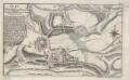
Plan der Bataille bey Bergen ohnweit Frankfurt am Mayn, zwischen den Französischen u. Alliirten Armeen. d. 13. Ap. A. 1759
1 : 20000 Raspe, Gabriel Nikolaus in der Raspischen Handlung
Bataille de Bergen prés Francfort
1 : 60000 Mollova mapová sbírka Trattner, Johann Thomas Trattner, Johann Thomas von
Meßtischblatt 3276 : Usingen, 1877
1 : 250000 Usingen. - Aufn. 1868. - 1:25000. - [Berlin]: Kgl. Min. f. Handel, 1877. - 1 Kt.
Meßtischblatt 3275 : Grävenwiesbach, 1935
1 : 250000 Grävenwiesbach. - Hrsg. 1907, bericht. 1935. - 1:25000. - [Berlin]: Reichsamt für Landesaufnahme, 1935. - 1 Kt.
Meßtischblatt 3275 : Grävenwiesbach, 1907
1 : 250000 Grävenwiesbach. - Aufn. 1905. - 1:25000. - [Berlin]: Kgl. Preuss. Landesaufnahme, 1907. - 1 Kt.
Meßtischblatt 29 : Gemünden, 1877
1 : 250000 Gemünden. - Aufn. 1868. - 1:25000. - [Berlin]: Kgl. Min. f. Handel, 1877. - 1 Kt.
Pharus-Plan Frankfurt a/M

Pharus-plan Frankfurt A/M
1 : 10200 Pharus-Verlag Pharus-Verlag
Bataille De Bergen Gagnée par l'Armée du Mem. Commandée par M. le Duc de Broglie, Sur celle des Allies Commandée par M. le Pr. Ferdinand de Brounswick le 13. Avril. 1759
1 : 13000 Coentgen, Heinrich Hugo; Brönner, Heinrich Ludwig chez Henrij Louis Brönner sur le Pfarreisen