Maps of Normandy
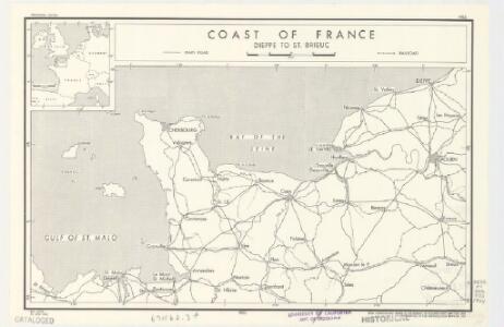
Coast of France : Dieppe to St. Brieuc
1 : 885000 Provisional ed. Inset: [Location map]. Shows main roads and railroads. Dated: 12 June 1944. United States. Office of Strategic Services. Research and Analysis Branch [Washington, D.C.] : R & A, OSS
Le Duché et gouvernement de Normandie
1 Karte : Kupferdruck ; 55 x 87 cm Sanson; Jaillot chez H. Iaillot au deux Globes
Le Duché et Gouvernement De Normandie divisée en Haute et Basse Normandie [...] [Karte], in: Atlas nouveau, contenant toutes les parties du monde [...], Bd. 1, S. 117.
1 Karte aus Atlas Sanson, Nicolas Jaillot, Alexis Hubert und Mortier, Pieter
Le Duché et gouvernement de Normandie
1 Karte : Kupferdruck ; 47 x 59 cm Jaillot A.-H. Jaillot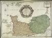
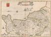
Le gouvernement general de Normandie
1 Karte : Kupferdruck ; 45 x 63 cm Desnos chez Desnos géographe ingénieur pour les globes spheres et instruments de mathématique rue St. Jacques au globe
Le Duché et gouvernement de Normandie
1 Karte : Kupferdruck ; 47 x 59 cm Jaillot chez J. Cóvens et C. Mortier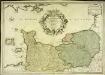
Le gouvernement general de Normandie
1 Karte : Kupferdruck ; 45 x 65 cm Fer; Danet; Starckman chez Danet gendre de l'auteur sur le pont Notre Dame a la Sphere royale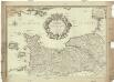
Le gouvernement general de Normandie, divisé en Haute et Basse
1 : 600000 Normandie (Francie) Fer, Nicolas de Danet, Guillaume Danet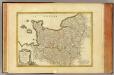
Normandie, Maine, Perche.
1 : 930000 Bonne, Rigobert, 1727-1794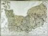
Gouvernement de Normandie
1 Karte auf 4 Blättern : Kupferdruck ; 60 x 82 cm Mentelle; Tardieu; Macquet Mentelle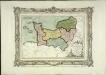
Carte des départemens de la Manche, du Calvados, de l'Orne, de l'Eure et de la Seine inférieure
1 Karte : Kupferdruck ; 22 x 32 cm, Bildgrösse 32 x 42 cm Brion de la Tour; Desnos chez le S. Desnos rue St. Jacques au globe
N.W. Normandy : fisheries
1 : 880000 Provisional ed. "Map no. 2324." "19 July 1943." Includes location map. United States. Office of Strategic Services. Research and Analysis Branch [Washington, D.C.] : R & A, OSS

Normandia Ducatus. [Karte], in: Gerardi Mercatoris et I. Hondii Newer Atlas, oder, Grosses Weltbuch, Bd. 2, S. 65.
1 Karte aus Atlas Mercator, Gerhard und Hondius, Jodocus Jansson, Jan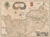
Normandia Ducatus. [Karte], in: Novus atlas absolutissimus, Bd. 4, S. 109.
1 Karte aus Atlas Janssonius Offizin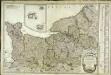
Carte du gouvernement de Normandie
1 Karte : Kupferdruck ; 47 x 64 cm Robert de Vaugondy; Fortin chés Fortin mécanicien du roy rue de la Harpe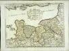
Duché et gouvernement de Normandie
1 Karte : Kupferdruck ; 37 x 50 cm Sanson; Cordier s.n.
Normandia Ducatus. [Karte], in: Theatrum orbis terrarum, sive, Atlas novus, Bd. 2, S. 74.
1 Karte aus Atlas Blaeu, Joan Blaeu, Willem Janszoon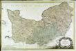
Carte de la Normandie
1 Karte auf 2 Blättern : Kupferdruck ; 62 x 96 cm Legendre; Lattré chez Lattré graveur ordinaire du roi de M. le Duc d'Orleans et de la ville rue St. Jacques a la ville de Bordeaux
Duché et gouvernement general de Normandie, divise en haut et bas en divers pays et balliages avec le gouvernement general de Havre de Grace
1 : 450000 par F. de Witt A Amsterdam : [F. de Wit]
Normannia ducatus, tum superior ad ortum, tum inferior ad occasum, præfectura generalis
1 Karte : Kupferdruck ; 46 x 58 cm Valck; Valck Gerard und Leonardus Valck
Normandia Ducatus. [Karte], in: Le théâtre du monde, ou, Nouvel atlas contenant les chartes et descriptions de tous les païs de la terre, Bd. 2, S. 120.
1 Karte aus Atlas Blaeu, Willem Janszoon und Blaeu, Joan Blaeu, Willem Janszoon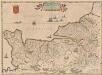
Normandia Ducatus. [Karte], in: Novus Atlas, das ist, Weltbeschreibung, Bd. 2, S. 121.
1 Karte aus Atlas Blaeu, Joan Blaeu, Willem Janszoon
Li governi di Normandia del Maine, e Perche
1 Karte : Kupferdruck ; 29 x 39 cm Zatta; Zuliani presso Antonio Zatta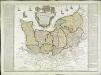
Carte de la province de Normandie qui comprend les gouvernements militaires de Normandie et du Havre de Grace
1 Karte : Kupferdruck ; 45 x 50 cm Nolin; Basset; Basset chez Basset rue St. Jacques
De Fransche Kanaalkust : (Cherbourg-Le Tréport)
1 : 1000000 Den Haag : Kompas
NORMANDIA | DVCATVS.
Excudit Guiljelmus Blaeu.
Duche et gouvernement general de Normandie
1 Karte : Kupferdruck ; 48 x 59 cm Wit se vend chez J. Cóvens et C. Mortier