Maps of Asia

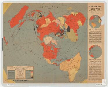
One world, one war; a map showing the line-up and the strategic stakes in this the first global war
"North polar azimuthal equidistant projection." "A Fortune map." "Supplement to Fortune, March, 1942." Includes text and maps of "The Atlantic bridge" and "The Pacific vastness." Harrison, Richard Edes and Time, inc [New York] : Time
Nord-America und West-Indien
Schul-Atlas über alle Theile der Erde nach dem neuesten Zustande, und über das Weltgebäude Stieler, Adolf Justus Perthes
Nord-America
Hand-Atlas über alle Theile der Erde nach dem neuesten Zustande und über das Weltgebäude Stieler, Adolf bei Justus Perthes
[Nord-Amerika]
Hypsometrischer Atlas Ziegler, Jakob Melchior Topogr. Anstalt v. J. Wurster u. Comp.
Nord-Amerika
[Allgemeiner Atlas über alle Theile der Erde in 29 Blättern] Ziegler, Jakob Melchior Top. Anstalt v. J. Wurster u. Comp.
Nord Amerika
Geographischer Atlas über alle Theile der Erde Ziegler, Jakob Melchior Verlag von Dietrich Reimer
Charte des Stillen Weltmeers im Nördlichen Aequator und der Küsten die es auf beiden Seiten einschraenken : nach den neuesten, von den Spaniern, Russen und Engellaendern bis 1780 gemachten Entdeckungen
1 : 37000000 [erl. von:] T. A. Mann Augsbourg : Tobie Conrad Lotter
Nord-Afrika
Adolf Stieler's Handatlas über alle Theile der Erde und über das Weltgebäude Stieler, Adolf Justus Perthes
North America
A new general atlas of modern geography, consisting of a complete collection of maps of the four quarters of the globe Wyld, James James Wyld
Nord-Amerika
Geographischer Atlas über alle Theile der Erde Ziegler, Jakob Melchior Verlag von Joh. Wurster um Comp.
Nord-America
Neuer Handatlas über alle Theile der Erde Kiepert, Heinrich Verlag von Dietrich Reimer
Nord-America
Stieler's Hand-Atlas Stieler, Adolf bei Justus Perthes
Nord-America
Handatlas über alle Theile der Erde und über das Weltgebäude Stieler, Adolf Justus Perthes
Ice Chart, Northern Hemisphere, August.
U.S. Navy
Ice Chart, Northern Hemisphere, May.
U.S. Navy
[Nord-Amerika]
Atlas der Geologie Zittel, K.v. ; Berghaus, Hermann Justus Perthes
Tartaria [Karte], in: Gerardi Mercatoris Atlas, sive, Cosmographicae meditationes de fabrica mundi et fabricati figura, S. 529.
1 Karte aus Atlas Mercator, Gerhard Montanus, Petrus
Nord-America
E. von Sydow's Schul-Atlas in sechs und dreissig Karten Sydow, Emil von bei Justus Perthes
Northern Hemisphere.
1 : 80000000 Greenleaf, Jeremiah
Northern Hemisphere.
1 : 80000000 Greenleaf, Jeremiah
VII. Charte für die allgemeine Geschichte von Papst Gregor VII. bis auf Rudolph von Habsburg : d.i. von 1073 bis 1273 nach Christus
Entworfen von F.W. Benicken gez. von C.F. Weiland ; in Stein gravirt v. A. Falger Weimar : im Verlage des L. Industrie-Comptoirs
Nord-America und West-Indien
Schul-Atlas über alle Theile der Erde nach dem neuesten Zustande, und über das Weltgebäude Stieler, Adolf bei Justus Perthes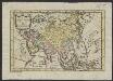
Asia, volgens de nieuwste waarneminge
1 : 100000000 H. Klockhoff del. et sc. Te Amsterdam : bij Arend Fokke, sim. z.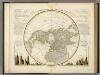
Die Isothermkurven Der Nordlichen Halbkugel.
1 : 65000000 Berghaus, Heinrich
Northern Hemisphere.
1 : 85000000 Burr, David H., 1803-1875
N. Hemisphere.
1 : 41000000 Thomson, John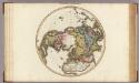
Northern Hemisphere.
1 : 42000000 Pinkerton, John, 1758-1826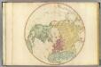
N. Hemisphere.
1 : 35000000 Faden, William, 1750?-1836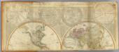
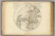
World (north)
1 : 43000000 Robert Laurie & James Whittle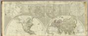
A general map of the world or terraqueous globe.
1 : 41000000 Dunn, Samuel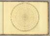
N. Hemisphere (blank)
1 : 35000000 Jefferys, Thomas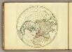
N. Hemisphere.
1 : 35000000 Jefferys, Thomas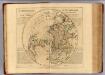
L'Hemisphere Septentrional.
1 : 37000000 L'Isle, Guillaume de, 1675-1726