Maps of San Pedro de Atacama

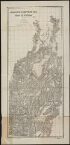
Demarcacion de limites con Chile. Puna de Atacama.
1 : 500000 Argentine. Oficina de Límites Internacionales [Buenos Aires ?] :
West Coast of South America.
Fullarton, A. & Co.
Carte des Provinces de Salta et de Jujuy et d'une partie de la Bolivie
1 : 2000000 Description géographique et statistique de la Confédération Argentine Martin de Moussy, Victor Librairie de Firmin Didot frères, fils et Cie
Carte des Provinces de Catamarca de Rucuman et des régions voisines
1 : 2000000 Description géographique et statistique de la Confédération Argentine Martin de Moussy, Victor Librairie de Firmin Didot frères, fils et Cie
Carte, provinces de Salta et Jujuy, partie de la Bolivie.
1 : 1850000 Martin de Moussy, V. (Victor), 1810-1869
Catamarca et Tucuman.
1 : 1850000 Martin de Moussy, V. (Victor), 1810-1869
Carte, Province de Santiago del Estero, Grand Chaco.
1 : 1850000 Martin de Moussy, V. (Victor), 1810-1869
Partie du Chili. Amer. Merid. 29.
1 : 1641836 Vandermaelen, Philippe, 1795-1869
Provincia de Catamarca.
1 : 1800000 Paz Soldan, Mariano Felipe, 1821-1886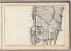
(Mapa de la Republica de Chile 2)
1 : 11000000 Pissis, Aime, 1812-1889
Partie du Perou. Amer. Merid. 25.
1 : 1641836 Vandermaelen, Philippe, 1795-1869
Carta de la rejion salitrera comprendida entre los paralelos 19° y 27°30' lat. sur
1 : 500000 (Chili) Delegacion fiscal de salitreras Antofagasta : Delegacion fiscal de salitreras
Partie, la Plata. Amer. Merid. 30.
1 : 1641836 Vandermaelen, Philippe, 1795-1869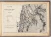
Mapa de la Republica de Chile (1)
1 : 11000000 Pissis, Aime, 1812-1889
Richard Mayer's commercial map of Northern Chili, Bolivia, & southern Peru
1 : 1000000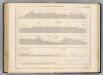
Coupe de la route de Buenos-Ayres a Lima.
1 : 1949000 Martin de Moussy, V. (Victor), 1810-1869
Ober-Paraguarien nebst denen Ländern Baures, Tschikiten, Schareyes, Payaguas, Toromonas, Moschos, Ytonamas, etc., samt einem Theil dern Königreichen Tschili und Peru etc. etc
1 : 6680000 Chile Dietell, Christoph Chri. Dietell
Carta jeogràfica del desierto i cordilleras de Atacama
1 : 1000000 Chile. Dirección General de Obras Públicas. Seccion de Jeografia y Minas Dirección General de Obras Públicas. Seccion de Jeografia y Minas
Argentine Republic, Chili, Uruguay & Paraguay.
1 : 7286400 Colton, G.W.
Vereinigte Provinzen von Süd America
1 : 10570000 Jižní Amerika Finlayson im Verlage des Geographischen Instituts
Argentina Republic, Chili, Uruguay & Paraguay.
1 : 7000000 Colton, G.W.
South America 5.
1 : 6969600 Letts, Son & Co.
La Plata, Chile.
1 : 6700000 Society for the Diffusion of Useful Knowledge (Great Britain)
Chili And La Plata.
1 : 9500000 Tallis, J. & F.
La Plata et Chili.
1 : 6800000 Montemont, A.
Chili, La Plata or the Argentine Republic & Bolivia.
1 : 7850000 Hughes, William
Argentine Republic, Chili, Uruguay, Paraguay.
1 : 7500000 Colton, G.W.
Argentina Republic, Chile, Uruguay & Paraguay.
1 : 7000000 Colton, G.W.
Chile
1 : 6630000 Chile im Verlage des Geographischen Instituts