Maps of Tolanaro

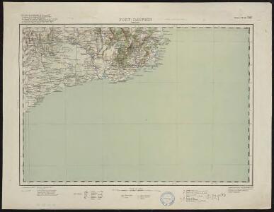
Fort-Dauphin
1 : 500000 Madagascar. Service géographique [Tananarive] : Service géographique de Madagascar
Fort-Dauphin
1 : 500000 Madagascar. Service géographique [Tananarive] : Service géographique de Madagascar
Fort-Dauphin
1 : 500000 Madagascar. Service géographique [Tananarive] : Service géographique du Corps d'occupation
Fort-Dauphin
1 : 500000 Madagascar. Service géographique [Tananarive] : Service géographique de l'Etat Major du groupe de l'Afrique Orientale
Fort-Dauphin
1 : 500000 France. Service géographique de l'armée [Tananarive] : Service géographique du Corps d'occupation
Ile Bourbon, Ile de France. Afrique 57.
1 : 1641836 Vandermaelen, Philippe, 1795-1869
Région Sud
1 : 1000000 France. Service géographique de l'armée [Paris] : Service géographique de l'Etat-major
Farafangana
1 : 500000 France. Service géographique de l'armée [Tananarive] : Service géographique du Corps d'occupation
Tableau d'assemblage de la carte au 1/100 000 de Madagascar
1 : 3500000 Madagascar. Service géographique [Tananarive] : Service géographique de Madagascar
Madagascar. Carte géologique et minière
1 : 3500000 Madagascar. Service géographique [Tananarive] : Serv[ice] géog[raphique] de Madag[ascar]
Madagascar
1 : 5500000 Madagaskar Service géographique
INSVLA S. LAVRENTII, | Vulgo | MADAGASCAR.
[Amsterdam : Joan Blaeu]
Carte Particuliere De L'Isle Dauphine ou Madagascar Et St. Laurens, Levée Par Ordre Expres des Roys De Portugal sous qui on en a Fait la Decouverte. [Karte], in: Atlas nouveau, contenant toutes les parties du monde [...], Bd. 2, S. 225.
1 Karte aus Atlas Sanson, Nicolas Jaillot, Alexis Hubert und Mortier, Pieter
Topographical map of the Island of Madagascar
1 : 4580000 from the original design drawn on the spot by M. Roberts S.I. Neele sculpt. London : [s.n.]
Spezial-Karte von Afrika
1 : 4000000 Blatt 10 Habenicht, Hermann Perthes
CHARTE von einem Theile der OST-KÜSTE VON Africa
Afrika východní
Charte von einem Theile der Ost-Küste von Africa
Afrika východní
Die Ostküsten süd Africa nebs der Insel Madagascar, den Comoren, Sechellen, Amiranten und Mascarenischen Inseln
1 : 5000000 Komory Weiland, Karl Ferdinand Geograph. Instituts
Spezial - karte von AfricaSektion Delacoa Bai (10)
1 : 4000000 1 full d'1 mapa en 10 fulls i estoig Hermann Habenicht; Justus Perthes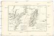
Le canal de Mosambique, l'isle de Madagascar, les etats du Monomotapa et les royaumes voisins
1 : 9600000 Madagaskar Bonne, Rigobert André
Die Ostküste Süd-Africa's nebst der Insel Madagascar, den Comoren, Sechellen, Amiranten und Mascarenischen Inseln
1 : 5480000 entworfen von C.F. Weiland gestochen von Mädel med. Weimar : Geographisches Institut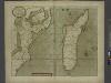
A new draught of the Island of MADAGASCAR ats St. LORENZO with Augustin Bay and the Island of Mombass at Large
from The sea-atlas : containing an hydrographical description of most of the sea-coasts of the known parts of the world.
Africae pars meridionalis cum Promontorio Bonae Spei
1 : 6200000 accuratissime delineato opera Tobiae Conradi Lotter, geographi Augustae Vindelicorum : [Tobias Conrad Lotter]
[Afrika, Blatt 6]
Adolf Stieler's Handatlas über alle Theile der Erde und über das Weltgebäude Stieler, Adolf Justus Perthes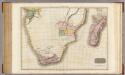
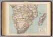
Southern Africa.
1 : 6500000 Pinkerton, John, 1758-1826
173-174. Africa, South. The World Atlas.
1 : 7500000 USSR (Union of Soviet Socialist Republics).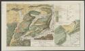
Aethiopia Inferior, vel. Exterior. Partes magis Septentrionales, quae hic desiderantur, vide in tabula Aethiopiae Superioris. [Karte], in: Le théâtre du monde, ou, Nouvel atlas contenant les chartes et descriptions de tous les païs de la terre, Bd. 2, S. 295.
1 Karte aus Atlas Blaeu, Willem Janszoon und Blaeu, Joan Blaeu, Willem Janszoon
Terrenos adjacentes aos rios Zambeze e Chire : desde as suas ultimas cachoeiras até ao mar / mappa coordinado por Alfonso de Moraes Sarmento
1 : 465000 Annotatie geografische gegevens: Opname: 1877-1880 Sarmento, Alfonso de Moraes [S.l. : s.n.]
Ost-Africa, Madagascar.
1 : 12900000 Radefeld, Carl Christian Franz, 1788-1874