Maps of Aïn Defla

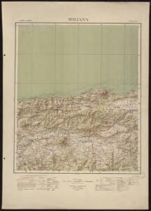
Miliana
1 : 200000 Maumias; Algérie. Service cartographique Alger : Adolphe Jourdan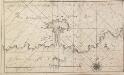
Afteekeningh van de reede van Cercelli bewesten Algiers
Algeria Gerard van Keulen

[Carte d'Espagne et de Portugal en neuf feuilles, 9]
1 Blatt : 31 x 41 cm P.G. Chanlaire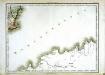
Espagne et Portugal, 9
1 Blatt : 31 x 42 cm Mentelle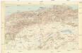
Alger
1 : 500000 Service géographique de l'armée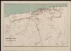
Département d'Alger. Carte des voies de communication
1 : 400000 Calléja; Algérie. Direction de l'agriculture et de la colonisation Alger : lith. Adolphe Jourdan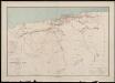
Département d'Alger. Carte des voies de communication
1 : 400000 Calléja; Algérie. Direction de l'agriculture et de la colonisation Alger : lith. Adolphe Jourdan
Carte des étapes de la province d'Alger
1 : 1000000 E. Corny Alger : A. Jourdan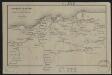
Congrès d'Alger. Carte des excursions
1 : 1000000 Adolphe Jourdan Alger : A. Jourdan
Dépt D’ Alger carte politique
Vidal de La Blache, Paul
Dépt D’ Oran carte physique
Vidal de La Blache, Paul
Dépt D’ Alger carte physique
Vidal de La Blache, Paul

Neueste Generalkarte von Portugal und Spanien, 6
1 Blatt : 70 x 50 cm Schrämbl
[Spanien und Portugal in 4 Blättern, Blatt 4]
Handatlas über alle Theile der Erde und über das Weltgebäude Stieler, Adolf Justus Perthes
Regnorum Castellæ veteris Legionis et Gallæciæ principatuumque Biscaiæ et Asturiarum accuratissima descriptio, 6
1 Blatt : 54 x 42 cm Visscher
Spanische Halbinsel, Blatt 4.
1 : 1500000 Vogel, C.
[Spanien und Portugal, Blatt 4]
Adolf Stieler's Handatlas über alle Theile der Erde und über das Weltgebäude Stieler, Adolf Justus Perthes
Espagne et Portugal. Flle. S.E.
1 : 1250000 Vivien St Martin, L.
Hispania Benedictina
1 : 2100000 Mollova mapová sbírka Carl, Rupert Homann, Johann Baptista - dědici
Theatre de la guerre en Espagne et en Portugal, 4
1 Blatt : 51 x 63 cm Covens et Mortier
Regna Hispaniarum, atque Portugalliæ, 4
1 Blatt : 53 x 64 cm Gerard Valck
Le royaume de Murcie, partie des royaumes de Valence, de Castille Nouvelle, de Grenade [et]c. et l'isle d'Yviça
1 Karte : Kupferdruck ; 44 x 56 cm Jaillot; Dezauche; Cordier chez Dezauche successeur des S.rs De l'Isle et Buache rue des Noyers pres celle des Anglois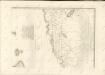
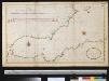
De Middellandsche Zee van Gibralter tot Algiers
Spain Gerard van Keulen
Curiosa nova tabula complectens regnum Valentiae et Murciae nec non Insulas Ivicam, Majorcam et Minorcam
1 : 1350000 per Jacobum Robyn [Luggerdus van Anse schulp.] Amsterdam : [s.n.]
[Spanien und Portugal in 4 Blättern]
Hand-Atlas über alle Theile der Erde und über das Weltgebäude Stieler, Adolf Justus Perthes
[Spanien und Portugal in 4 Blättern]
Hand-Atlas über alle Theile der Erde nach dem neuesten Zustande und über das Weltgebäude Stieler, Adolf bei Justus Perthes