Maps of Haut Atlas

Maps of Haut Atlas

$title$

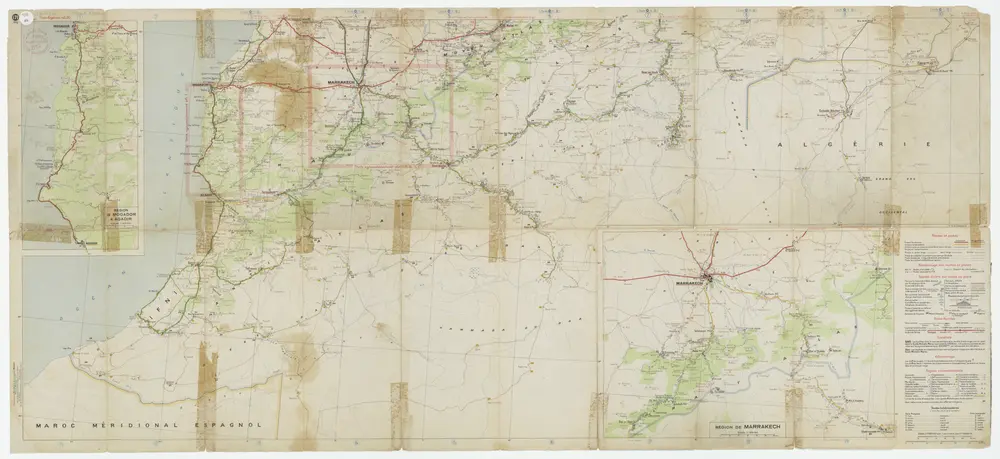
Maroc au 1/1 500 000. Carte des étapes. Routes et pistes carrossables. 1924

1 : 1500000 Maroc. Service géographique Service géographique du Maroc
$title$

Maroc.

1 : 1720000 Andriveau-Goujon, J.
$title$

Maroc

1 : 3000000 Genève : imp. F. Noverraz et fils
$title$

Impero di Marocco.

1 : 2900000 Society for the Diffusion of Useful Knowledge (Great Britain)
$title$

Maroc au 1 500 000e. Carte kilométrique des routes et chemins de fer

1 : 1500000 Maroc. Service géographique Rabat : Service géographique du Maroc
$title$

Maroc au 1 500 000e. Carte aéronautique donnant les caps et distances des principaux itinéraires

1 : 1500000 Maroc. Service géographique Rabat : Service géographique du Maroc
$title$

Maroc au 1 500 000e. Carte administrative. 1937

1 : 1500000 Maroc. Service géographique Rabat : Service géographique du Maroc
$title$

Maroc au 1 500 000e. Carte des tribus. 1935

1 : 1500000 Maroc. Service géographique Rabat : Service géographique du Maroc
$title$

Maroc. Afrique 1.

1 : 1641836 Vandermaelen, Philippe, 1795-1869
$title$

Morocco.

1 : 2900000 Society for the Diffusion of Useful Knowledge (Great Britain)
$title$

Carte du Maroc

1 : 1500000 Maroko Gentil, Louis Emile Larose
$title$

Nordwestliches Africa oder das Sultanat Marocoo

Grosser Hand-Atlas über alle Theile der Erde in 170 Karten Meyer, J. Verlag des Bibliographischen Instituts
$title$

Maroc carte physique

Vidal de La Blache, Paul
$title$

Maroc carte politique

Vidal de La Blache, Paul
$title$

Marocco.

1 : 3200000 Radefeld, Carl Christian Franz, 1788-1874
$title$

Carte du Maroc et de la frontière algérienne dressée au Bureau Militaire du Petit Journal

1 : 2000000 Paris :
$title$

Fezzae Et Marocchi Regna Africae Celeberrima [Karte], in: Novus atlas absolutissimus, Bd. 6, S. 168.

1 Karte aus Atlas Janssonius Offizin
$title$

Nouvelle carte du Maroc

1 : 2775000 A. Taride Paris : A.Taride
$title$

Physisch-geographische Skizze von Marokko

1 : 4000000 Maroko Fischer, Theobald Militärgeographisches Institut
$title$

Marokko.

1 : 2800000 Flemming, Carl
$title$

Marokko

1 : 3000000 Glogau : Flemming
$title$

Fezzae Et Marocchi Regna Africae Celeberrima [Karte], in: Gerardi Mercatoris et I. Hondii Newer Atlas, oder, Grosses Weltbuch, Bd. 2, S. 365.

1 Karte aus Atlas Mercator, Gerhard und Hondius, Jodocus Jansson, Jan
$title$

Fezzae Et Marocchi Regna Africae Celeberrima [Karte], in: Le théâtre du monde, ou, Nouvel atlas contenant les chartes et descriptions de tous les païs de la terre, Bd. 2, S. 284.

1 Karte aus Atlas Blaeu, Willem Janszoon und Blaeu, Joan Blaeu, Willem Janszoon
$title$

Fezzae Et Marocchi Regna Africae Celeberrima [Karte], in: Theatrum orbis terrarum, sive, Atlas novus, Bd. 2, S. 293.

1 Karte aus Atlas Blaeu, Joan Blaeu, Willem Janszoon
$title$

Fezzae Et Marocchi Regna Africae Celeberrima [Karte], in: Novus Atlas, das ist, Weltbeschreibung, Bd. 2, S. 246.

1 Karte aus Atlas Blaeu, Joan Blaeu, Willem Janszoon
$title$

FEZZÆ | ET | MAROCCHI | REGNA AFRICÆ | CELEBERRIMA

describente | Abrah: Ortelius. [Amsterdam : Joan Blaeu]
$title$

Fezzae et Marocchi regna Africae celeberrima, / describebat Abrah. Ortelius

1 : 3000000 Annotatie: Middenonder: Melvia Rio, middenboven: Atlanticvs, (met komma); Origineel is Blad 206 in atlas factice; Annotatie geografische gegevens: Met schaalstok; West boven Abraham Ortelius 1527-1598 [Amsterdami : apud Guiljelmum et Iohannem Blaeu]
$title$

$title$

Mapa del imperio de Marruecos

1 Mapa. Datació aproximada. Lit. Mateu
$title$

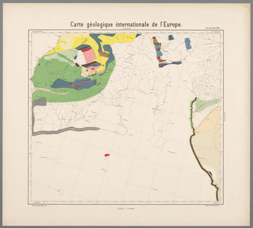
Feuille 43 (A VII), uit: Carte géologique internationale de l'Europe : la carte, votée au congrès géologique international de Bologne en 1881, est exécutée conformément aux décisions d'une commission internationale, avec le concours des gouvernements, sous le dir. de M.M. Beyrich et Hauchecorne

Annotatie: Blad 48 gamme des couleurs; blad 49: bladwijzer en titelblad Heinrich Ernst Beyrich 1815-1896; Wi. Hauchecorne Berlin : Reimer / (Berlin: Institut lithographique)
© MapTiler © OpenStreetMap contributors
How does it work?
These instructions will show you how to find historical maps online.
Getting started
Type the place name in the search box to find the exact location. You can further adjust the search by zooming in and out.
Zoom
Zoom in and out with the buttons or use your mouse or touchpad natively.
Exact Area tool
Click here and draw a rectangle over the map to precisely define the search area.
Set filters
Narrow your search with advanced settings, such as Years (from/to), Fulltext, Publisher, etc.
Results
See the results of your search on the right side. You can scroll down to find more maps of this location.
?

Download OldMapsOnline Mobile