Maps of Oum El Bouaghi

[Algérie (prov de Constantine) et nord de la Tunisie]
1 : 2800000 Bergerac :
Carte routière de la Tunisie au 1er juillet 1905
1 : 500000 Tunisie. Direction générale des travaux publics Paris : Erhard
Carte routière de la Tunisie au 1er janvier 1904
1 : 500000 Tunisie. Direction générale des travaux publics Paris : Erhard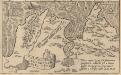
Carthaginis Celeberrimisinus Typus [Karte], in: Theatrum orbis terrarum, S. 412.
1 Karte aus Atlas Ortelius, Abraham Vrients, Jan Baptista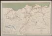
Département de Constantine. Carte des voies de communication
1 : 400000 Calléja; Algérie. Direction de l'agriculture et de la colonisation Alger : lith. Adolphe Jourdan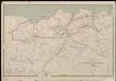
Département de Constantine. Carte des voies de communication
1 : 400000 Calléja; Algérie. Direction de l'agriculture et de la colonisation Alger : lith. Adolphe Jourdan
Carte des étapes de la province de Constantine
1 : 1000000 E. Corny Alger : A. Jourdan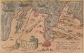
Carthaginis Celeberrimi sinus Typus [Karte], in: Theatrum orbis terrarum, S. 120.
1 Karte aus Atlas Ortelius, Abraham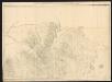
Cartaginis sive potius Tunetani, celeberrimi sinus nec non fortalitii Golettae Tipus quamvis deleti. [Karte], in: Gerardi Mercatoris Atlas, sive, Cosmographicae meditationes de fabrica mundi et fabricati figura, S. 499.
1 Karte aus Atlas Mercator, Gerhard Montanus, Petrus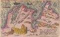
Carthaginis Celeberrimisinus Typus [Karte], in: Theatrum orbis terrarum, S. 311.
1 Karte aus Atlas Ortelius, Abraham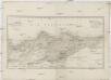
Carte d'une partie de la province de Constantine
1 : 680000 Alžírsko Wenng, Gustav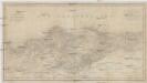
Carte d'une partie de la province de Constantine
1 : 680000 Alžírsko Wenng, Gustav
Constantine
1 : 200000 Maumias; Algérie. Service cartographique Alger : Adolphe Jourdan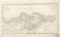
Carte d ́une partie de la province de Constantine
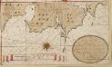
De reede van Teunis en Biserta geleegen agter Caep Bona aen de cust van Barbarija in de Middelandse Zee
Tunisia Gerard van Keulen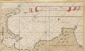
De baij van Tunis
Tunisia Gerard van Keulen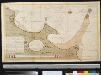
De reede van Susa, Monaster en Comigeras aen de cust van Barbarija besuijde C. Bona in de Middelandse Zee
Tunisia Gerard van Keulen
Tunisia, 1:50,000, Enfidaville
Tunesien 1 : 50,000. Deutsche Heereskarte, nicht für die Öffentlichkeit bestimmt. Grundkartenwerk: Tunisie 1 : 50,000 (1 : 100,000), herausgegeben vom Service Géographique de l'Armée, etc. [Paris?] : OKH/Gen. St. d. H.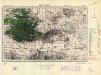
Tunisia, 1:50,000, Bou Arada
Tunisia 1:50,000 , Series GSGS 4225. Great Britain. War Office. General Staff. Geographical Section. [London] : War Office.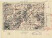
Tunisia, 1:50,000, Medjez El Bab
Tunisia 1:50,000 , Series GSGS 4225. Great Britain. War Office. General Staff. Geographical Section. [London] : War Office.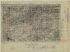
Tunisia, 1:50,000, Beja
Tunisia 1:50,000 , Series GSGS 4225. Great Britain. War Office. General Staff. Geographical Section. [London] : War Office.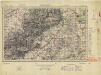
Tunisia, 1:50,000, Tebourba
Tunisia 1:50,000 , Series GSGS 4225. Great Britain. War Office. General Staff. Geographical Section. [London] : War Office.
Porto Bona int groodt
Algeria Gerard van Keulen
Tunisia 1: 25,000, Tebourba 6
Tunisia 1:25 000, Series NWA 16. Great Britain. Army. Royal Engineers. Field Survey Company, 518th. [Cairo] : [Survey Directorate, Middle East]
Tunisia 1: 25,000, Medjez-El-Bab
Tunisia 1:25 000, Series NWA 16. Great Britain. Army. Royal Engineers. Field Survey Company, 518th. [Cairo] : [Survey Directorate, Middle East]
Tunisia 1: 25,000, Tebourba 4
Tunisia 1:25 000, Series NWA 16. Great Britain. Army. Royal Engineers. Field Survey Company, 518th. [Cairo] : [Survey Directorate, Middle East]
Tunisia 1: 25,000, Tebourba 5
Tunisia 1:25 000, Series NWA 16. Great Britain. Army. Royal Engineers. Field Survey Company, 518th. [Cairo] : [Survey Directorate, Middle East]
Croquis de la ville de Constantine
1 : 8300 Saint Hypolite J. Schwegerle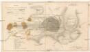
Croquis de la ville de Constantine
1 : 8300 Constantine (Alžírsko) Schnegerle, J.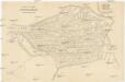
![[Algérie (prov de Constantine) et nord de la Tunisie]](https://images-2.georeferencer.com/images/iiif/169846403367/full/,300/0/native.jpg)

