Maps of Gharb - Chrarda - Béni Hssen

Maps of Gharb - Chrarda - Béni Hssen

$title$

Fès. Vallée du Sebou

1 : 250000 Larras, Nestor Prosper 18..-19..; France. Service géographique de l'armée Paris : H. Barrère
$title$

Mapa del norte de Marruecos

1 : 100000 1 full d'1 mapa en 12 fulls entelats de 2 en 2 fulls dins d'un estoig. Datat entre 1920 i 1930. [Cuerpo de Estado Mayor del Ejército?]
$title$

Carte provisoire de la région de Fez

1 : 100000 Weisgerber, Frédéric 1868-1946 Paris : H. Barrère
$title$

Plan de Taza

1 : 10000 Maroc. Service géographique [Rabat] : Service géographique du Maroc
$title$

Plan of the city of Morocco

Rabat (Maroko) Zeithammer, Antonín Otakar Badía y Leblich, Domingo
$title$

Carte touristique du Maroc

1 : 500000 Fez (Maroko) Service géographique
$title$

Mapa sociológico de la zona de inflencia española en el norte de Marruecos / por D. Antonio Martinez Pajares, Doctor en Derecho

1 : 500000 1 Mapa, col. Dedicatòria ms. de l'autor, datada el 1916. Datació aproximada. Martínez Pajares, Antonio Lit. J. Mendez
$title$

Mapa de la parte norte de Marruecos / por la Comisión de Cuerpo de E.M. del Ejercito ; Talleres del Depósito de la Guerra

1 Mapa. Datació aproximada. Estado Mayor del Ejército (Espanya)
$title$

Reiseweg im Marokkanischen Atlas-Vorland im Frühjahr 1899

1 : 2000000 Atlas (pohoří) Fischer, Theobald Gesellschaft für Erdkunde
$title$

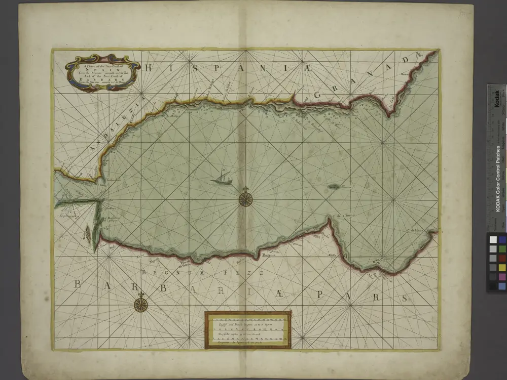
A chart of the sea coast of SPAIN from the Straits mouth to C de Gat and of the sea coast of BARBARY from the Straits mouth to C de Hone

from The sea-atlas : containing an hydrographical description of most of the sea-coasts of the known parts of the world.
$title$

Maroc (500 000 e). Fez

1 : 500000 France. Service géographique de l'armée Service géographique de l'Armée
$title$

Carte générale du Maroc à l'échelle de 1 : 500 000 e. Tanger

1 : 500000 Maroc. Service géographique Rabat : Service géographique du Maroc
$title$

España en Marruecos: mapa de la zona, en el norte del Imperio, asignada a España según el Tratado de 1912 / formado por los señores Elola y Méndez, teniendo presentes los trabajos nacionales y extrageros, dignos de confianza, publicados hasta la fecha

1 : 450000 1 Mapa en fulls, b/n & 2 fulls. Franja de solapament descomptada a les mides. - Conté 4 finestres a escala 1:225 000: Larache y Alcazar; Terreno entre Ceuta y Tetuan; Chafarinas y Cabo de Agua; Cercanias de Melilla y posiciones avanzadas. Datació aproximada. Méndez, J. Lit. J. Mendez
$title$

Carte générale du Maroc à l'échelle de 1 : 500 000 e. Rabat

1 : 500000 Maroc. Service géographique Rabat : Service géographique du Maroc
$title$

Carte nouvelle De L'ISLE de CADIX & du Detroit de GIBRALTAR

1 : 500000 Cádiz (Španělsko) Petit, Jean de Schneider, Ruprecht A. Weidler
$title$

Carte nouvelle de l'Isle de Cadix & du Detroit de Gibraltar

1 : 390000 Cádiz (Španělsko) Petit, Jean de aux depens des Heritiers du feu m. le docteur Homann
$title$

Mapa del norte de Marruecos

1 : 100000 1 full d'1 mapa en 12 fulls entelats de 2 en 2 fulls dins d'un estoig. Datat entre 1920 i 1930. [Cuerpo de Estado Mayor del Ejército?]
$title$

Mapa del imperio de Marruecos

1 Mapa. Datació aproximada. Lit. Mateu
$title$

170: Maroc [noordblad], uit: Maroc en 2 feuilles / Pneu Michelin

1 : 1000000 titelvariant: Carte Michelin Maroc Michelin Paris : Services de Tourisme Michelin
$title$

Maroc au 1/1 500 000. Carte des étapes. Routes et pistes carrossables. 1924

1 : 1500000 Maroc. Service géographique Service géographique du Maroc
$title$

Maroc. Afrique 1.

1 : 1641836 Vandermaelen, Philippe, 1795-1869
$title$

Maroc

1 : 3000000 Genève : imp. F. Noverraz et fils
$title$

Maroc.

1 : 1720000 Andriveau-Goujon, J.
$title$

Physisch-geographische Skizze von Marokko

1 : 4000000 Maroko Fischer, Theobald Militärgeographisches Institut
$title$

Nouvelle carte du Maroc

1 : 2775000 A. Taride Paris : A.Taride
$title$

Fezzae et Marocchi regna Africae celeberrima, / describebat Abrah. Ortelius

1 : 3000000 Annotatie: Middenonder: Melvia Rio, middenboven: Atlanticvs, (met komma); Origineel is Blad 206 in atlas factice; Annotatie geografische gegevens: Met schaalstok; West boven Abraham Ortelius 1527-1598 [Amsterdami : apud Guiljelmum et Iohannem Blaeu]
$title$

Algérie, colonie française. Région du sud

1 : 5000000 Levasseur, Victor 1800-1870 Paris : Combette
$title$

Fezzae Et Marocchi Regna Africae Celeberrima [Karte], in: Novus Atlas, das ist, Weltbeschreibung, Bd. 2, S. 246.

1 Karte aus Atlas Blaeu, Joan Blaeu, Willem Janszoon
$title$

FEZZÆ | ET | MAROCCHI | REGNA AFRICÆ | CELEBERRIMA

describente | Abrah: Ortelius. [Amsterdam : Joan Blaeu]
$title$

© MapTiler © OpenStreetMap contributors
How does it work?
These instructions will show you how to find historical maps online.
Getting started
Type the place name in the search box to find the exact location. You can further adjust the search by zooming in and out.
Zoom
Zoom in and out with the buttons or use your mouse or touchpad natively.
Exact Area tool
Click here and draw a rectangle over the map to precisely define the search area.
Set filters
Narrow your search with advanced settings, such as Years (from/to), Fulltext, Publisher, etc.
Results
See the results of your search on the right side. You can scroll down to find more maps of this location.
?

Download OldMapsOnline Mobile