Maps of Grand Est

Théatre de la guerre actuelle, en Allemagne, en Pologne et en Turquie. n9
1 : 900000 Chanlaire, Pierre Grégoire 1758-1817 Paris : chez l'auteur P. G. Chanlaire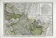
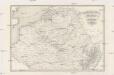
Deuxieme feuille contenant la Flandre francoise, Picardie, Artois, Isle de France, Champagne, Lorraine et Alsace
1 Blatt : 39 x 57 cm Bourgoin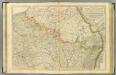
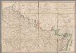
N. France.
1 : 680000 Faden, William, 1750?-1836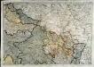
Neueste Generalkarte von Frankreich, 2
1 Blatt : 55 x 78 cm F.A. Schrämbl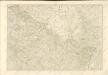
A map of the northern part of France to facilitate the knowledge of the operations carried out by the allied armies against the French Conventional troops
1 : 640000 London : William Faden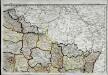
Carte de la république de France, no. 2
1 Blatt : 41 x 58 cm s.n.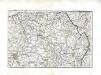
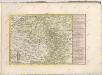
[Nordostfrankreich]
1 Karte : Kupferdruck ; 37 x 56 cm Chanlaire chez l'auteur P. G. Chanlaire rue Geoffroy-Langevin no. 7
Skizze zur Orientirung ϋber den Feldzug 1807

France Flle. N.E.
1 : 1000000 Vivien St Martin, L.
Allgemeine Uebersicht des Kriegsschauplazes am Rhein, der Mosel, Maas, Marne, Seine, Schelde [et].c.c
1 Karte : Kupferdruck ; 48 x 58 cm Güssefeld bey d. Homann. Erben
Flemmings Spezialkarte für den deutsch-französischen Krieg
1 : 600000 Evropa západní Carl Flemming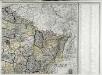
Carte de la France, 2
1 Blatt : 60 x 82 cm de Belleyme
Nordost Frankreich, Belgien und Luxemburg Deutsche Rheinländer

Distribution of German forces on the Western Front
1 : 750000 First World War map of the distribution of German forces on the Western Front according to captured map dates 30th Oct. 1918. Title of base sheet 'Map of the Western Theatre of War'. War Office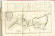

Kriegsschauplatz oder Graenzkarte zwischen Deutschland u. Frankreich enthaltend die Oesterreichische Niederlanden, das Bisthum Lüttich, Chur Cöln, Trier, Maynz, und Pfaltz, Ober, und Chur Rhein, Fränkischer, und Schwäbisher Kreis, einen Theil von Westphalen, Hessen, Cassel, Darmstadt, und Zweybrücken nebst Breisgau, das Französische Flandern, Artois, Henegau, Picardie, Isle de France mit Paris, Champagne, Lothringen und Elsas
1 : 680000 Alsasko (Francie) Ioh. Walch
Kriegsschauplatz oder Graenzkarte zwischen Deutschland u. Franckreich
1 : 680000 Alsasko (Francie) Walch, Johann bey Joh. Walch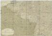
Kriegstheater oder Graenzkarte zwischen Deutschland und Frankreich
1 : 500000 Belgie
Kriegsschauplatz oder Graenzkarte zwischen Deutschland u. Frankreich enthaltend die Oesterreichische Niederlanden, das Bisthum Lüttich, Chur Cöln, Trier, Maynz, und Pfaltz, Ober, und Chur Rhein, Fränkischer, und Schwäbisher Kreis, einen Theil von Westphalen, Hessen, Cassel, Darmstadt, und Zweybrücken nebst Breisgau, das Französische Flandern, Artois, Henegau, Picardie, Isle de France mit Paris, Champagne, Lothringen und Elsas
1 : 680000 Alsasko (Francie) Ioh. Walch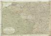
Kriegstheater oder Graenzkarte zwischen Deutschland und Frankreich
1 : 660000 Alsasko (Francie) Müller, Franz Artaria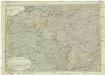
Kriegstheater oder Graenzkarte zwischen Deutschland und Frankreich
1 : 1015000 Evropa západní Müller, Franz bey Artaria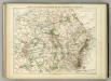
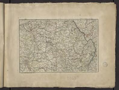
Carte Physique et Militaire de la Frontiere du Nord-Est.
1 : 1000000 Jouvet et Cie.

Zu den Feldzügen 1708 in den Niederlanden und am Rhein
Lille (Francie) Coxe, William K.k. Generalstabes
Belgii sive Germaniae accuratissima tabula
Mollova mapová sbírka Hondius, Henricus Janssonius, Johannes I
Paasche's Frontenkarte, Nr.17. Der Krieg gegen Russland

Paasche's Frontenkarte, Nr.13. Der Krieg gegen Russland