Maps of England

Grossbritannien im maassstabe von 1:1.500.000 : sudliches Blatt : England (ohne die nordl. Grafschaften) u. Wales
1 : 1500000 Petermann, August Heinrich 1822-1878 Gotha : Justus Perthes
Grossbritannien. Sudliches Blatt: England U. Wales.
1 : 1500000 Petermann, A.
Airfields, UK
Great Britain. War Office. General Staff. Geographical Section
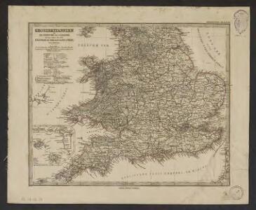
[Grossbritannien, Südliches Blatt]
Hand-Atlas über alle Theile der Erde und über das Weltgebäude Stieler, Adolf Justus Perthes
Grossbritannien Südlicher Theil
Adolf Stieler's Handatlas über alle Theile der Erde und über das Weltgebäude Stieler, Adolf Justus Perthes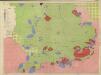
Restricted Flying Areas and Balloon Areas, Air Ministry, GSGS Misc 501
Great Britain War Office General Staff Geographical Section Great Britain Ministry of Defence Survey Production Centre
[Grossbritannien, Südliches Blatt]
Handatlas über alle Theile der Erde und über das Weltgebäude Stieler, Adolf Justus Perthes
England, Ireland.
1 : 3900000 Peterson, Augusts
The roads of ye south part of Great Britain, called England and Wales, containing all ye cities, market towns, post towns, boroughs: and whatever places have ye election of members of parliament &c. all the great or post roads, and principal cross-roads &
1 : 2000000
Road map of Great Britain
1 : 633600 Birmingham (Anglie) Ordnance Survey Office
Angliæ regni florentissimi noua descriptio
1 Karte : Kupferdruck ; 18 x 26 cm Lhuyd; Quad; Nagel Johannes Bussemacher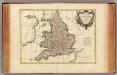
Angleterre.
1 : 2400000 Bonne, Rigobert, 1727-1794
Soubor map
Le Royaume d'Angleterre , divisé selon les sept Royaumes, ou Heptarchie des Saxons, avec la Principauté de Galles, et subdivisé en shires ou comtés
1 : 1400000
An accurate map of England and Wales with the principal roads from the best authorities
1 : 1


A map of ye south part of Great Britain, called England and Wales, containing all ye cities, market towns, post towns, boroughs: and whatever places have ye election of members of Parliament &c. All the great or post-roads, and principal cross-roads &c. with ye computed miles from town to town
1 : 2200000 by Herman Moll [London], Herman Moll
ANGLIA REGNUM IN OMNES SUOS DUCATUS, COMITATUS ET P[ROVINCIAS DIVISUM]
1 : 2300000 Anglie Wit, Frederik de F. de Wit
England and Wales.
1 : 2050000 Carey, Mathew
Map of England and Wales.
1 : 2000000 Carey, Mathew
England and Wales.
1 : 1900800 Carey, Mathew
Map Of England and Wales.
1 : 1900800 Carey, Mathew
Map Of England and Wales.
1 : 1900800 Carey, Mathew
A new map of England and Wales
1 Karte : Kupferdruck ; 51 x 50 cm Rocque sold by I. Rocque near Round Court in the Strand
England und Wales
Hand-Atlas über alle Theile der Erde nach dem neuesten Zustande und über das Weltgebäude Stieler, Adolf bei Justus Perthes
Magnae Britanniae pars meridionalis in qua regnum Angliae tam in septem antiqua Anglo-Saxonum regna quam in omnes hodiernas regiones accurate divisum hic ostenditur quam tabula ab archetypo Vischeriano desumptam
1 : 1300000 Anglie Homann, Johann Baptist Ioh. Bapt. Homan[n]

An accurate map of England and Wales
1 Karte : Kupferdruck ; 58 x 49 cm Kitchin; Bowles; Bowles; Sayer; Tinney; Bowles printed for J. Tinney at the Golden Lion in Fleet Street T. Bowles in St. Pauls Church Yard John Bowles and son in Cornhil and Rob.t Sayer in Fleetstreet