Maps of Morašice

Indikační skica mapy stabilního katastru pro obec Řikovice a osadu Višňáry III
1 : 2880
Rzikowitz - c6720-1-003 - Kaiserpflichtexemplar der Landkarten des stabilen Katasters
1 : 2880
Rzikowitz - c6720-1-002 - Kaiserpflichtexemplar der Landkarten des stabilen Katasters
1 : 2880
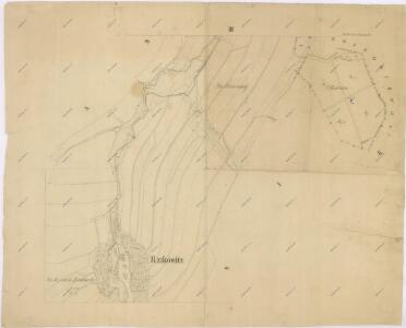
Rzikowitz - c6720-1-001 - Kaiserpflichtexemplar der Landkarten des stabilen Katasters
1 : 2880
Indikační skica mapy stabilního katastru pro obec Lažany II; III
1 : 2880
Indikační skica mapy stabilního katastru pro obec Lažany I
1 : 2880
Indikační skica mapy stabilního katastru pro obec Řikovice a osadu Višňáry II
1 : 2880
Ossik (Osyk) - c5536-1-008 - Kaiserpflichtexemplar der Landkarten des stabilen Katasters
1 : 2880
Ossik (Osyk) - c5536-1-005 - Kaiserpflichtexemplar der Landkarten des stabilen Katasters
1 : 2880
Ossik (Osyk) - c5536-1-007 - Kaiserpflichtexemplar der Landkarten des stabilen Katasters
1 : 2880
Ossik (Osyk) - c5536-1-006 - Kaiserpflichtexemplar der Landkarten des stabilen Katasters
1 : 2880
Ossik (Osyk) - c5536-1-002 - Kaiserpflichtexemplar der Landkarten des stabilen Katasters
1 : 2880
Ossik (Osyk) - c5536-1-001 - Kaiserpflichtexemplar der Landkarten des stabilen Katasters
1 : 2880
Ossik (Osyk) - c5536-1-003 - Kaiserpflichtexemplar der Landkarten des stabilen Katasters
1 : 2880
Ossik (Osyk) - c5536-1-004 - Kaiserpflichtexemplar der Landkarten des stabilen Katasters
1 : 2880
Indikační skica mapy stabilního katastru pro obec Újezdec I
1 : 2880
Laschan (Lažan) - c3825-1-002 - Kaiserpflichtexemplar der Landkarten des stabilen Katasters
1 : 2880
Laschan (Lažan) - c3825-1-001 - Kaiserpflichtexemplar der Landkarten des stabilen Katasters
1 : 2880
Laschan (Lažan) - c3825-1-003 - Kaiserpflichtexemplar der Landkarten des stabilen Katasters
1 : 2880
Mapa pozemků vsí Nová Sídla, Řídký a Sedlíšťka
1 : 3647
Katastrální mapa obce Morašice VI
1 : 2880
Indikační skica mapy stabilního katastru pro obec Morašice a osady Nová Sídla a Malé Sedliště (Sedlíšťka) 6
1 : 2880
Porostní mapa revíru Chlumek (lesy Park a Řídký)
1 : 5760
Katastrální mapa obce Malé Sedliště (Sedlíšťka) a osady Nová Sídla 4
1 : 2880
III. vojenské mapování 4056/4
1 : 25000
Mapa velkostatku Litomyšl
1 : 14500

III. vojenské mapování 4056/4
1 : 25000
Hejtmanství Lytomyšlské